
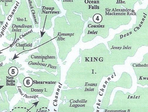
Fisher Channel and Cousins Inlet, looking north towards Ocean Falls – numbered 4. Our route over the previous week had taken us west on Lama Passage to Lizzie Bay Marina, then past New Bella Bella and into Shearwater – numbered 5 and 6. After several days at Shearwater we cruised through Gunboat Passage and back out to Fisher Channel, up Cousins Inlet, to Ocean Falls.
Ocean Falls to Codville Lagoon. On the dock at Ocean Falls we spent a lot of time talking to a sailboat couple across from us and got some really good local knowledge. They are from Campbell River, cruise these parts every summer, and I think they come to Ocean Falls almost every year (I think they must just like sitting on the dock, as there isn’t much to do here after you’ve walked the ghost town once.
Kap was concerned about a weather system that was closing in, and with not much more to see and explore around here, we decided that discretion dictated we should depart. We’d heard several really good reports about how scenic and protected Codville Lagoon is, and also, our new sailboat friends were quite familiar with it. They strongly urged us to give it a try, suggesting their favorite anchorage location in the northern point of the lagoon, tucked in behind a small island.
If you want to see where we are now, or better yet, monitor our route progress as we cruise along, you can go to www.ronf-flyingcolours.com and click on the Current Location link in the upper right corner of the home page. Also, this post is more readable in the online version, plus you can read any of the posts back to 2010 from the archive – just click on the link above to the blog. And don’t forget – you can click on any photo in the post to enlarge it.
A seiner operating just inside the opening to Lagoon Bay (on the outside of Codville Lagoon). If you enlarge the photo, you can see the long line of small white buoys on the surface, and circling around to the shore. The seine line with these buoys holds a section of the net that extends at least a dozen feet below the surface. Surprisingly, this seiner has the end of the seine net attached to the shore (that you can see directly behind the seiner’s stern) – and his little boat is stationed over there.
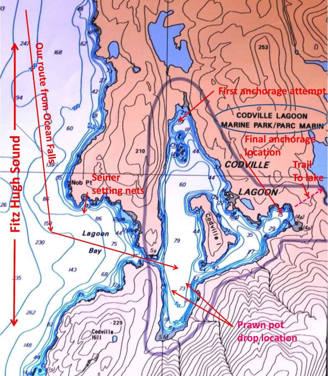
This chart shows our route in from Ocean Falls and into our anchorage at Codville Lagoon. It was an incredibly scenic lagoon, and we also got our prawn pots down for a single soak - bringing up a scant 22 prawns, which didn't merit a longer stay.
We departed Ocean Falls at 9AM, planning about four hours for the 22 mile cruise. The transit down Cousins Inlet was uneventful, and we then transitioned into Fisher Channel.
Before long we spotted lots of commercial fishing boats directly ahead of us and on the east side of the channel – which indicates B.C. Department of Fisheries must have declared a 1-day (or whatever length) “open” day in this particular area. As we approached, it was obvious they were seiners (as opposed to gillnetters or long liners), and we could see the long string of small white floats on the surface that hold the seine net as the appropriate depth. It trails out from the main fishing boat, with typically a large orange float to mark the end. Nearby to the orange float was each seiner’s “small boat” that helps close up the “purse seine” when it’s time to bring in the catch. We had to slow down, as the white seine line floats are hard to see, and the very last thing you want to do is run over one and get it caught up in the prop (and I can’t imagine the trouble you’d be in with the commercial fisherman, and what it would cost to get out of that fiasco).
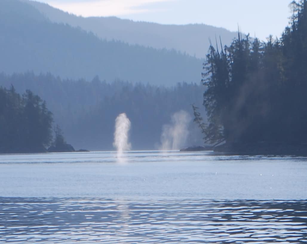
Several humpback whales on the surface and blowing as we turned into Lagoon Bay. With this many blowing at once, we suspected they were doing a small version of a bubble net feeding, and being directly in line with our entrance to Codville Lagoon, we stopped dead in the water.
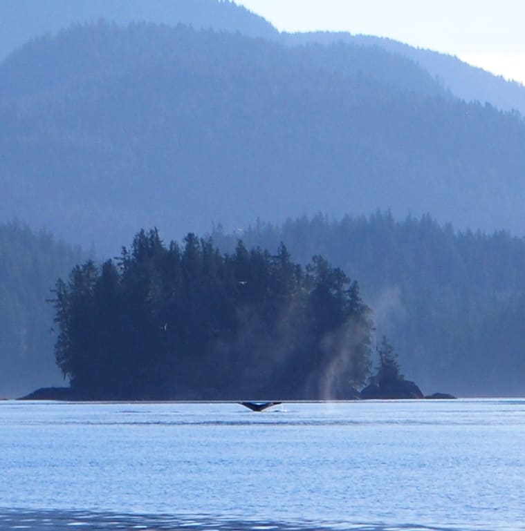
After watching them blow a few more times, we began to see tail flukes as they started their dive. We’ve heard on the whale watching VHF channel that when you see a fluke, it’s likely you won’t see that whale for a while, as they have all the air they need and are diving to cruise depth.
Just as we turned into Lagoon Bay (on the outside of Codville Lagoon), we steered around a seiner operating right in the opening to the bay – at first thinking he had the entire bay opening tied up with his net, but as we got closer it was only about a third. I then spotted humpback whales blowing on the opposite side of the little bay about 100 yards ahead of us. From the frequent blows I could tell it was 3-5 whales, now moving across our bow from right to left, and it looked like they might be setting up for a bubble net feeding.
Kap cut the engines and we stopped dead in the water, figuring we’d better sort out exactly what’s happening before proceeding. Not surprisingly, the seiner continued what he was doing, even though Canadian (and U.S.) laws clearly state that you must cut your engines and stop if whales are that close to you. Either the seiner didn’t see what was going on, or saw it and chose to ignore it. A few minutes later the whales were gone, and we continued into the very narrow opening to Codville Lagoon.
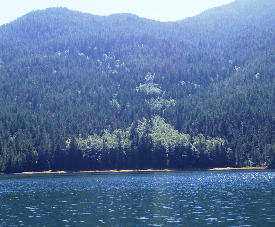
On our tour of the lagoon, this long ago hillside slip was clearly visible. AT the top of it there must be a rock cliff face that calved away, and the ensuing rock slide plowed through all of the downhill trees, widening out as it created an ever greater slide. The first trees to take root were deciduous, and it will look like this until the evergreen firs and cedars take over once again.
We first took a complete tour of the lagoon to get the the lay of the land (so to speak), slowly cruising clockwise around Codville Island in the center, and if nothing really struck our fancy along the way, we’d then head to the small island at the north end and see if we would fit behind it. There were already a half dozen boats anchored in various places behind Codville Island, so we hoped to get away by ourselves if possible.
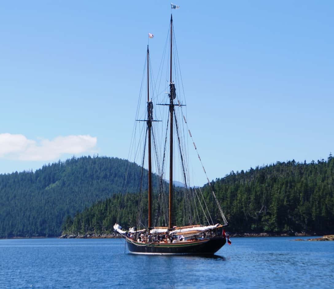
This vintage wooden two-masted sailing ship was anchored nearby when we dropped our anchor at our second location. We think this is the same charter vessel that we’ve seen before in our travels, often times serving as a training ship. This time, though, it was loaded with about 25 high school or college age young people, having a great time on the water. An hour after we arrived they pulled up anchor and departed, so we think it’s just a short day cruise for fun.
There was anchoring room behind the small island and the depth was just 25’, so after hemming and hawing about the best spot, we finally made our choice and dropped our anchor. Once on the bottom we couldn’t get it to set using our normal anchoring technique (letting out about 1½ times our depth, then slowly backing down until the anchor digs in and the chain becomes taut, then letting out our planned scope). More worrisome, through the chain back to the boat we could hear either the chain or anchor dragging on something metallic, which means a gravel or rock bottom, which isn’t good holding. After talking it over – with Kap wanting to try a couple more nearby spots, and I not liking the place at all – we decided to bring up the anchor and motor over to the backside of the main island. (We usually don’t do well on that type of discussion, but we have a rule – if either of us doesn’t like an anchoring location, we don’t stay with it).
We decided to head to the cruising guide preferred anchoring spot behind the large island and near to the scenic trail that leads up to the pristine Sagor Lake a couple hundred feet above and behind the lagoon. On our arrival there were only two boats anchored nearby, the sailing ship shown above and the Golden Hour, the 42’ Nordic Tug that we’d recently seen at Shearwater. As it turns out, we’ve been hopscotching with the Golden Hour for much of the way north, first at Blind Channel (in between Desolation Sound and The Broughtons), then again at Port McNeill, and at Shearwater. On our return from taking Jamie ashore after anchoring, we spotted the Golden Hour’s dinghy returning from a prawn pot check, so we met between our boats to ask how the prawning was inside the lagoon (we were quite interested in doing some prawning north of Cape Caution, in the hopes of finding out if it’s better in this area). The guy indicated that conditions were similar to what we experience earlier in Booker Lagoon, which was a bit disappointing, but nevertheless, we decided to get out our pots and give it a try. To our surprise, after mentioning that we used to have a 42’ Nordic Tug, he invited us over for Happy Hour later that afternoon to compare Tug stories. Right after that we dinghied out to a 300’ deep area just inside the lagoon opening and dropped our pair of prawn pots. Knowing we were planning to depart in the morning, we knew we’d need to pull our pots after a very short “soak”, but it would give us an idea of what’s here, and whether we really should stay another day or so.
Happy Hour that evening was quite interesting. Our guests were Graham and Elise, who live in Victoria and keep their Nordic Tug near Sidney. They’ve only had the Tug for two years (they were formerly sailboat people, cruising with a 35’ Benneteau, and for some reason had gone over to the “dark side” (which is what a lot of sailboat people say when they stop sailing and get a power boat). The Tug was built near Anacortes (it’s the only Nordic Tug shipyard) and was two years newer than our 2007 Nordic Tug). They liked the Nordic Tug OK, but I think they weren’t all that impressed with the “fit and finish” – which we’d agree with, having now had Flying Colours, which was built by ex-furniture/cabinet maker craftspeople in Taiwan. Taiwanese craftsmanship is legendary in the right shipyards, and definitely so at Fleming Yachts.
We purposely kept Happy Hour short, as we still had to pull our prawn pots, fix dinner, and get ourselves ready for our early morning departure. On our return to our prawn pots just two hours after dropping them, we only pulled up 22 prawns, with 15 of them sorted into the small category and 7 large. We decided to hold back the 15 small prawns for a fresh prawn cocktail at the next day’s Happy Hour (wherever we were). This also didn’t encourage us to stay any longer at Codville Lagoon.
Not long after departing Codville Lagoon we passed Dugout Rocks, a frequent reporting station by commercial vessels in their communication with B.C. vessel "traffic" on VHF.
Codville Lagoon to Big Frypan Bay. The next morning, Golden Hour pulled up anchor before 7AM, and we too were gone by 7:30AM. Our cruising route took us southward on Fisher Channel, soon transitioning into the wider Fitz Hugh Sound as we cruised past Calvert Island, but on the east side of the channel from it. Our destination this time was to be determined by the weather reports as we cruised south. We knew a weather system was moving in, and had to make a decision to either sneak around Cape Caution while we could, or find someplace this side of it to hole up in to wait out the blow. Ultimately, Kap really wanted to spend some time in one of the island groups south of Cape Caution, so whatever plans we made needed to factor that in.
Near the bottom of Fitz Hugh Sound we passed Dugout Rocks, a favorite reporting location to “Traffic” (the waterway equivalent of air traffic control) for large commercial vessels going up or down the coast. At that point, we made the decision to head up Darby Channel and duck into Dawsons Landing for a few days, rather than continuing south. Our cruising guide indicated it has really friendly owners, good docks to tie up at, and a real general store for whatever provisions we’d need for getting past Cape Caution and into the island groups Kap wanted to explore.
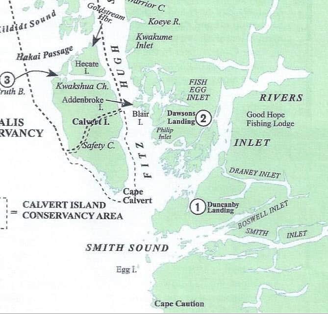
This southern half of the B.C. coast map shows our route southward on Fitz Hugh Sound, then turning east at the top of Penrose Island (where you see the "P" on Phillip Inlet, and up Darby Channel to Dawsons Landing (marked 2 on the map).
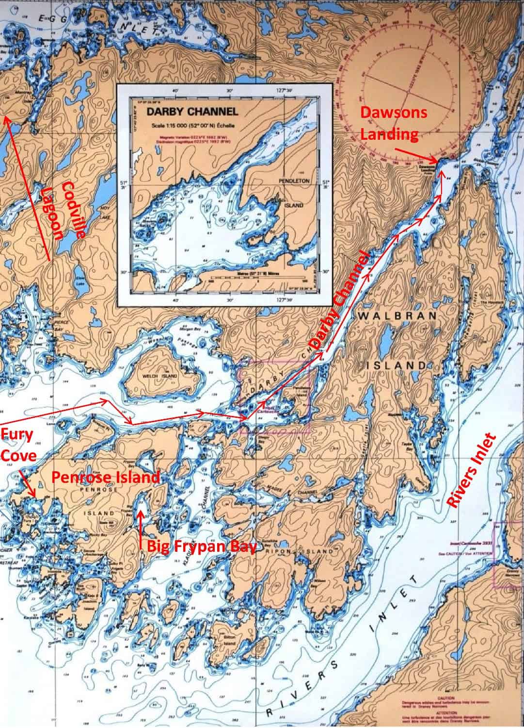
This chart shows our route off Fitz Hugh Sound at Penrose Island, then NE on Darby Channel to Dawsons Landing. After three days there we returned half of the way on Darby Channel to our overnight stay at Big Frypan Bay. Our original plans would have brought us southward on Rivers Inlet, but that would have committed us to Cape Caution, and the weather forecast indicated we needed another day for the weather to settle down.
With our new plan, we turned east as we approached Penrose Island (where we’d earlier spent several days at Fury Cove), running across the top of the island, and slowly making our way through the tricky bits of tiny islands and shoaling areas to enter Darby Channel. This route would take us halfway up the west side of Walbran Island, and at the top of it we’d find Dawsons Landing. An hour earlier we’d managed to raise the general store at Dawsons with our satellite phone, and they told us, no problem, they could squeeze us onto their dock for a few nights. (Boy, that satellite phone has been very useful for us on this cruise, as we’ve been off cell phone access more often than not.)
Darby Channel was wonderfully scenic, probably the longest, narrowest channel we’ve cruised on in a long time, but still a hundred yards wide on average, and plenty deep. We met fishing boats all along the way, and one boat that put a smile on our faces every time we heard them on the radio was “Happy Place” – obviously someone who really enjoys being on their boat. (We hear so many totally unimaginative and just plain bad boat names on the radio, and it’s always nice when we find one that fits the boat and its owners. They turned out to be from Anacortes, and tied directly behind us on the dock at Dawsons Landing.) Our 5½ hour cruise, covering 40 miles, put us onto the dock at Dawsons Landing at 1:00PM. (For example on the bad boat names, a couple of weeks later we pulled into Blind Channel Resort and found a large (whenever I say large, I mean really ugly) boat named . . . get this level of class . . . Ship Faced . . . and yup, registered in The Bahamas – so as not to have to pay U.S. taxes.)
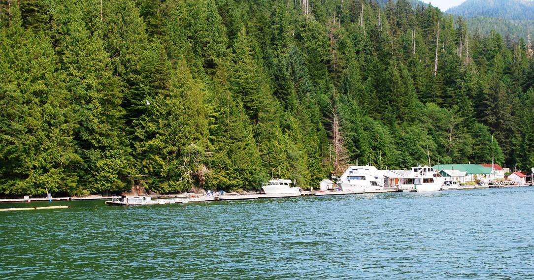
Dawsons Landing as we saw it on arrival. We were assigned to the inner dock, a bit ahead of the bow of the small fishing boat that you can see in the middle of the photo.
In the foreground are three rental cabins used by fishing groups that return each year to this spot. A half of one cabin has been converted to a guest coin-operated laundry, and the other half is a guest shower facility. The docks are wide, and in good shape. You can see the massive logs that support the floats, with a couple of spare logs tied up for use when needed in the future.
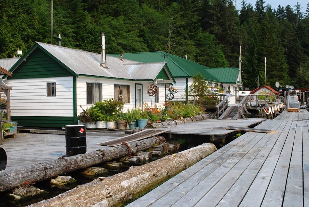
Getting ashore to take Jamie for her twice-daily “walk” involved a steep ramp climb, then an elaborate elevated boardwalk to a tiny patch of weeds that she could jump into. The view to the resort’s backside tells a lot about how the weather in these parts tears down anything manmade.
Getting ashore to take Jamie for her twice-daily “walk” involved a steep ramp climb, then an elaborate elevated boardwalk to a tiny patch of weeds that she could jump into. The view to the resort’s backside tells a lot about how the weather in these parts tears down anything manmade.
There wasn’t anything in itself that was scenic about the Dawsons Landing resort/marina, hugging the shoreline of a bight taken out of Darby Channel. According to our cruising guide, this resort / marina / fishing destination has been here since 1954, operated by three generations of the same family that originally created it. The whole family is incredibly nice, the husband running the docks, and the wife the general store. Their two now-adult daughters grew up here, and the older, after having just graduated university with a BS degree, is working this year as a research assistant at the nearby Hakai Institute in Pruth Bay; the younger one is also at college, but is working the summer at Dawsons Landing helping out wherever needed.
As we soon learned, Dawsons Landing is more well known as a sport fishing destination than for cruising. It boasts some of the best salmon fishing on the B.C. coast – mostly 50-60 lb King and Coho salmon (in good years, 20-30 lb salmon are a waste of the fishing license limits and thrown back as catch-and-release). By the end of the day, the docks filled completely with returning fishing boats, and all of them had large coolers on the dock that they hoped to fill. Surrounding us were boats and fishing people from all parts of the Pacific Northwest, but mostly Washington State. Unfortunately, the salmon weren’t running well while we were there, and most of the boats were coming back with 15-20 lb Coho’s that were all that were biting.
As Kap listened to the weather, it was obvious there was a blow going on in the outside world. We ended up staying 3 nights, and it was a quiet, peaceful place to spend the time. While we didn’t have any cell coverage at all, we had very limited WiFi access by taking our laptops/iPads/iPhones up to a table outside the general store. Early in the morning, and after all of the fishing boats left the dock, we could get very slow WiFi – enough for Kap to download the weather and for me to occasionally get e-mails – but as soon as everyone returned, the WiFi was totally swamped and nothing was coming in. It also didn’t help when a large, 85’ behemoth from SE Kodiak Alaska returned from fishing each day – they must have had some type of electronic gear on board that totally sucked up all of the WiFi bandwidth. (We think that one big problem with WiFi access this past couple of years, from all the way south in Desolation Sound and up to as far north as we went this year is iTunes music that’s stored in the cloud. Almost everyone – but not us – keeps their music and other data in the cloud, and without even thinking about it, the minute they connect to the local marina WiFi – which isn’t industrial strength anyway, but just a cheapo residential box – it’s just totally overloaded as music is streamed.)
It was easy shore access to walk Jamie, although everyone was totally eaten up by mosquitoes and horse flies – plus we had to check Jamie over for ticks on every return. After our third night, Kap finally felt comfortable enough with the weather report that we decided on three options, each involving going south on Darby Channel, rather than our intended new route down Fivers Inlet: (1) if it looked really good, keep on going to Cape Caution; (2) to Fury Cove to duck in to wait a bit longer if it didn’t look good rounding Cape Caution; (3) to a new place, Big Frypan Bay, on the NE corner of Penrose Island. We had doubts about getting into Fury Cove, as it might be jammed up with boats waiting to poke their nose out to Cape Caution; if everyone had left, that meant it was probably good for us to go too.
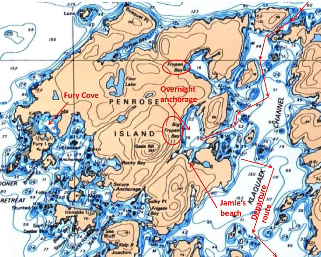
Our route into and out of Big Frypan Bay. This is where we first met up with our newfound friends, Harry and Teri on Steel Tiger, and we'd cross paths with them about six more times on our way south.
Dawsons Landing to Big Frypan Bay. On our morning of departure, Kap waited until she had the 10:00AM weather report from Environment Canada on VHS, plus a last check from the resort’s WiFi with her online weather site, PredictWind. It didn’t look good for a Cape Caution crossing, and we decided it was going to be Big Frypan Bay – and hopefully it wouldn’t be full up with boats (we didn’t expect that, as being on the north side of Penrose Island it’s out of the way for most cruising boats – but we did learn after we got to Big Frypan Bay that Fury Cove had around 20 boats anchored in it, which we think would have to be absolute capacity).
Leaving at 11:00AM, the cruise down Darby Channel was quick and totally uneventful. In 1½ hours we were pushing the nose of Flying Colours into the very narrow opening of Big Frypan Bay. Once inside, it appeared to be completely empty of other boats, but then we spied a commercial-looking seiner anchored around the corner on our right – that was it in the entire bay. Our cruising guide indicated that good anchorage on a mud bottom was available straight ahead, plus our navigation charts indicated there were at least two grassy beach-type areas where we could take Jamie ashore.
Heading there we found an anchorage spot that we both liked and dropped our anchor. When we tried to set it though, we could hear the clanking sound that indicated we were on a rocky/gravelly bottom. We hauled the anchor back up, tried again a few feet over, and it was still the same – but in trying to set the anchor the boat slewed a bit to the side. Based on depth readings Kap was seeing inside the pilot house, it became obvious we were dropping the anchor just ahead of a very large – uncharted – rock or mound, and then as we set it, the chain was being caught on the side of it. This wasn’t good at all, so we brought the anchor up for the second time and decided to explore the next door bay (which became Jamie’s beach for three visits). It didn’t pan out either, and just as we were leaving it, a call came on the VHF radio, “Flying Colours, this is Steel Tiger . . . the anchorage I’m in is very good, about 60’, and with good holding in mud”. It was obviously the commercial seiner that we saw coming in, so we took his word for it, motored over near him, and sure enough, we dropped our anchor in about 60′ and it set well.
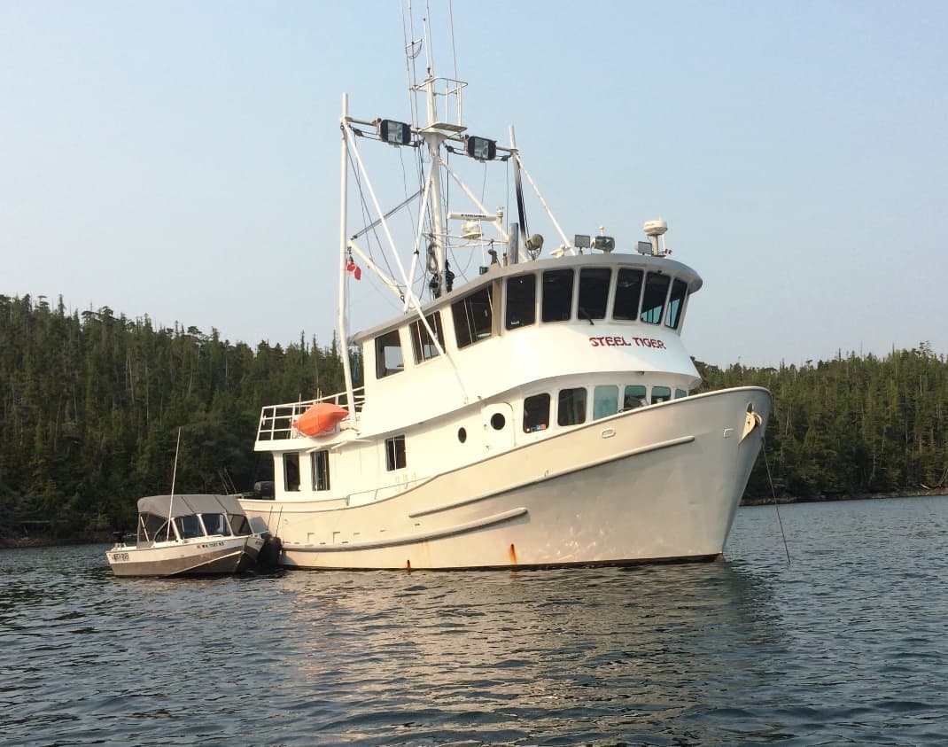
The Steel Tiger may not be the prettiest boag afloat, but she’s incredibly functional. And it's really impressive what this couple from Kent (WA) have done converting her from a working seiner to a cruising boat. Since first seeing it here at Big Frypan Bay, we’ve now run across them about six more times on our way south, and I think we have friends for life. The fishing skiff they tow behind (side-tied while they're at anchor) is one of the best we’ve seen in our travels.
A bit later that afternoon we took Jamie ashore in the dinghy. On our way back we cruised by Steel Tiger to thank him for his excellent anchorage advice. As we approached, a woman about our age came out on the aft deck to greet us. She introduced herself as Teri, explaining that this seemingly-looking commercial seiner was actually converted to a cruising boat, and her husband was busy in the pilot house on one of his never-ending bits of the project. She was very definitely a dog person, and after disappearing for a moment she returned with a Bacon Bit treat for Jamie. After talking a while longer, she invited us aboard to take a tour of the boat. We jumped at the chance. The treats for Jamie continued throughout the tour, and she showed no embarrassment at eating so many of them.
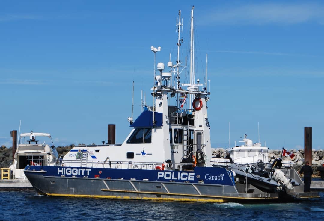
This is what the other half of the “law on the water” looks like in these parts – this one being an RCMP police boat named the Higgitt. It was photographed a month earlier, moored directly across from us in Port McNeill. A sister ship, the Inkster, that we’d seen in Shearwater, was the one in Big Frypan Bay that boarded the Steel Tiger. It’s about 75’-80’ long and seems to carry a crew of four.
Teri and her husband, Harry, are from Kent (south of Seattle), and the Steel Tiger is based at Fisherman’s Terminal in Seattle. That’s where they bought her 14 years ago, and the conversion, still very much a work in progress, has continually been going on ever since – but the good part is, they cruise on her every summer, and typically go to SE Alaska (which they were just returning from). In the accompanying photo, note the small round window halfway back on the lower deck. That’s where the boat’s “house” stopped when it was built as a commercial seiner. From there on back – on both lower and upper deck – is all added since they began the project . . . and I can’t even imagine what that part of the project involved! Inside, the salon (basically, the living area and galley) cover the entire lower deck, from the two widows you can see on the side, right up to the wraparound windows at the front. The inside space is huge – much more so than Flying Colours, even though the vessel is about 58’ LOA (length overall).
The big wraparound windows on the upper deck is the pilot house (where you drive from). Below the lower deck is a large master berth (big enough for a king-size bed), and in front of it is a second berth containing two bunk beds. The whole lower area where the berths are was a huge fish holding tank in its former life – almost certainly stank to the high heaven – but with sprayed-in insulation there’s not even a hint of that. In fact, you can’t smell anything of a fishing boat from anywhere in the boat.
They have a quadriplegic son due to a car accident at some point in the past, and this son likes to cruise with them – so Harry custom-built a residential-type elevator from the lower deck (sleeping area), to the main salon deck, and then on to the upper deck (pilot house). It’s situated in between the smaller round window and the single square window behind it – he made it from all the bits and pieces of a fork lift! That’s an amazing piece of work.
Harry is a retired Flying Tigers pilot – a famous cargo airline dating back to WWII when they flew cargo for the military all over Asia, and then later flew lots of military troop transport for the Vietnam War support – and hence the name Steel Tiger. Harry mostly flew 747s (loved them), and DC-10 and DC-11 (hated them), and as far back as the DC-8). He took retirement from Flying Tigers when it was bought by FedEx, spelling the end of a storied airline. Similar in vein to other former airline pilots we’ve met, Harry’s e-mail address is “formertiger@…., and this is obviously where the boat got its name.
The Steel Tiger had been anchored in the bay for four days before we got here, and the night before our arrival Harry and Teri saw the RCMP police boat, Inkster, enter the bay and anchored on the opposite side. After they’d finished dinner that evening they were sitting around watching a movie on TV and suddenly saw flashing blue light reflecting off the ceiling and walls of their boat’s salon. Looking outside they saw the “little boat” from the Inkster alongside them with two RCMP officers in it. When they stepped outside to the cockpit one officer said they wanted to board the Steel Tiger and check their “paperwork”. For at least a half hour they went through passports, fishing licenses, their fishing catch in two freezers (and the required documentation on each vacuum-sealed bag). They looked up their Customs clearance number from entering Canada on the way south from Alaska to find out how and what they had declared their boat as on entry. They also wanted to see whatever documentation they had on the boat. Being a commercial seining boat, our guess was they wanted to make sure they weren’t masquerading as a cruising boat, when in fact being a commercial fishing boat traveling through undeclared. All ended well, but Harry said it was the first experience like that in all their years of cruising here.
Later that evening we took Jamie ashore, and we could see fog spreading in over the hills on the south side of the bay. It gave us concern for the next morning, as we’d hoped to depart as early as possible. On the narrow approach into Big Frypan Bay, our electronic (GPS-based) navigation charts indicated we were actually on the shoreline, when in fact, looking out the windows we were obviously in the center of the passage. Either the GPS location was off here, or the old navigation paper charts were off by a bit. As a result, Kap was adamant that she didn’t want to exit out the passage unless we had good visibility.
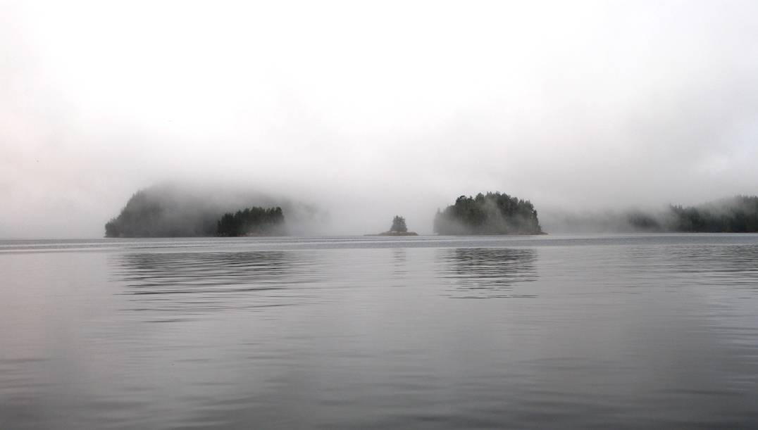
This is what ¼ mile visibility in fog looks like – which is problematic in itself, but manageable when you’re traveling at 6-8 knots. Nevertheless, driving in this type of fog, Kap is always on the wheel, and my head is totally glued to the radar screen. There are far too many idiots operating in this type of condition, figuring they can drive fast and crazy, assuming that no one else would be that stupid. Luckily, they’re helping the gene pool, but also take out innocents with them.
Big Frypan Bay to God’s Pocket. Sure enough, when we awoke the next morning everything outside our windows was absolutely socked in with fog – we couldn’t even see the water right next to the boat when looking out our salon windows. Visibility was under 5’. We were concerned at even taking Jamie ashore – we could obviously locate “her beach” without problem, as we have a Garmin GPS chartplotter mounted on the driving console in the dinghy – but the problem would be finding Flying Colours on the way back.
An hour later the fog lifted a bit, and it soon became apparent that Steel Tiger had departed some time earlier in the dense fog (Kap thought she’d heard an engine start around 5:30, but couldn’t tell if it was their main engine or just their generator to charge house batteries. We took Jamie ashore (and sure enough, it was somewhat problematic finding Flying Colours on our return, but having marked it on our dinghy Garmin chart plotter, we got back in fine shape. We tried to reach Steel Tiger on VHF to see how conditions were outside the bay, but they were far enough away by then that we couldn’t hold a conversation. As the fog continued to lift to a hundred yards, we readied our departure.
On the way out of Big Frypan Bay (love that name, as it really fits the shape of the bay), the visibility was not a problem seeing the narrow passage. Same as yesterday, our GPS showed us totally run aground on the eastern side, when our eyes looking outside showed us right in the middle of the passage. It isn’t often that we find this type of error in the charts, but it makes me glad that Kap is cautious enough that she always operates with a paper charts in the pilot house, even though we’re driving minute-by-minute with the electronic charts. Even the Coast Guard has now loosened their mariner requirements, not requiring you to have paper charts anymore, but the possibility of an electronics failure on the boat (or as we’ve seen now, errors in the electronic charts) makes us glad we are “old school”.
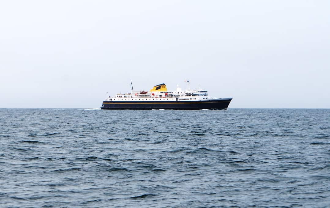
As we rounded Cape Caution we could see the AIS mark for the 375' Alaska Marine Highway car/passenger ferry, the Malaspina. On her weekly run from Bellingham to Alaska, she stops in Ketchikan, Wrangel, Petersburg, Juneau, Haines, and Skagway. She carries 88 vehicles and 500 passengers, traveling at 19 MPH.
When you’re driving in fog there isn’t very much interesting scenery, and besides, you’re just too busy to enjoy it. Before long we were through the myriad islands and channels at the SE tip of Penrose Island, and we broke out into clear air and could see the southern tip of Calvert Island across Fitz Hugh Sound. From here it was a couple of hours across Smith Sound, past Egg Island, and hopefully smooth cruising as we rounded Cape Caution.
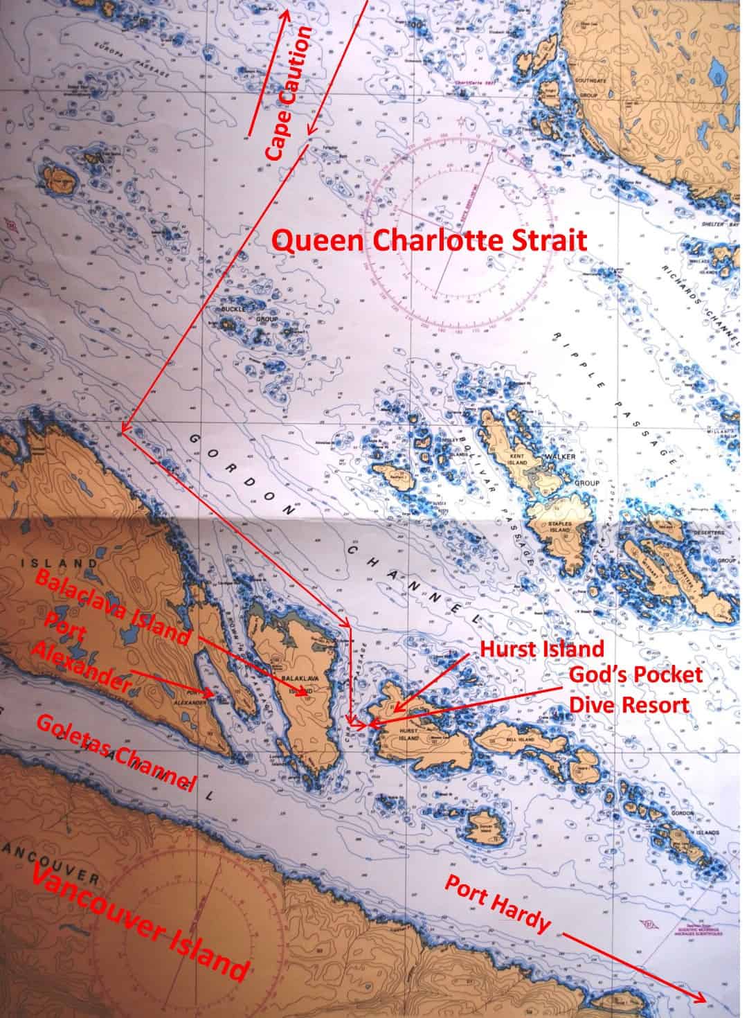
Our route from Cape Caution, across Queen Charlotte Strait, and down along Gordon Channel and the islands off the north coast of Vancouver Island. After rounding Balaklava Island we went into the tiny bay at God's Pocket Dive Resort for a very welcome overnight moorage. The next day we detoured to check out anchorage possibilities in Port Alexander, then headed south to Port McNeill.
It wasn’t to be though. VHF weather reports had indicated the seas should be calming, but sometimes that’s just wishful thinking. As we got further into the open waters of Smith Sound, we were seeing rollers that had started in the Sea of Japan, and hadn’t diminished all the way across the expanse of the Pacific Ocean. They weren’t the 18’ rollers that we’d heard about in Sitka (AK), but they were certainly more than a third of that, and not very comfortable. For two hours we couldn’t do anything but just put up with it, trying one time to tack out further from land to see if the fairly shallow (200-300’) ocean depth was helping to increase the swells.
Just as we rounded Cape Caution we spied an AIS triangle on our radar, and putting the cursor on it we saw it was the Alaska Marine Highway ferry, Malaspina, on its weekly run from Bellingham to SE Alaska. They obviously saw us too on their AIS (we show up as Flying Colours on AIS, which you too can see if you go to www.marinetraffic.com and search for us in their search window – and of the four Flying Colours listed, we are the one that’s identified as a US pleasure craft)– as we saw them courteously change course a few degrees to seaward to give us a wider berth. Other than that, it was very quiet going around Cape Caution, and I don’t think we saw any other boats during that time.
Finally (!!!, and ZuZu and Jamie thought so too), we got behind the protection of the north end of Vancouver Island and the seas quieted down a bit. Kap steered us towards the Vancouver Island side of Queen Charlotte Sound, where it transitions into Queen Charlotte Strait (it’s always confusing to differentiate the two). Our intended destination was a cluster of islands (and island groups) at the NE tip of Vancouver Island, and on the east side of the Goletas Channel from the east coast of Vancouver Island. Kap’s goal was to scout out anchorages that might be useful on a future trip north from Port McNeill – and if we were lucky, to find some prawning areas that we might spend some time in on this trip.
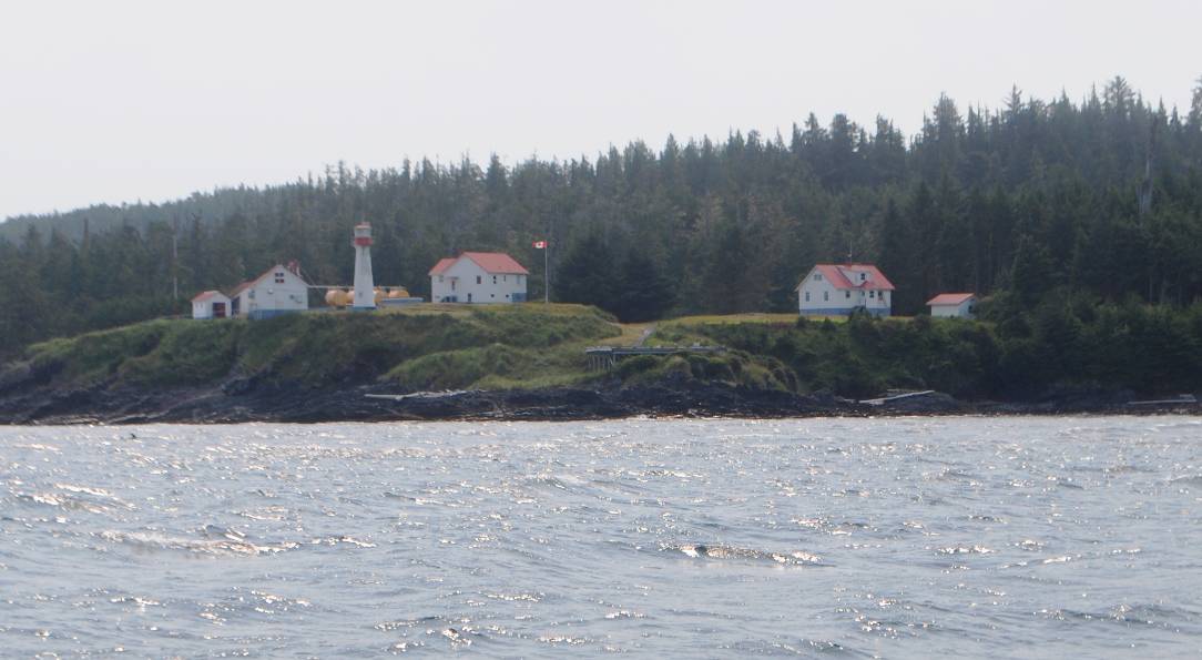
The Scarlett Point Lighthouse is on the SE tip of Balaklava Island, and like almost all Canadian Coast Guard lighthouses on the B.C. coast, they are all very picturesque. This lighthouse was first operated in 1905, and named after a British general who fought in a Crimean War in the Balaklava Battle. It is a manned lighthouse, as are almost all of them along the coast.These were built at a time when lighthouses had to be manned (i.e.,
By 2:00PM we were easily running along the eastern shore of Nigei Island (the northernmost and largest of the islands), and then Balaklava Island – both of them in Gordon Channel. As we rounded the SE tip of Balaklava, the picturesque Scarlett Lighthouse stood out. Just before the lighthouse I called the God’s Pocket Dive Resort on our satellite phone (we still didn’t have cell coverage, and hadn’t had any for almost three weeks). To my surprise they answered the phone. I enquired about moorage for the night, and was even more surprised when the woman on the line said they had room on the dock for us (this is a scuba diving resort, not a fishing or cruising marina, so we had no idea if they even had any dock space at all). We said we’d be there within an hour.
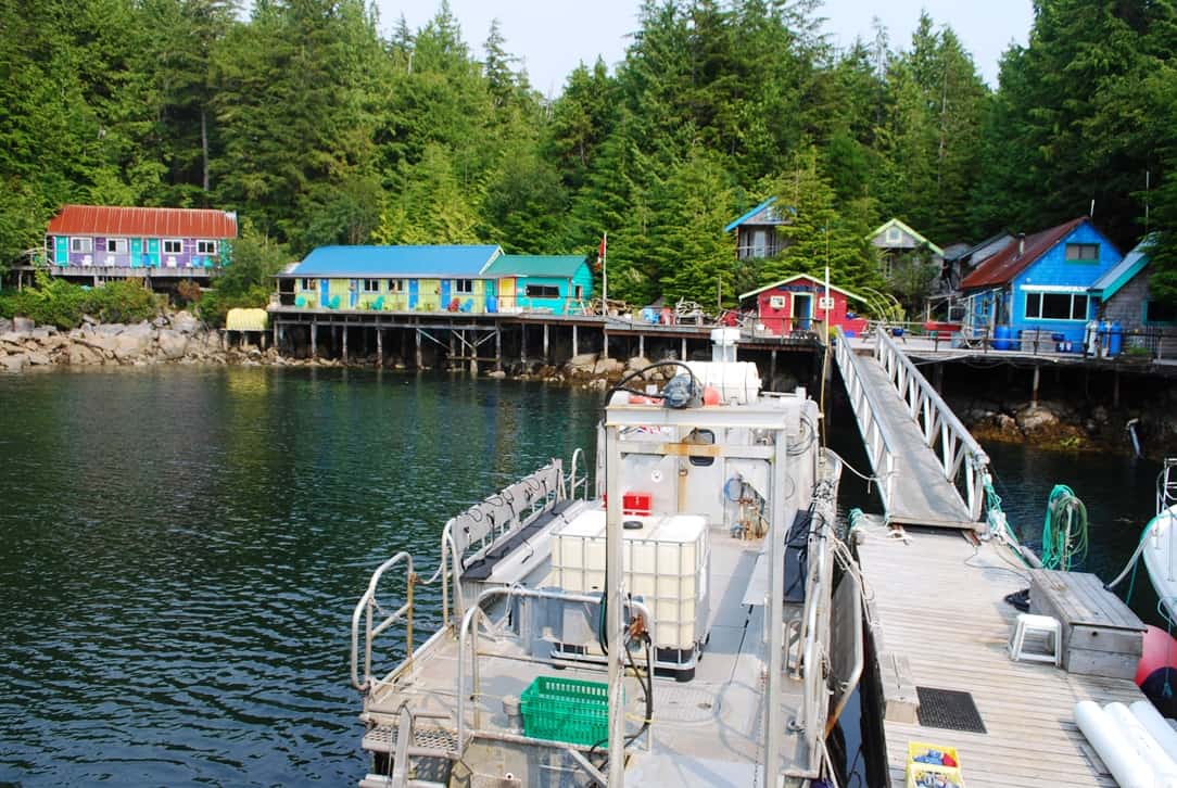
Everything is playful and colorful at God’s Pocket, and the owners and crew are really friendly. Their primary dive boat is just behind our stern, large enough for 12 divers.
The instant we pulled into the tiny harbor, where the dive resort was at the head of it, we knew it was going to be an interesting place – you don’t often see such colorful and well-maintained buildings at resorts around this part of the world. More interesting, it was obvious their dock had barely enough room on it for their dive boat, let alone Flying Colours. Nevertheless, the husband and wife team who created this resort from a fishing camp 18 years ago met us on the dock and got us tied down.
When they saw Jamie – anxious as always to meet new friends – they ooh’ed and aww’ed over her, and then two more of their summer crew also came down the dock to say hello to her. It’s amazing – Jamie helps us make instant friends everywhere we go.
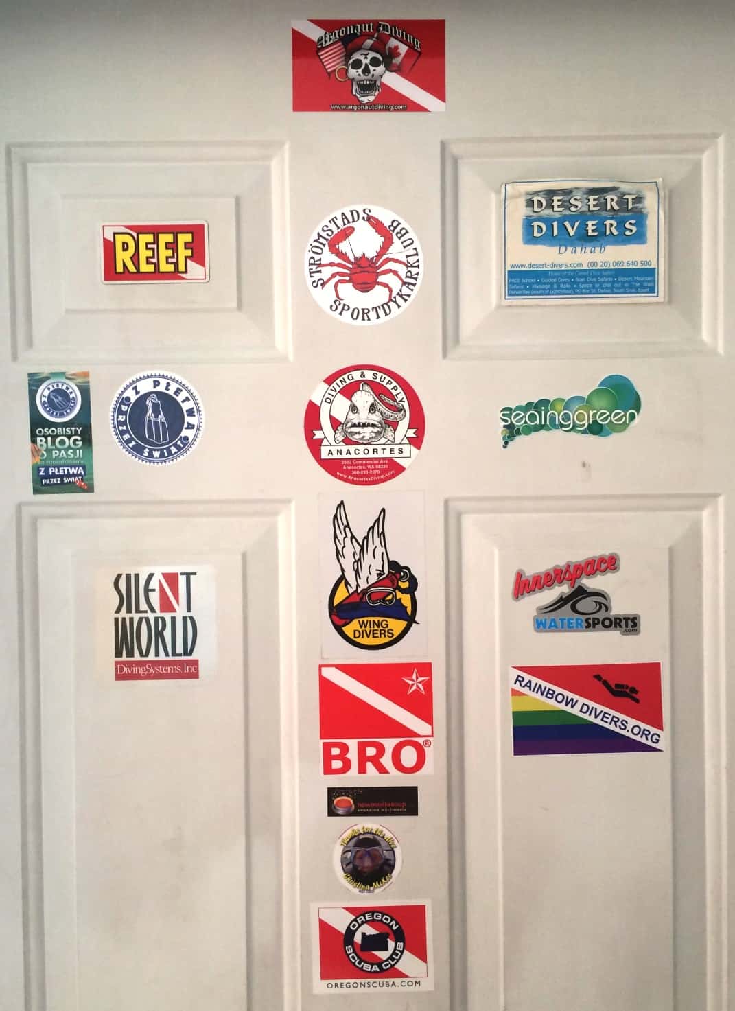
The inside of the Club Room door has stickers from various clubs that bring dive groups to God’s Pocket, and sure enough, our Bellevue dive shop, Silent World, was there. We haven’t gone on any dive trips with them in quite a while, but we still have our equipment annually certified by them.
After chatting for a long while about their dive resort, then going up to the office/lunch room to sign in and pay our night’s moorage fee (the darker blue building at right in the photo), Kap and I grabbed our iPads and PC to head for the resort’s club room (the lower-roofed building section with the yellow door in the building at center to get on their WiFi (turns out we could easily access it on Flying Colours too).
It was a quiet, peaceful night on the dock, nestled in this tiny bay, and we used the time to recover our nerves from the usual anxiety of rounding Cape Caution. For all that anxiety, though, Kap and I both feel that making the trek around that dividing point between the southern and northern half of the B.C. coast is worth it. In the past 10 years that we’ve been cruising in these waters, we’ve seen The Broughtons become as crowded now as the Desolation Sound area has been for years – not to mention filled with the super yachts (those over 100’) that are invading these waters more and more each year. For right now, the remote areas north of Cape Caution still offer some solitude and escape from hordes of cruisers.
Note: As I finish up this post I’m three weeks behind our actual cruising. I still hope to chronicle our last month before we return home, and I really need to get started on that.