
This post is a long one, but I’ve finally caught up with our actual location – Garden Bay in Pender Harbour. You might want to have your favorite libation in hand – a latte, a cup of tea, a glass of wine, or whatever.
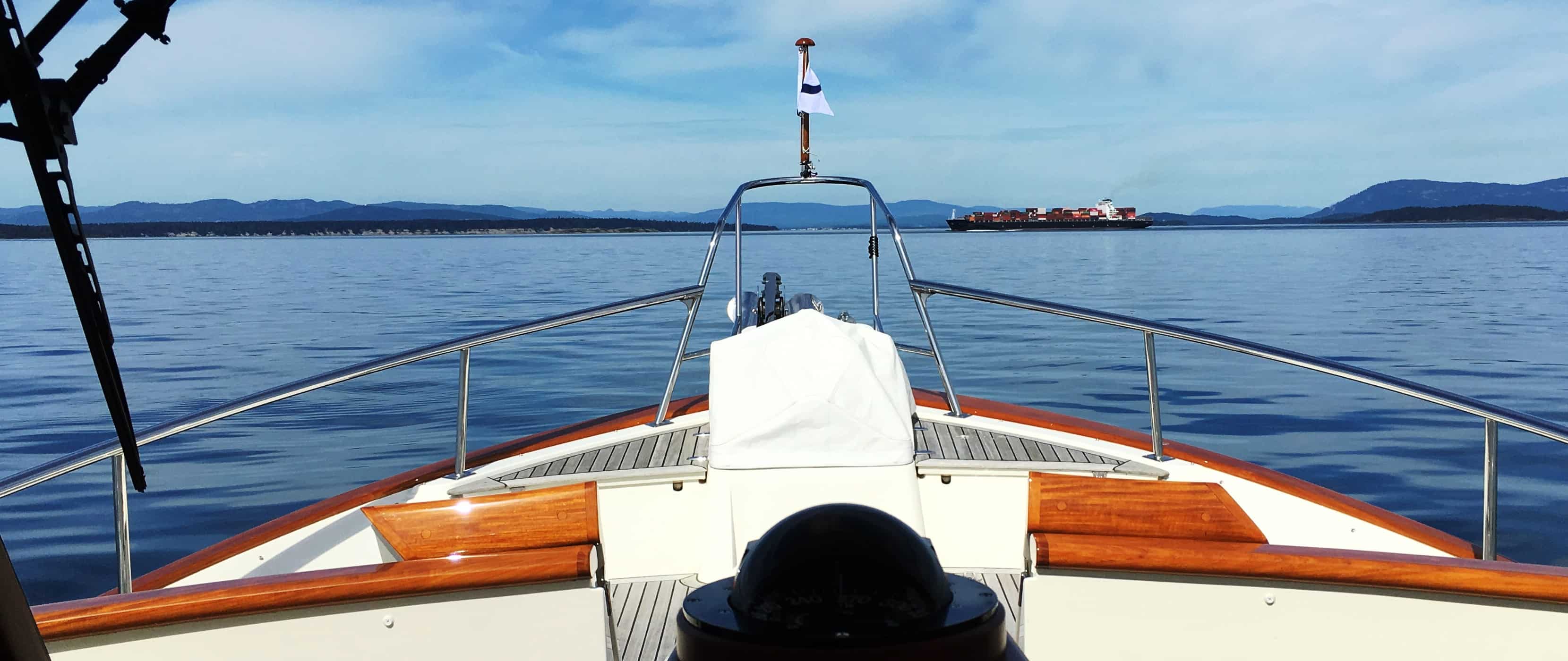
Container ships like this one are common when crossing Haro Strait on the way to/from Sidney. Their speed is deceptive, and you simply can't be complacent about whether you're going to "beat them out" by speeding up to go in front of them.
Thursday-Friday, June 12-14, Port Sidney Marina. Our cruise to Sidney on the 12th was mostly uneventful, but it did have its moments in Haro Strait with a large container ship departing from Vancouver and heading south to either Seattle or out the Strait of Juan de Fuca to the Pacific. The photo at right was taken shortly after I’d altered course to go behind it. Kap had set a radar EBL (Electronic Bearing Line) on the ship’s AIS marker on our radar screen. With an EBL, you watch the other vessel’s movement in relation to the EBL line on the radar screen, and if it moves “behind the line” it means the vessel will pass behind you; if it moves “ahead of the line” it will pass ahead of you; if it’s “coming down the line”, one of you had better alter course. It was coming down the line, and since he’s decidedly bigger than us, I prudently steered right to go behind and slowed down.
Don’t forget – you can click on any photo in the post to enlarge it – such as the one above. You can’t even see the container ship without enlarging it!
Normally I mention about the Current Location link on the blog’s home page, but unfortunately it isn’t working right now. I believe the problem is with Google Maps, and we’re hopefully working to correct it
Also, this post is more readable in the online version, plus you can read any of the posts back to 2010 from the archive – just click on the link above to the blog. Go to www.ronf-flyingcolours.com.
More problematic, though, was an oil tanker about a quarter mile behind the container ship, and not yet knowing its speed, it was difficult to tell if we could pass between the container ship and the tanker. These behemoth ocean-going ships travel faster than one thinks and their speed is really deceptive (watch a 747 on approach to an airport and you’ll think it’s almost stopped in the sky, when in fact it’s rumbling along at about 175 MPH – it’s simply the size that makes it look so slow). Until our new course heading and speed correction settled down, it wouldn’t be possible to set another EBL for the tanker. When we did, though, it indicated we would pass in front of it, but not by a prudent margin. I again slowed down and deviated further to the right.
(As another example of this deceptive viewpoint, when I was getting my on-board Rules of the Road boating training from our good friend, Linda Lewis, back in 2008, I was at the helm of our Nordic Tug as we traversed Seattle’s Elliot Bay from south to north on the way back to our slip at Shilshole Marina. Linda spotted a huge cruise ship leaving the downtown dock in Seattle, and challenged me to determine by sight whether I should go ahead of it or behind it – and to adjust our speed accordingly. From the barely perceptible speed of the cruise ship, I figured it would be easy to go in front of it, so I picked up our speed a bit to be safe. Before I knew what hit me (figuratively speaking), the cruise ship was obviously on a collision course (I say, obviously, as it was easy enough to visually see it was moving forward in the pilot house windows), and in a few scant seconds we’d be under its bow. Red-faced, I throttled back to idle and sheepishly accepted that I’d really been fooled. The best thing Linda Lewis ever taught us was to use our radar, and to set EBLs on any boat or ship that might be a factor.)
Kap’s Nexus still hadn’t been renewed – who knows, with the latest stupid order to round up and deport “millions” of illegal immigrants, so many CBP people could be reassigned that her Nexus isn’t renewed before end of summer, if then. When the two ships passed, we motored on towards Sidney.
On arrival at Port Sidney Marina, Kap steered us to the Customs dock, situated immediately after the entrance breakwater. There were already two boats filling the Customs dock, so we had to float around for about 10 minutes. When one departed, Kap maneuvered us onto the dock and I was on the lines to secure us. I had our paperwork folder and passports all ready to go, so I jumped onto the dock (it’s technically the Captain who does the Customs clearance, and Customs rules forbid anyone else to get off the boat, but it’s something I always do with Nexus call-in, so Kap stayed on board). There was no one in the Custom’s shack, so I went to a table and phone mounted on a pole – which is how you contact Customs if there isn’t anyone there.
A Canadian Customs officer immediately answered. I explained that I had a Nexus, but that Kap’s Nexus was still under renewal review. I gave him my Nexus number and her passport number, followed by our Boat Registration (BR) number when he asked for it. With that, on the screen in front of him he probably has information about every border crossing we’ve made in 50 years, and hopefully he’ll see that we aren’t violent desperadoes. He asked if we had any cannabis, firearms, alcohol, commercial goods, or over C$10,000 in our possession. I answered no to each of them, but to the alcohol question I simply said, “We have our normal ship’s stores on board”. To the last question he didn’t say anything for a moment, so I asked if he wanted “particulars” – and his response brought a laugh from both of us, “No, not particularly”. At that, he asked nothing else, and simply said, “Are you ready to copy down the Customs Clearance number?” I did – it’s an 11-digit number that must be displayed in our boat’s window throughout our time in Canadian waters. With that brief formality, our entry to Canada was complete. We departed the Customs dock and headed directly for our assigned slip in the marina.
Whew! No matter which way we’re crossing the border, or whether it’s using Nexus or a face-to-face entry, via car, boat, or plane, it’s always a relief to have it behind us. I don’t know what it is about a Customs clearance that invokes that feeling, but having done it at least a thousand times over the past 50 years of my life (seriously!), it’s never become commonplace. It’s effectively a police encounter, where they are trained to question you in unknown ways, to get information out of you that you may not want to give, they do their damnedest to keep you in the dark about what’s allowed and what isn’t, and worst, not knowing what the consequences will be if you’ve broken any rules. It’s a strange aspect of travel.
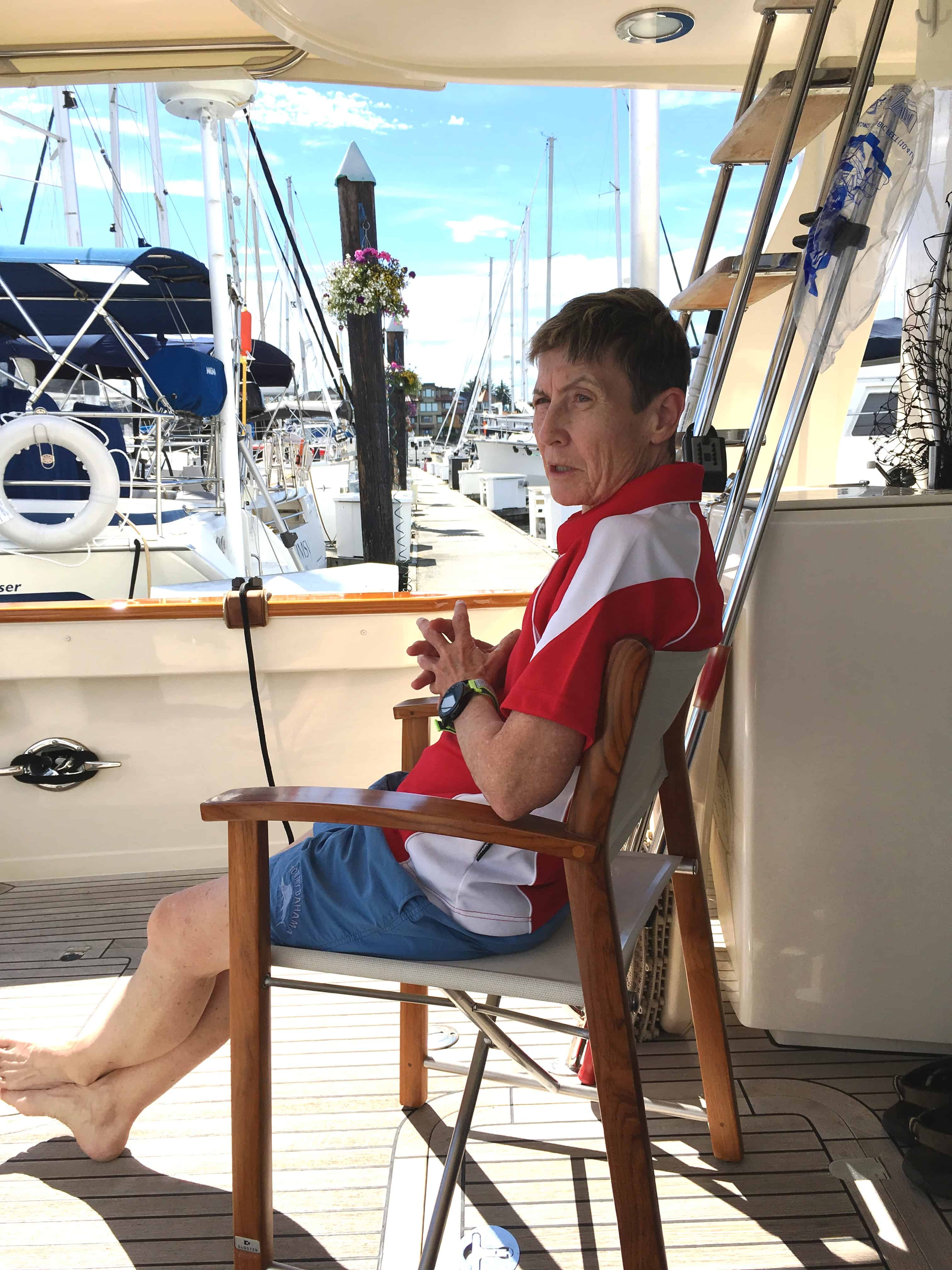
Kap is technically violating Happy Hour here - by not having anything in her hand . . . but a few minutes later she did. It was our first warm day in a long time, and good to sit out in the cockpit.
Our stay in Sidney was three nights, but we didn’t have that much to do, so about 2/3rds of it was spent relaxing. One day we rented a car and drove down to Victoria for a bunch of errands – pick up several bags of Kap’s favorite popcorn at a mall store called Kernels, pick up some sweets at a British shop behind the Empress hotel, pick up some pharmaceutical stuff that we can’t get in the U.S., and importantly, pick up a catnip plant for ZuZu at a nursery on the way back.
On the way back was a mandatory lunch at the Stonehouse Pub in Canoe Cove north of Sidney. The main reason for going there is not only their BBQ ribs, but to share their incredible appetizer, Sambuca Prawns. If there’s nothing else I’ll accomplish on this cruise, it’s to perfect my own version of the Sambuca butter sauce like they make it. It’s an appie on their lunch and dinner menu, along with Coconut Prawns – that we alternate ordering. I’ve tried it at least twice, never coming out the way it should be, but I think I’ve finally found an Internet recipe that might work.
Lastly, Kap always like to schedule our summer trips to Sidney to include the Thursday night farmer’s market that fills the downtown main street, and seems to be attended by every resident of Sidney. There are a dozen street vendors where you can graze your way through a meal, and Kap stocks up on the summer’s hard cider that she really likes from one vendor.
And of course, it’s where we provision for fruits and vegetables that we can’t bring across the border, and that’s ostensibly the main reason we come to Sidney before anywhere else.
Saturday-Sunday, June 15-16, Sidney – Ganges, Seattle Yacht Club Outstation. In years past, Ganges was our popular libation stop, for wine and spirits that would last us through the summer. We knew the owners of a local liquor store quite well, and a month or two before departure each year I’d send them an e-mail with our local B.C. wine order. They’d fill the order and deliver it to the boat on our arrival. They had access to some of the best wines made in B.C. – both coastal and as far inland as the Okanogan Valley– and by reserving it ahead we could make sure we could get it. B.C. wine isn’t available in the U.S. due to some kind of trade friction, so this is our only chance to get it. Unfortunately our friends sold their wine store and retired, drying up our source for the really good stuff (Burrowing Owl Meritage, Osoyos Larose cab, Oculus cab). Nowadays, I take a bit of a chance and stock up more and more on the really good stuff in our own wine cellar at home, including it in our “ship’s stores” that I say to Customs.
Even though Ganges is less than a 2-hour cruise north of Sidney, we still like to stop here on our way north just to get to two of our most favorite restaurants of each summer – House Piccolo and Auntie Pesto’s. Besides, the Seattle Yacht Club has now upgraded their outstation situation at Ganges, leasing slip space for upwards of 10 member boats at Ganges Marina, and that makes staying here free, assuming there’s room on the docks. This time, even though the docks completely filled shortly after our arrival, we got a primo end-tie spot. (Before this, the SYC has been leasing dock space at the next door Salt Spring Marina, but the docks were so disheveled and rickety it was dangerous to walk the docks. On arrival this time we found the docks to be completely ripped out, ready for new docks to be hauled in.)
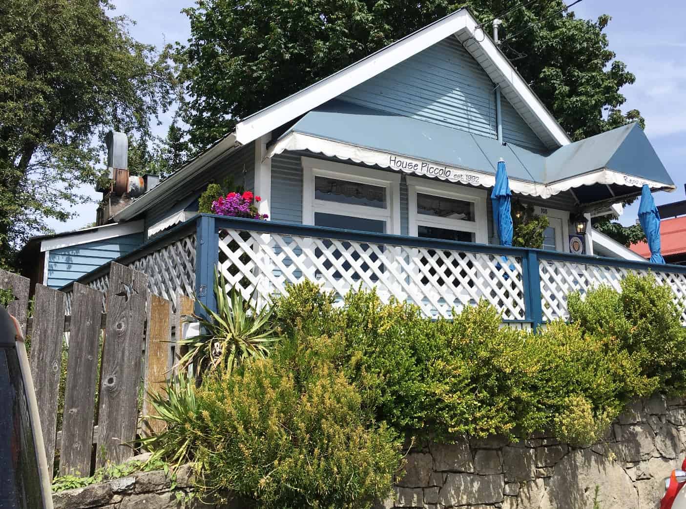
The House Piccolo is in . . . well, an old house, so the dining room(s) meander through all of the main floor rooms. It's been here since 1992, and it's an institution in Ganges.
House Piccolo is easily the finest restaurant on Salt Spring Island and booking well in advance is mandatory (we booked two weeks in advance and had to take an alternative time they could get us in). Kap had a Spring Salmon dish, pan-seared and finished in the oven, with a wonderful tarragon-cream sauce. I had Beef Tenderloin slices bathed in an incredible au poivre (green peppercorn brandy) sauce, preceded by a Beef Carpaccio appetizer. I like both of these dishes well enough that I’ll do some rather outrageous things to get them. I wasn’t disappointed – and it all went well with a very nice Osoyos Larose that we ordered.
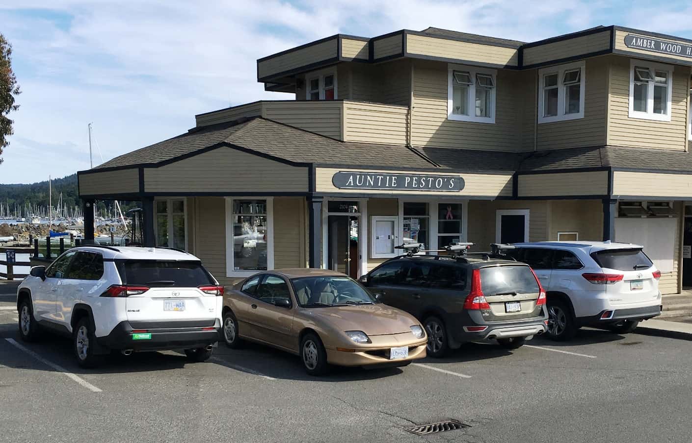
Auntie Pesto is the other restaurant institution in Ganges, with a very different menu than House Piccolo - well, except for their Beef Carpaccio. This raw sliced beef tenderloin dish is more available in Canada and elsewhere in the world, probably the result of our rather stupid liability laws (that always assume the other person is at fault).
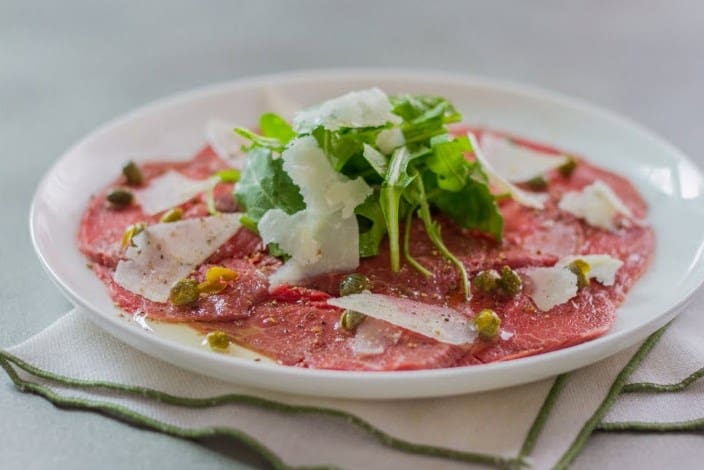
This is what a good Beef Carpaccio dish should look like (I say that because there are some really bad examples at some restaurants). Antie Pesto's is excellent, and looks a lot like this.
Sunday night we had reservations at Auntie Pesto’s, a very nice – but more casual – restaurant that fronts onto a working marina (i.e., fishing boats) on the other side of downtown from our marina. Kap usually has their Pork Medallions – this time it was the Beef Tenderloin Medallions, with some kind of wonderful sauce and vegetables. For me, I can’t get past the Beef Carpaccio appetizer and their absolutely wonderful Spaghetti Carbonara for a main dish.
If you do a search on “Beef Carpaccio images” you’ll find dozens of way to serve it, but whatever . . . it’s raw (and very high quality) beef tenderloin, sliced paper thin, usually arranged in concentric circles on a large plate, maybe with some argula piled in the middle, drizzled with an aioli or truffle olive oil, with shaved Parmesan cheese, and a good dose of capers spread around. One totally unique presentation with Auntie Pesto’s version is, they lightly sauté a good-sized batch of capers in olive oil – which causes them to “poof” like popcorn, making them slightly crunchy, and much tastier. Their Spaghetti Carbonara is a huge dish, with enough to take home that I have a great lunch of it the next day.
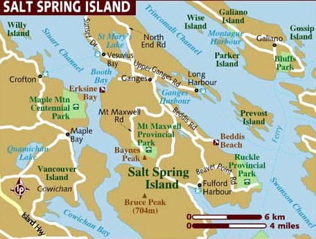
Salt Spring Island is just off the east coast of Vancouver Island, and somewhat oddly shaped due to the deep NW-SE harbours that were left after the Ice Age glaciers receded. You can see Ganges Harbour on the NE corner of the island.
This stopover took two extra days out of our cruising schedule, but we both agreed it was well worth it. Salt Spring Island itself is an interesting place, and the 1960s/1970s hippiness of it is still very evident. It may be before many people’s time, or may not be remembered, but Salt Spring Island was a popular destination for potential Vietnam War draftees to head for. Sparsely populated (much more then than now), fairly remote and situated off the east coast of Vancouver Island, with a population that was decidedly progressive, it became one of the five (or so) most popular places in Canada to head for if you were an American who wasn’t about to head to Vietnam. Many of these Americans stayed on after the war ended, liked the culture and way of life they’d found here, and became Canadian citizens. Ganges is still more of an artsy/craftsy place than anything else, and life is pretty easy here. As you can see from the map at right, Salt Spring Island is a mere 6 miles long (north to south) and about 4 miles wide (east to west), with very remote mountains, and mostly covered in trees. There are lots of vineyards, and lots of remote farms, with only a couple of small towns and villages.
(Me? While attending the University of Washington I got my Army draft notice in 1966, decided the last thing for me was to go to Vietnam as a 3-year draftee, and instead enlisted for four years in the U.S. Air Force (then re-enlisted for a further four years) to qualify for a choice assignment. Overall, I “sat out” the Vietnam War as a lowly sergeant in a top level HQ command post (Langley AFB in Virginia), then a 4-year stint at NATO/SHAPE HQ in Mons, Belgium, and ended up with an incredible 1-year last assignment at a huge computer center in the bowels of the Pentagon. I wouldn’t have missed any of that, but there were a lot of serendipitous things going on that made it all possible (and none of my time throughout all this involved family money or position, bone spurs, or anything else that I’d be ashamed of today). I’m forever toying with the idea of writing my memories of that time in a book I’ve titled (in my head) as The Vietnam War: My Way. That whole time period developed who I am, what I believe, and how I live, more than any other aspect of my life. And just to be clear, I have no negative opinions about the guys who slipped into Canada to “do” Vietnam their way. I just can’t stomach or tolerate a draft dodger who purchased a friggin’ bone spur letter with rich family money.)
Cruising Decisions. By this time, we’ve settled into our cruising enough to give us time to rest, plus time to think more seriously about where this summer is taking us. As you may know, Kap has been doing a lot of Half Marathons this past 2-3 years, having completed a Baker’s Dozen as of this writing. One of the planned destinations for this trip has been to Wrangell, in SE Alaska, where she wanted to run a Half Marathon in their BearFest Festival. The conundrum has been the timing – the race on July 29th – and the ability to get up there and back within other constraints. I’ve always supported Kap’s drive and determination for the Half Marathons, with the belief that this was the maximum endurance test for her particular situation.
Kap has professed all along that she had no interest in doing a Full Marathon, and in fact, I always said I wouldn’t provide any support for a Full Marathon. You know what, though? She now wants to do The Cascade Marathon on September 8th, starting at the Hyak Trail Head at the top of Snoqualmie Pass, then five miles of relatively flat course around Keechelus Lake, through the famous 2½ mile long Snoqualmie Tunnel, then 17 miles of gentle downhill terrain on the old train bed that comes down the mountain to North Bend. The minute she said she wanted to do this, I was all in.
Trouble is, getting south from the Wrangell Half Marathon on July 29th, then getting enough training in to do a Full Marathon on September 8th is a real challenge. Sure, we can get back in time, but where to train for it? There are some spots along the way to get some decent runs in, but is that enough? (I did the math – she’d have to do some 330+ laps around the boat deck just to get in a 6-mile run, and that’s obviously out of the question.) The decision was, bag the Wrangell run in favor of the The Cascade Marathon. So that means we’ll forego the Alaska cruise this year, and it also means we haven’t a clue what we’ll now do for the next month and a half – other than to really enjoy that time aboard Flying Colours.
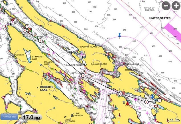
Monday-Saturday, June 17-22, Ganges – Garden Bay, Outstation to Outstation. Kap wrestled (and wrestled) with how and when to head out of Ganges. With our new decision for the summer, we both knew we wanted to spend some good quality rest time at the SYC outstation at Garden Bay – on the other side of the Strait of Georgia, and tucked deep into Pender Harbour. But the weather was looking like we’d either go on Monday, the 17th, or the wind and waves would lock us down to the dock at Ganges for four days. The decision was made to depart at 6:30AM the next morning, head for Gabriola Passage and our entrance onto the Strait, and then point directly across the Strait of Georgia for a late afternoon arrival at Garden Bay. It would be a 66 mile route, with waves potentially rising above ZuZu’s rough-o-meter level.
Trincomali Channel is the usual route on our way north, starting out near the north end of Mayne Island in the south, and splitting into two separate channels at the top end of Thetis Island.
The trip north from Ganges, if not spectacular, is always interesting. It’s a series of long, thin islands, that viewed on a chart (such as the one on the right), indicate that these NW-to-SE running islands were created by Ice Age glaciers. The coastlines we passed are almost completely void of settlement, and there are no towns or small villages along the way (except inside Montague Harbour at the south end) – so it’s peaceful to cruise through here.
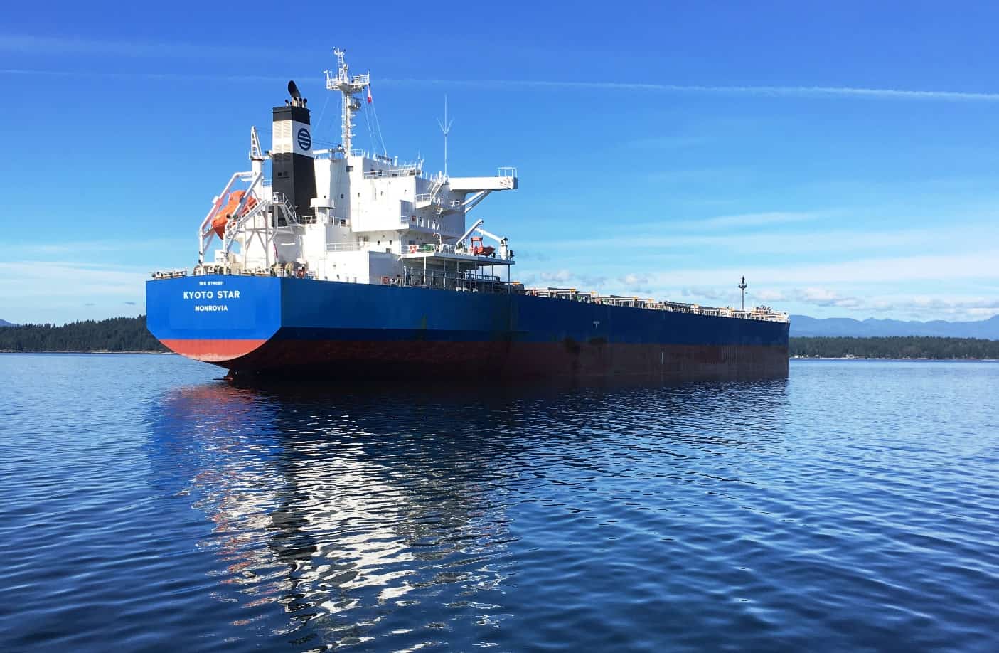
This area near the north end of Trincomali Channel is sort of a holding pattern for ore ships bound for the Orient. This only started a few years ago, so there must be a mining operation that's started up somewhere south of Chemainus.
After passing the northern end of Salt Spring Island the waters widen out and in the distance on the right of the photo we can see an industrial area that’s south of Chemainus. It’s a large lumber operation, as we often see tug and tow log booms – and the occasional large barge loaded with logs – being pulled into it. There must also be a large mining operation there too, as we’re seeing more and more of the massive ore freighters at anchor along here, presumably waiting their turn for loading (and riding high in the water). On this passage there were four freighters within sight, and probably more tucked around the corner at the entrance to Ladysmith Harbour. The ship at right is the Kyoto Star, so likely it’ll be headed for Japan after loading – but the ship is registered in Monrovia.
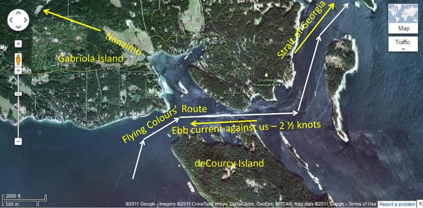
In the past our route out to the Strait of Georgia was through Dodd Narrows and north to Nanaimo. About four years ago we tried Gabriola Passage and found we preferred it, so that's our standard route these days.
As we approached the south end of Gabriola Island, Kap jiggered the speed (I was driving, taking Captain’s orders from her), in order to arrive at Gabriola Passage at 10:15AM, hopefully finding the current at 2½ kts against us. We’re never wild about non-slack passages, given the strong whoop-de-doos we’d find in the middle of the passage (our last passage through here in this direction a couple of years ago scared the daylights out of us when we unexpectedly hit 4 knots current against us and it slewed the boat almost 90° in a channel that’s barely wider than our boat. Luckily, this time another SYC boat passed us just before we got to the passage, allowing us to follow it about 300 yards behind, and we could see how it handled the current before we had to. It turned out to be almost exactly 2½ knots current against us, and there was no problem getting through.
Once out in the Strait of Georgia, the trip across was just long, but uneventful. This was our longest cruise so far of the summer, giving us lots of time to run the water maker and test it out. It worked fine, filling our 400 gallon fresh water tank to the brim. We almost always have fresh water on the docks, except when we’re at anchor or in the Broughton’s (where the marina dock water is often not potable) – but we need to know that before we get there.
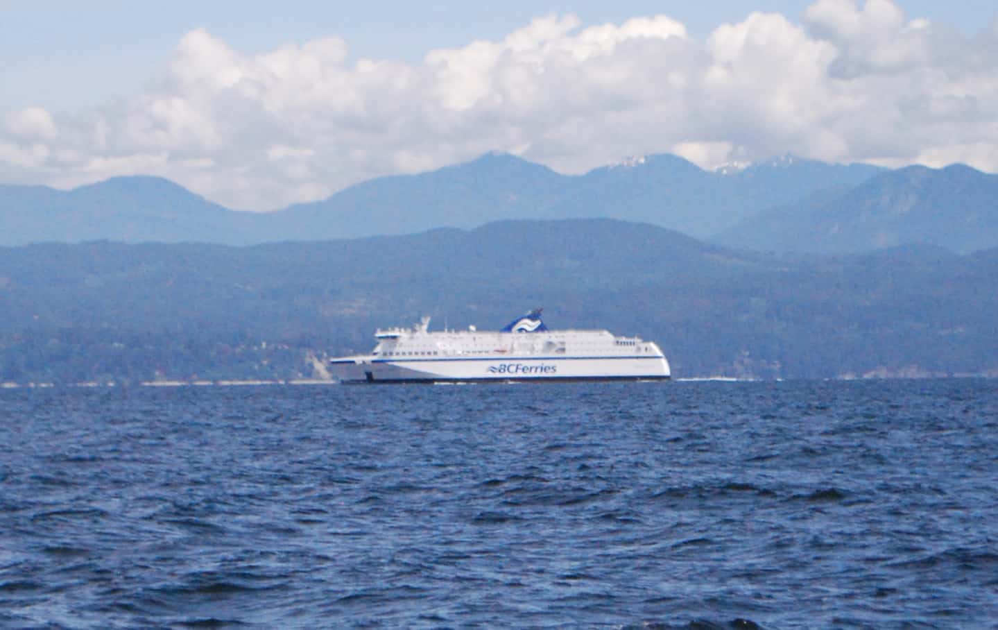
The Northern Expedition, heading north, crossed in front of us about halfway across the Strait of Georgia. Our guess is, it was in Vancouver for repairs or maintenance. Normally it's on a Port Hardy to Prince Rupert run.
Halfway across the Strait of Georgia, at just after noon, we were passed by the very large and impressive-looking Northern Expedition, a B.C. Ferry passenger and car ferry. This was unusual, as we only ever see her north of Port Hardy and on the Inside Passage up to Prince Rupert, where she does a daily 7-hour overnight trip each direction. The Strait of Georgia is not her normal route, and we’ve never seen her around here before, so maybe she was in Vancouver for vessel maintenance and they’re repositioning her. I could find nothing on the internet about goings on.
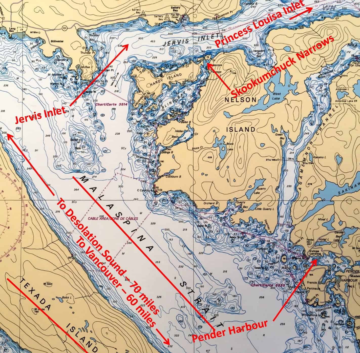
The entrance to Pender Harbour is somewhat protected by Texada Island, with Malaspine Strait between the island and mainland. As I've noted on the chart, it's about midway between Vancouver and Desolation Sound, making it a good stopover spot for American and Canadian cruisers heading north.
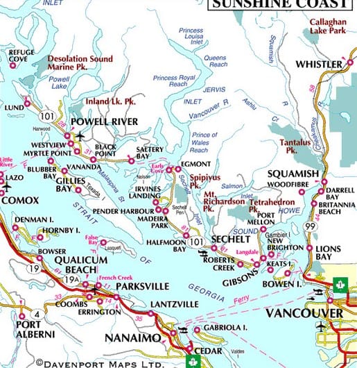
Almost the full distance between here and Vancouver is known as The Sunshine Coast, and it lives up to its name. As a result, the whole area is full of second homes for Canadians from Vancouver and as far East as Alberta (plus a few Americans).few
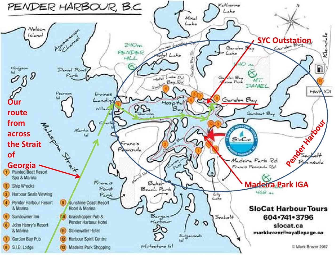
You can see our route from the Strait of Georgia here, plus the route to the Garden Bay outstation. Our provisioning IGA grocery store is across the bay at the tiny village of Madeira Park, and it's an easy 10 minute trip by dinghy. When in training, Kap runs the 10 miles on a menadering backroad, and it's rather hilly.
I talk a lot in the blog about the Sunshine Coast, Pender Harbour, Garden Bay, and Madiera Park, but without any reference information about where they are it’s probably difficult to keep anything in perspective. The second map at right shows the Sunshine Coast, stretching from just north of Vancouver to Jervis Inlet (not market on the map, but just to the left of Irvings Landing). It’s hard to tell from this map exactly what Pender Harbour looks like, so later I’ll have a map of Pender Harbour that shows a lot more detail. Except for Gunboat Bay – which seems to go forever to the NE – we’re about as deep into the harbor at Garden Bay as it gets. There’s a pretty good IGA grocery store at Maderia Park, about a 10 minute dinghy ride away, plus Kap can get a good stock of her favorite hard cider at John Henry’s Resort – #6 on the map, and we get to it by dinghy across Garden Bay, tying up at the Royal Vancouver Yacht Club dock, then walking 100 yards over a little ridge to the resort/marina. I think overall, this is our favorite SYC outstation, with no time limit on how long we can stay here, and believe me, I could stay here for a month.
The first map shows the overall area of Pender Harbour. Just north of our intended entrance to the harbour is Jervis Inlet, which we’ve never explored but need to someday. Near the entrance is a side inlet that goes off to the south just a mile or so inland from the main mouth – and it’s called Skookumchuck Narrows. According to Wikipedia, “Skookum is a Chinook Jargon term that . . . means “strong” or “powerful”, and “chuck” means water, so skookumchuck means “rapids” or “whitewater” (literally, “strong water”), or fresh, healthy water”. This narrows definitely falls in that category, as at full tidal flood it creates a standing wave that would be terrifying if you tried to go through it. It’s a well-known haven, though, for kayakers, and they flock here from all over the world to ride that standing wave (a standing wave is one that stays in place, never rolls on, and you can get positioned in/on it and just ride it for a good long time.
To see what that can do to a boat, you need to take a look at this YouTube video that an SYC friend sent to me several years ago. The link came up broken some time back, but after researching it a bit I contacted the author and he sent me this link: https://m.youtube.com/watch?v=QEfUblSDzww. It goes on for 5:46, so don’t quit early on it. Keep in mind the videographer is a surfer dude, as are all the people around him making comments, so they get pretty salty at times. If you don’t like what you’re hearing, just turn your volume off, but definitely watch the video. And make sure you watch it all the way to the end, as the kayaker explains how he rescued the tug boat captain.
I cadged this photo from the internet. It definitely shows this to be a very scenic trip, and we must do it with Flying Colours one of these days.
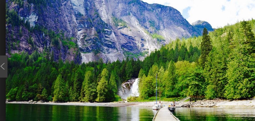
When this photo was taken at the public dock Chatterbox Falls at the head of Princess Louisa Inlet it must have been a very unusual day - only a single boat or two at the dock. Normally, photos show the dock completely full, with upwards of 20 boats tied up and no more will fit.
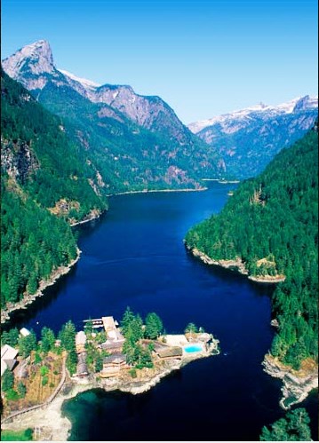
Several miles north on Jervis Inlet is another smaller inlet, named Princess Louisa Inlet. Kap and I have never been there, but it’s a must-do scenic spot in this area, and someday when we’ve exhausted everything else we want to do, we’ll make time for it. It’s almost like one of the Seven Wonders of the World, ending at a spectacular waterfalls. It’s pretty remote, but also very crowded at times, and I think our big fear is that we’ll find it crowded on the day/overnight that we just happen to be there. You should do a search on Princes Louisa Inlet and drool over the incredible photos.
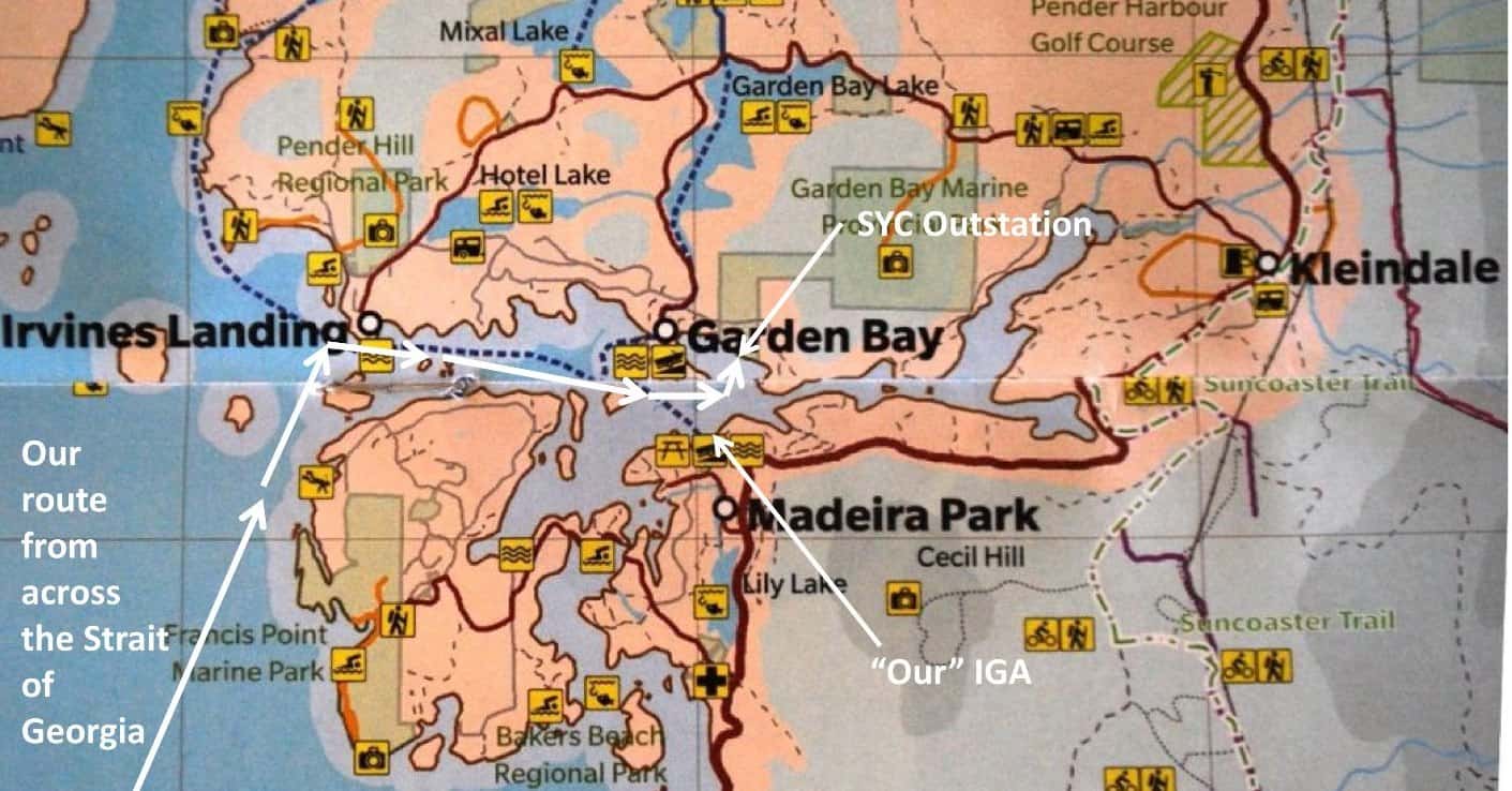
This rather simple map out of a local tourist magazine shows the lay of the land pretty well. Yesterday, Kap made a 10-mile training run, starting at Madeira Park. I dingied over with her, dropped her off, grabbed some groceries, and returned while she ran back - the long and hilly way. It was 10 miles, and her GPS indicated she had climbed the equivalent of 37 stories. Her route started at the 90 degree bend at Madeiira Park, then wound around to the east through Kleindale, around the top by Garden Bay Lake, then south along the lake to return to the SYC outstation.

For most of our week here we've been the only boat at the dock, and that's just the way we like it. So many boats these days are tall behemoths, and when we're stuck with one of them across from us on the dock they block out the sky.
But back to today’s cruise. Just after 2PM we pulled into Pender Harbour and made our way to the SYC Garden Bay outstation. We expected the docks to be full and maybe we’d have to anchor, but to our amazement there were only two or three other boats on our arrival, and our most favored dock spot was available – for a bow-in port tie on the outer end of the middle dock. The outstation manager, Vicky, as always came out to help tie our lines. This is our 13th year coming to Garden Bay – starting with our very first cruise in the Nordic Tug in 2007 – and it’s always good to be back. For whatever reason, the cruising season with everyone else just seems to be later this year, and for much of the time that we’ve been here so far, we’ve been the only boat on the docks. You just can’t beat having your own marina.
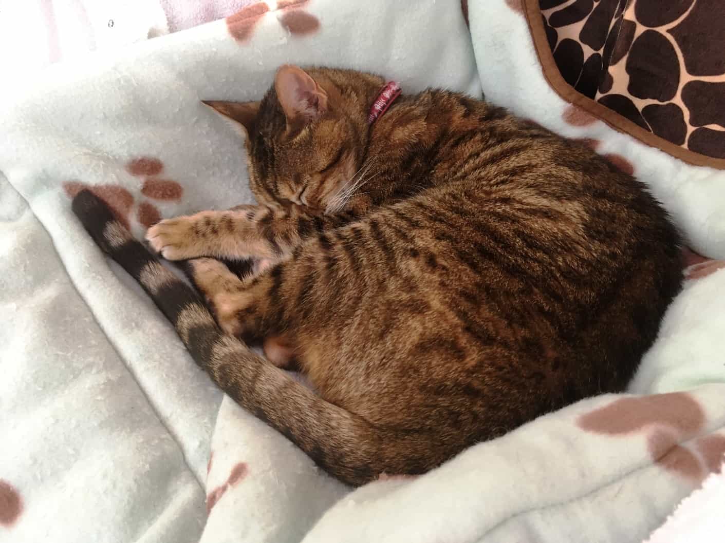 Yes, we’re still having problems with ZuZu. It’s good that we’ve now established she has the start of a kidney failure, and we’ve changed her anti-inflammatory med that likely caused it from Meloxicam to Gabapentin – which had the added benefit of calming her a bit for several hours after each twice-daily dosage. It doesn’t always work, and we think some of it is coupled with some kitty dementia that is possibly giving her a bit of Sundown Syndrome. Either that, or as Kap has jokingly surmised, she’s developing Tourette’s and she’s shouting out random obscenities, or on her cell phone she’s playing out the Verizon loud call every couple of minutes with “Can you hear me now?” On nights when the Gabapentin isn’t working, she can be so loud and restless that we get as little as three hours of sleep. Hard to believe from that sweet-looking cat sleeping in her helm chair bed, huh?
The past week since our visit to the vet has improved somewhat. We’ve experimented with the dosage (now we’re breaking the ½ pill morning and night into a ¼ pill and learning how to bury it better. We also got some “GooFurr” at the local vet in Garden Bay and it seems to help get her to eat the pills better.
Part of the problem too is that she wants off the boat – and very badly sometimes. Once she’s in the cockpit, she’ll be over the side and onto the dock in a heartbeat, and sashaying towards shore. Surprisingly, though, all I have to do is step onto the dock, say “Back on the boat” in a somewhat stern voice, she meows quietly, runs back to the boat and jumps over the side. Next time I let her out, it’s all over again.
This is ZuZu's third escapade under the docks on our cruises north - once at Kwatsi Bay Resort and another time at Lagoon Cove.
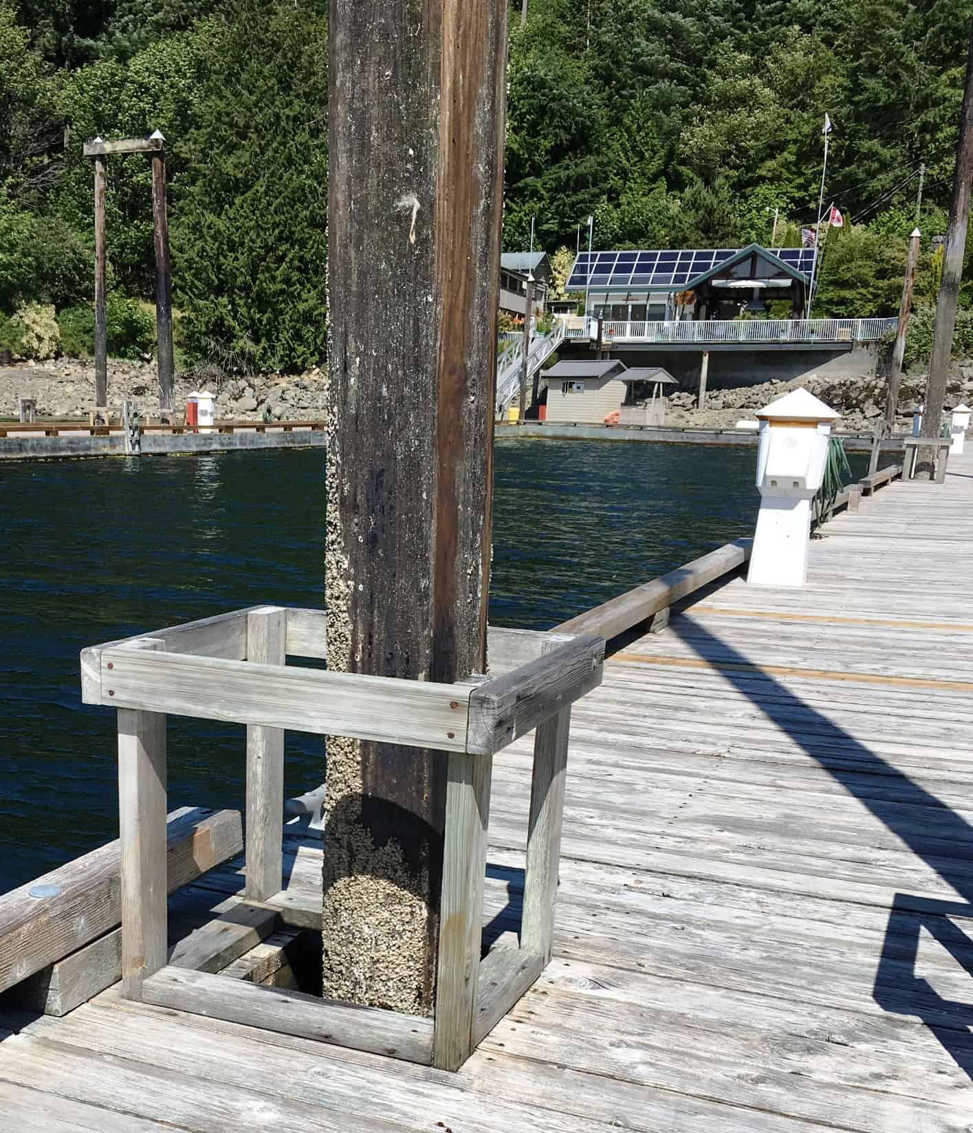
But yesterday took the cake! While Kap was finishing some laundry at the clubhouse, I was in charge of watching ZuZu. She’d been particularly troublesome, continually jumping off the boat the minute I let her out – and meowing loudly and angrily if I didn’t. I relented and opened the salon door to let her out. She immediately ran to the side rail of the boat, jumped up and off onto the dock. I put my sandals on as fast as I could and headed after her, but just as I was stepping off the boat, she ducked down the piling hole in the dock, directly across from the boat. She was out of sight in an instant. This is the third time over the years that she’s gone under the dock or float structures, and if we managed to get her out, it would be difficult. Looking down the hole there was no sign of her, but as I watched it, about five minutes later she poked her head up for about five seconds and then ducked back out of sight. It’s slippery and slimy down there, and there are often shag-nasties living under the dock – such as otters that would just love to get their claws into her.
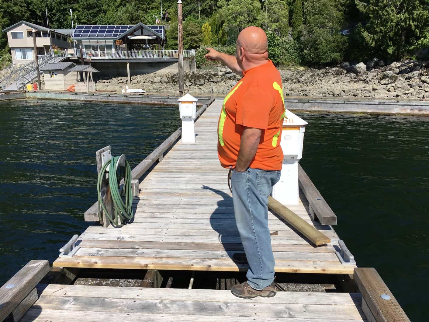
Kap returned a few minutes later and we talked through our strategy. As you can see in the photo, there is another set of piling poles about 100’ toward the shore, plus a half dozen more on the adjoining docks. We had no idea what the structure was like below the decking, so no way to tell just how far she could go, or where she might pop up next. There was nothing to do but contact the outstation manager to see if we could get help – such as pulling up a few of the dock boards to have a look below. At 4PM the husband of the outstation manager came home from work (his name is Rod; her name is Vicky) and Vicky asked Rod to immediately head down to our dock to help.
 Rod showed up with a hammer and various crow bars in hand. He felt there were only two places ZuZu could pop up – and only on the side of dock where she went down. Supporting the dock boards are two continuous stringers that run the length of the dock (shown in front of Rod’s shoes in the second photo), and where each dock meets there’s a facing board that would keep her from traversing to the next dock.
Rod quickly pulled up two boards next to the hole she went down. Peering under it in both directions, ZuZu was nowhere to be seen, and that surprised Rod. He went down past the next piling pair towards shore, wrestled out the half dozen nails that fasten the boards and took up two more. Again, no sign of ZuZu. We stood there talking, wondering where she could be. Suddenly Rod asked me what color ZuZu is – and I told him she’s tiny, and a gray spotted tabby. He turned and point towards the ramp from shore to the docks (upper left corner of the photo), and said, “Is that her coming down the ramp?” Sure enough, it was ZuZu. She was coming back from shore leave, with a jaunty bounce to her step, headed straight down our dock, and jumped aboard Flying Colours.
Kap and I were dumbfounded. We’d been continuously watching the two piling holes that she could have come up from, and never spotted her. Whatever, she totally fooled us, and now she was back safe – and it gave us some assurance that she’d come back if she got out again. This morning by telephone I ordered up a generous gift certificate for dining at the best restaurant in the area and had it mailed anonymously to Rod and Vicky (Club rules prohibit members from paying any money or gifts to outstation managers, but this was special).
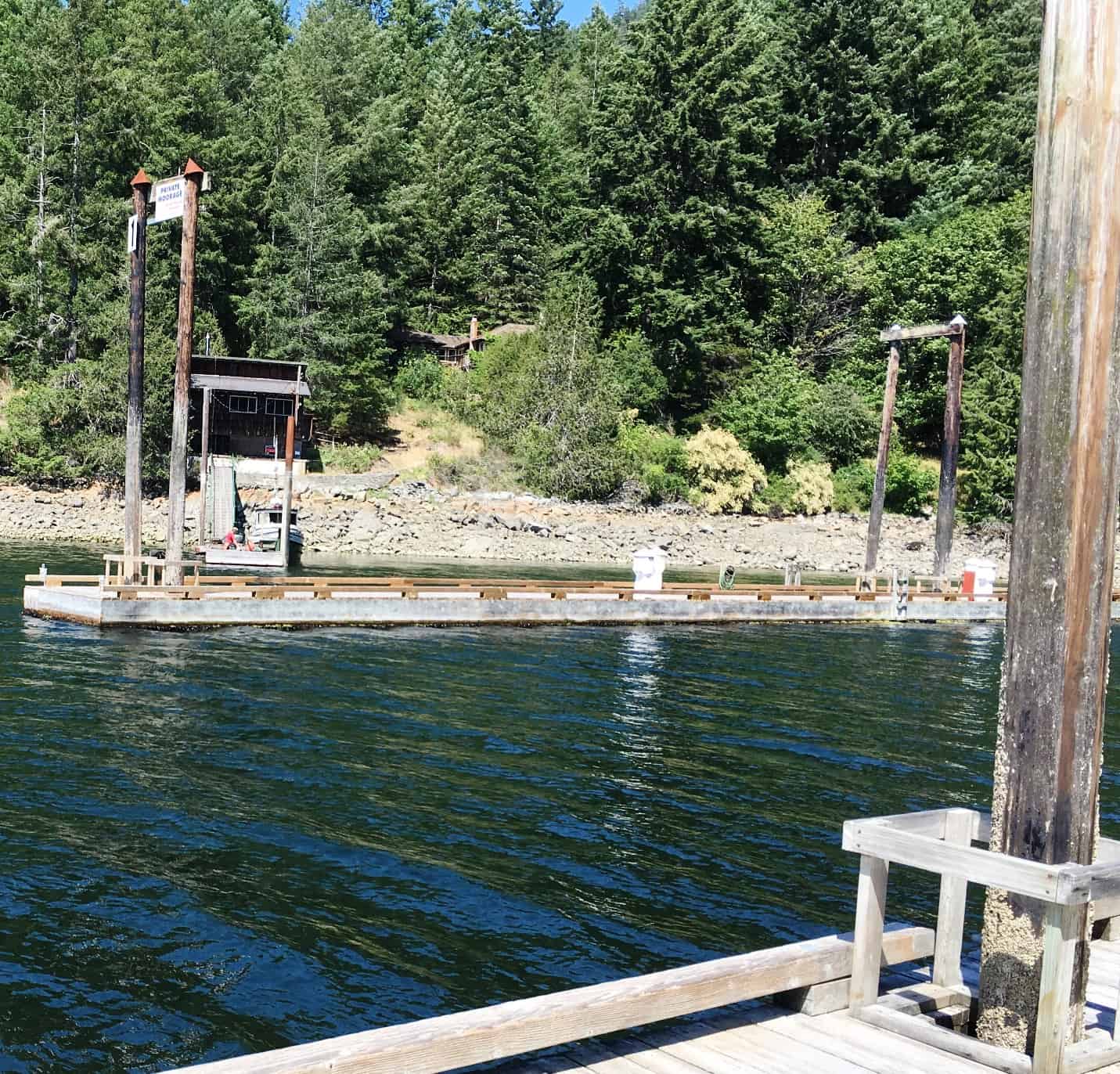
Edith Iglauer's house sits about 100' back from the shore, just to the left of the photo center. It's her dock and boat house at the shore, and her son is there almost every day work on restoration of the tiny fishing boat that's tied to the dock. The entrance to her property is on a separate lane from the SYC's property, so there's no way to communicate with anyone there. Surprisingly, no one waves from dock to dock, or yells hello back and forth. It's too bad.
Another piece of local lore. The SYC outstation’s longtime next door neighbor, Edith Iglauer, died earlier this year, just two weeks shy of her 102nd birthday. I never met her and knew very little about her, but from what I know, she would have been one of my most favorite people. An American, raised on the U.S. East Coast (Cleveland), her interest in Eskimo culture led to several freelance writing assignments with The New Yorker magazine beginning in 1966. As a freelance journalist she wrote dozens of articles for it and other magazines over the decades, plus four books. While in Vancouver in the early years she met and married a commercial fisherman, and they set up life here in Garden Bay, tucked deep into Pender Harbour. Her first full-length book, Fishing With John, was about her experiences learning to fish on her husband’s tiny boat. After he died, Edith stayed on in their small cottage by the bay, and lived out a very long life. In 2007 she starred as herself in one or more of the early episodes on the History Channel series that ran for eleven seasons (2007-2017), titled Ice Road Truckers, about “the activities of drivers who operate trucks on seasonal routes crossing frozen lakes and rivers, in remote Arctic territories in Canada and Alaska”.
To my knowledge there was never any socializing between Edith Iglauer and SYC members, and in fact, relations with the SYC were a bit frosty a few years ago when the club added a new dock that she felt encroached on access to her dock, but that somehow got resolved with some smooth talking by an SYC committee (the dock is the one you can see in the photo at right).
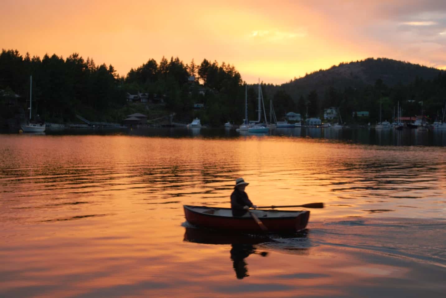
This is a photo I took in 2011 on a visit to Garden Bay. It's easily one of the two or three best photos I've ever taken, and it was totally a grab and shoot photo, with no time to prepare. The lady in the rowboat was returning home after delivering dinner that evening to Edith Iglauer, who would have been in her early 90's at the time.
In her later years, Edith Iglauer wasn’t able to cook her own meals, and each evening we’d see an elderly British lady (also a widow) who lives a half-mile or so around the corner on Gunboat Bay rowing a tiny boat over to deliver Edith’s dinner. On our Fall 2011 visit to Garden Bay, one fine evening Kap and I were sitting in the cockpit watching an unbelievable sunset. As I was snapping photo after photo of the sunset, this lady was returning home and came into view about 50’ off our stern. I never take someone’s photo without asking, but I knew the time she’d be in the frame would be short – so I decided to snap the photo and ask permission afterwards. She heard the camera shutter click and looked over – giving me an opportunity to mention what I’d done. She rowed over to our stern and we chatted for about a half hour. We learned she was British, she told us of her friendship with Edith Iglauer, and the story behind her meal deliveries. We found out her name was Anne Clemence and got her e-mail. She ended up inviting us down to her waterfront house, which regrettably we couldn’t because we were leaving the next morning on our journey south. We later communicated via e-mail and sent a copy of the photo so she could send it to her brother in England. These sunsets in Garden Bay are not unusual, and we have no idea why they occur so frequently – but this sunset has given me one of the best photos I’ve ever taken.
We’ve now spent a bit over a week at Garden Bay, could easily spend another week relaxing, but instead we’ll likely head north tomorrow (Tuesday) for the Desolation Sound area – specifically the SYC Cortes Bay outstation for a few days. Stay tuned.