
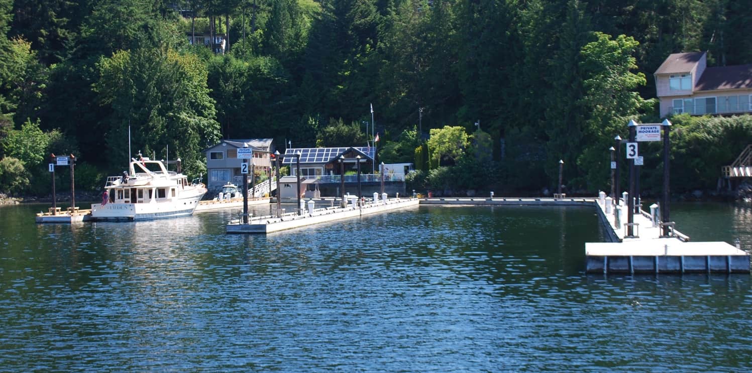
On our arrival at Garden Bay the only other boat on the docks was Couverden - our friends Steve and Andrea that we'll be cruising with this summer. We nosed in to the end of Dock 2, our preferred moorage spot, as it gives us an unobstructed view out to all of Pender Harbour (we're actually in a small corner of the Harbour, called Garden Bay). The building at the head of the docks with the solar panel-looking roof (it isn't solar, but rather, skylights), is the clubhouse for SYC member use, and the area on the right of it (with the peaked roof) is the BBQ and patio area for Green Boxes. The tan, 2-story building to the right of the Couverden bow is the live-in outstation manager's house. (Of the 11 SYC outstations, five of them have full-time, live-in caretaker's.)
Sunday, June 24; Two SYC Outstations – Garden Bay to Cortes Bay. Our stay at Garden Bay, while it was five days long, it felt like it was short and uneventful. It was our first chance to really relax in months and we took advantage of it.
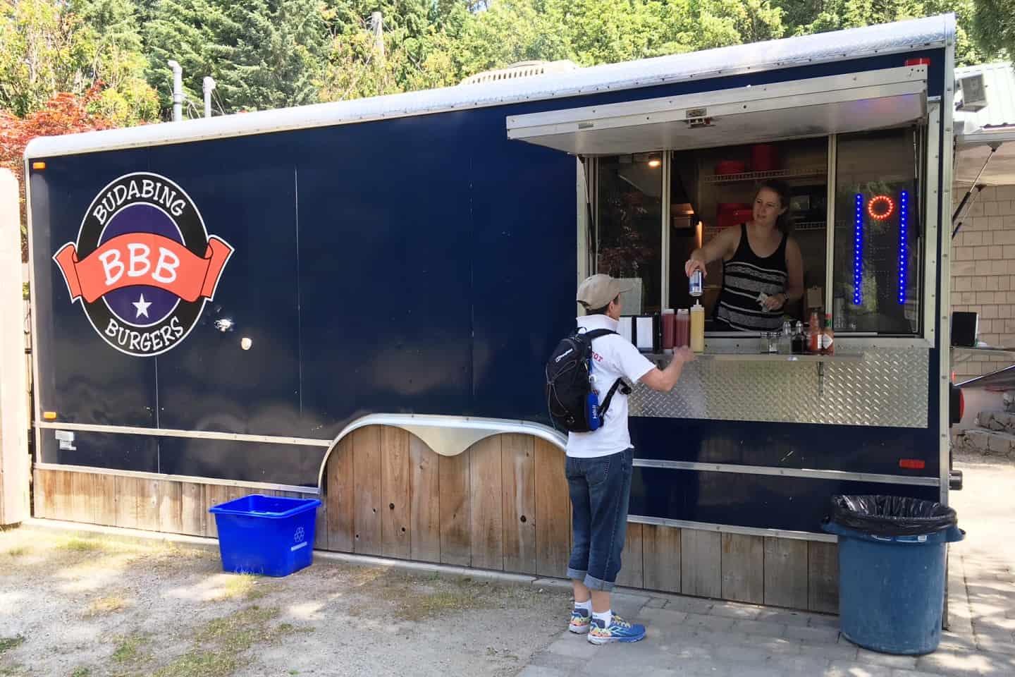
The Budabing stationary food truck in the little park at Madiera Park in Pender Harbour. It has the best fish and chips that we've found on our travels north. And they also have a great burger.
Don’t forget – you can click on any photo in the post to enlarge it.
Immediately after our arrival we saw the folly of skipping the shakedown cruise from Anacortes that we’d vowed to do after the long winter “on the hard”. When we lowered the dinghy into the water after the repair of two leaks from the sailboat incident last September, we knew something was wrong. As the keel kissed the water, from 12’ up where I was working the davit controls I could see water slowing filling in the bilge – and that spelled trouble. While the 3-point harness was still attached, Kap hopped in and I raised the dinghy out of the water so she could see what was going on before the weight of the water made it impossible to raise. She spotted water gushing in through the dinghy’s drain hole and the bung plug, and knew that it wasn’t seated. Normally we never remove the bung plug, but the repair guy must have, so looking for it wasn’t on our mental checklist. We won’t forget to check that in future!
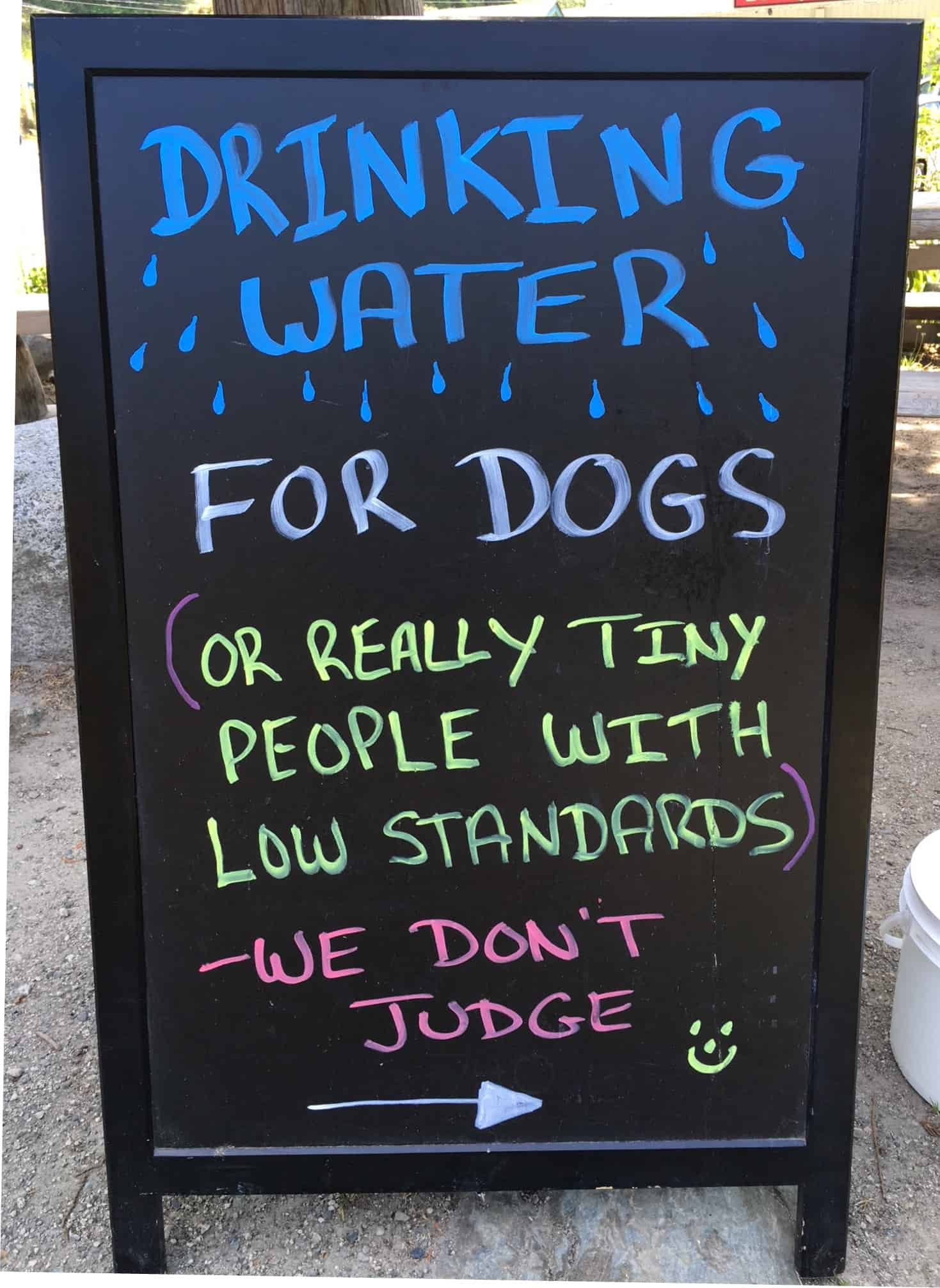
The guy who owns/runs Budabing always puts out a dog water bowl, plus a sign next to it each day that's worth a read.
As always, Roseanne Roseannadanna was hanging around again, as later in the morning when we got ready to make a trip over to Madiera Park for lunch and a bit of shopping, the dinghy battery was totally dead. Dang! We’d accidentally left the bilge pump running to get the water out of the keel area after the bung plug incident. Once we got there for lunch, and since the dinghy battery is almost 10 years old, we stopped at the marine service center at the Madiera Park dock to have a tester put on the battery to see if it was still in OK shape – it was.
Our freezer and fridge were still packed to the gills from our initial stocking in Anacortes and Sidney, so our normal supply run to the Madiera Park IGA was small and inexpensive. But it gave us a good excuse for a burger and fish and chips at the BudaBing food truck in the little park across the parking lot from the IGA.
If you want to see where we are now, or better yet, monitor our route progress as we cruise along, you can go to www.ronf-flyingcolours.com and click on the Current Location link in the upper right corner of the home page.
Also, this post is more readable in the online version, plus you can read any of the posts back to 2010 from the archive – just click on the link above to the blog.
After a good rest-up, we were itching to head north, so at 7:15AM on Sunday morning we slipped away from the dock and hoped for a good current going with us to speed our five hour cruise on the 50 miles ahead of us to the Cortes Bay SYC outstation. Early on, the seas weren’t as settled as we’d have liked, but as we got into the lee of Texada Island things quieted down and it was more comfortable.
The trip from Garden Bay to Cortes Bay is basically a long slog on the Strait of Georgia, which is 15-20 miles wide in most places, with a not very interesting shoreline and little of interest to see. The only hazard to navigation is the frequent ferry crossing between Powell River and Comox, with stops at the north end of Texada, and other than that it’s just five hours of droning on. For this day the goal isn’t so much the scenery along the way, but instead, the getting there.
We pulled into Cortes Bay just after noon, hoping that it would be as empty of SYC members as Garden Bay was. It wasn’t – by end of day the outstation was essentially full up, and any more arrivals would have to raft up to some other boat at the dock (allowing another boat to raft to you is mandatory at SYC outstations, as they are intended for maximum use by all club members. With our early arrival, we still managed to get an end-tie on the main dock, bow in to shore, giving us an unobstructed view from our cockpit deck looking across the bay. This also provides the most privacy, and everyone jockeys to get those spots.
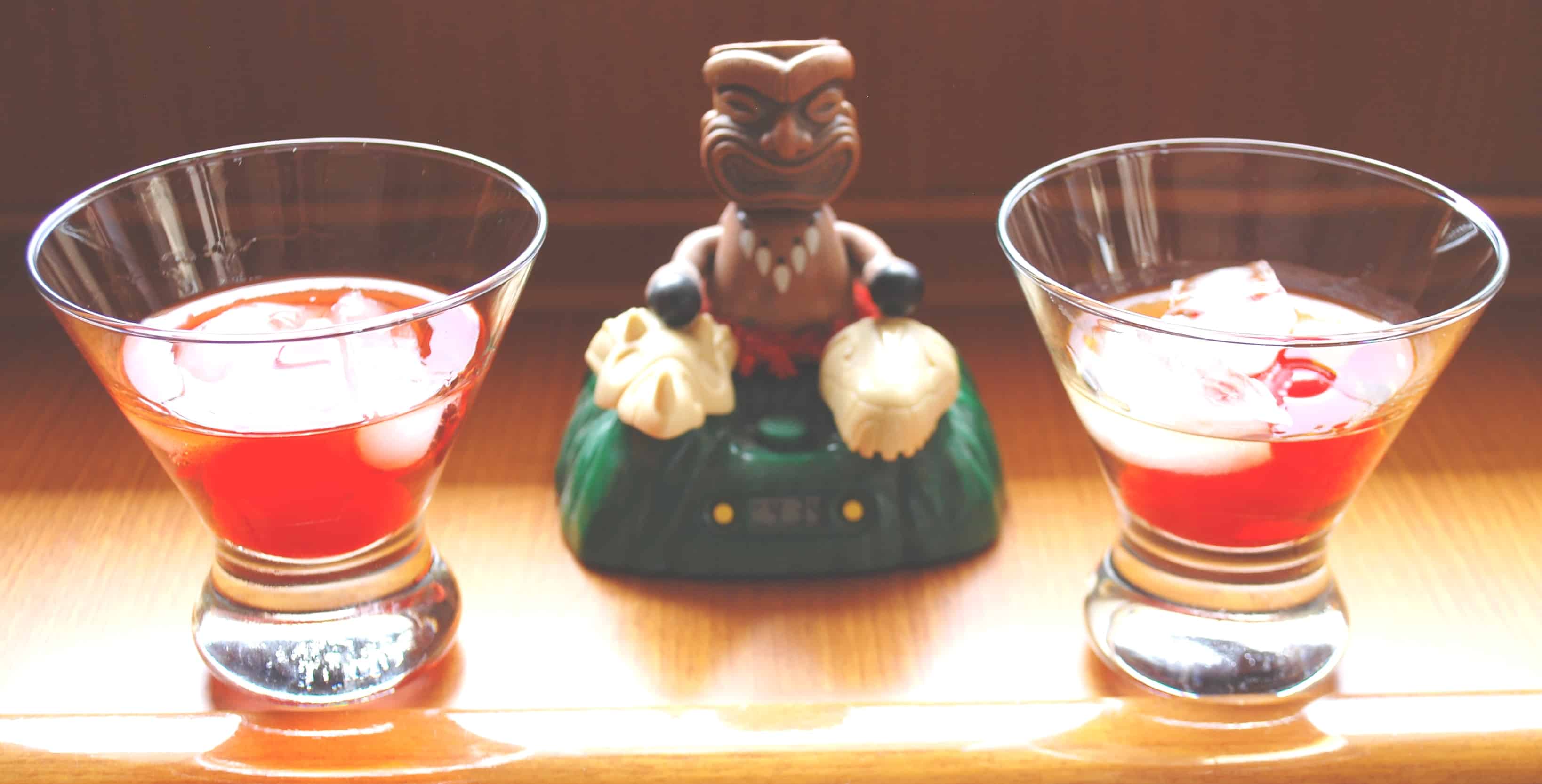
The Minky Monday tradition. This is a drink that Kap dreamed up on the Chick's Cruise in 2006, and along with the bongo-playing Tiki guy that we fire up to start the Happy Hour toast, this is one we have almost every Monday, on the boat or off. To get the recipe you'll have to joins us for a Monday Happy Hour sometime.
Minky Monday – a Tradition. A month after we sold our software company in July, 2006, our friends Paula and Jim invited us aboard Apt. 5, their 45’ Norseman 447 sailboat for a 3-week cruise to Desolation Sound. Previously, we had cruised with them on two bareboat charters (i.e., just us aboard, no hired Skipper), the first time in New Zealand’s Bay of Islands and the second in the Whitsundy’s on Australia’s Great Barrier Reef (both trips – what a hoot!).
For the upcoming cruise on Apt. 5, Jim would be finishing up a long work stint in Alaska’s Aleutian Island chain, not returning to Seattle until a week after the planned cruise start date. It was decided that their longtime friend, Dottie, would join Paula and Kap to deliver Apt. 5 to Nanaimo on a “chick’s cruise” and Jim and I would fly up on Kenmore Air to join them on his return (and Dottie would fly home).
During the Chick’s Cruise, after-cruising day Happy Hours were for good conversation, laughs, and to unwind. Throughout the cruise north, Kap – with her high level of energy – was constantly scampering around Apt. 5, doing this, that, and the other things. Paula and Dottie jokingly referred to her as a monkey. To commemorate the nickname, Kap set about inventing a new drink – to be called the Minky – a take-off on monkey, and because of the 2-3 maraschino cherries floated in it. Otherwise, the libation was all alcohol and meant for sipping, with an ounce or two of really good Canadian Rye Whiskey (which is Kap’s favorite spirit) and a float of Galliano.
Since that cruise, our tradition when we’re on the boat (and oftentimes at home too), we salute the chick’s cruise with a “Minky Monday” for Happy Hour. In any case, our Happy Hours are always announced by a Tiki God playing a pair of bongos on his knee(we have one on Flying Colours, and one on the bar at Cosmo Place (I named the bar at home after our Nordic Tug.
Tuesday, June 26; Cortes Bay SYC Outstation – Discovery Marina, Campbell River.
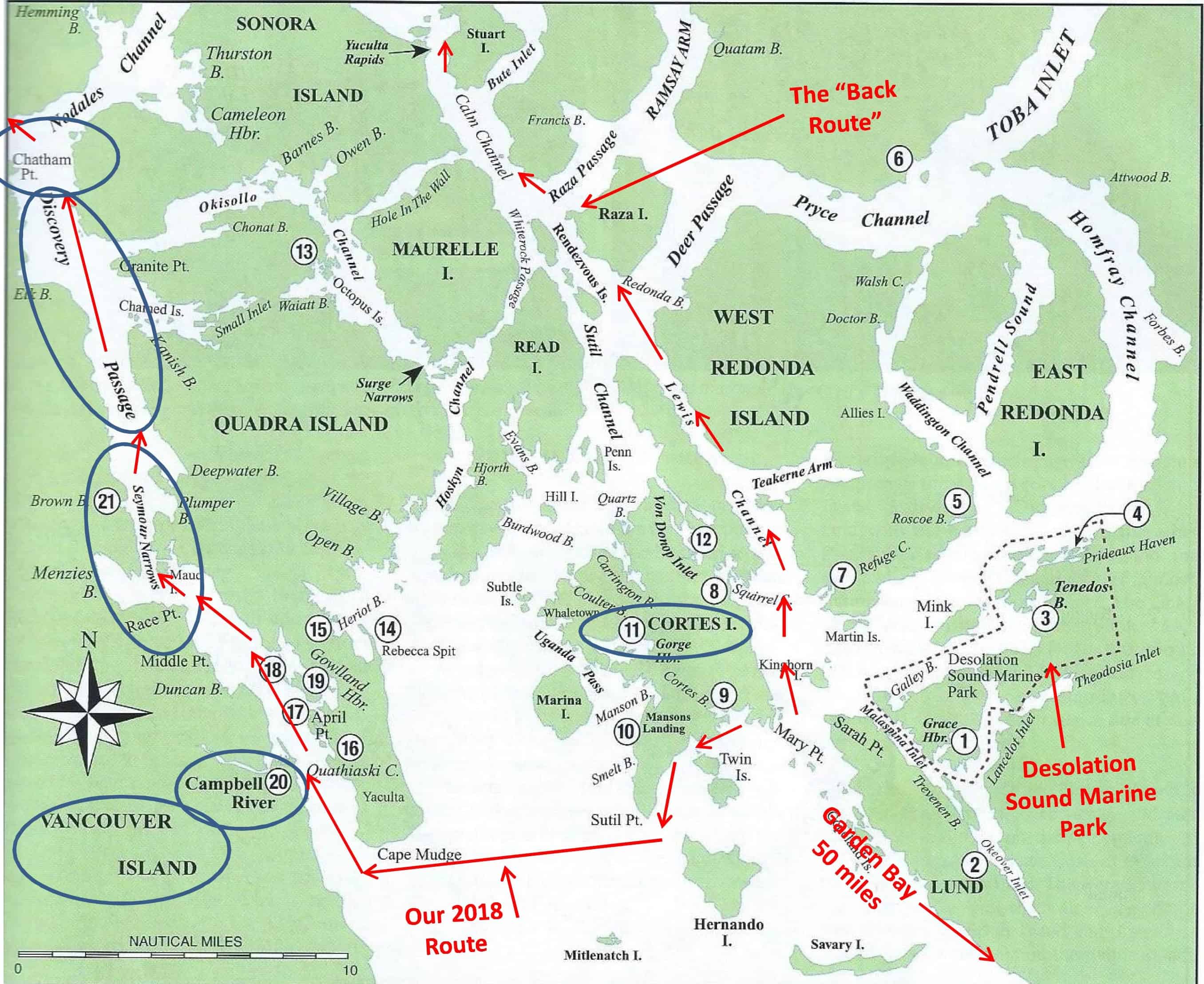
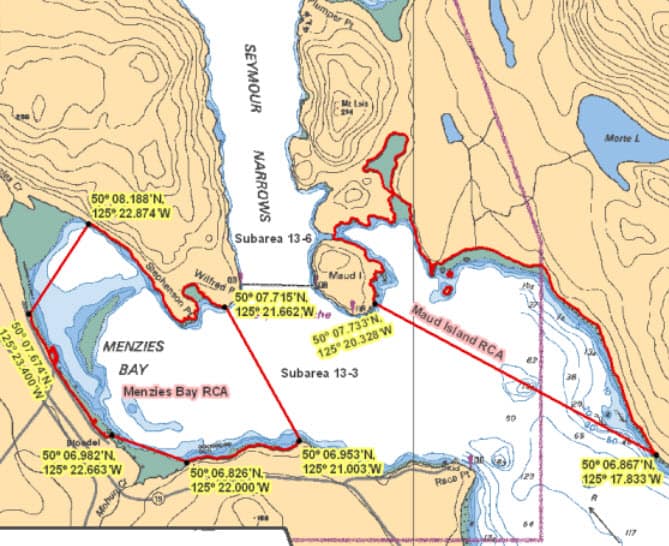
This is a good overall map of where we've been over the past several days. The lower left corner shows an arrow of our route up the Strait of Georgia from the SYC Garden Bay outstation to the Cortes Bay oustation (number 9). Our stay was cut short by Kap's tooth filling that fell out, causing us to make an emergency trip to Campbell River (number 20) to locate a dentist. From there we headed north on Discovery Channel, through Seymour Narrows, and then around Chatham Point onto Johnstone Strait. Ripple Rock is in the center of the channel through Seymour Narrows, and sets up some of the worst waters in all of the Inside Passage. Our destination for that cruise leg was Lagoon Cove at the lower part of the Brouthon Archipelago. I also labeles our "back way" up to the Broughton's, via the east side of Cortes Island on Lewis Channel, then Calm Channel, through the Yuculta Rapids (there are really three rapids in close succession there), past Dent Island (built as the Nordstrom family retreat, but now mostly used as a commercial fishing lodge), and then into Blind Channel for a night or two.
Cortes Bay is probably our third most favorite outstation. If it wasn’t for the flies and popularity among the other SYC members who crowd onto the docks, it would probably be our most favorite. By the entire club, it’s considered the jewel of SYC outstations, because it’s just an hour’s cruise to and from the incredible anchorages in Desolation Sound. Kenmore Air has a daily flight into the outstation, carrying passengers for SYC members who pick up or exchange guests. There’s a large (25’x25’) covered gazebo on shore where there’s often a “green box” for Happy Hour cocktails and appies (any member can “call” a green box, and club custom is that everyone on the docks shows up at 5PM, appies to share and a drink in hand). There are three club-owned cabins on shore that members can sign up for – and these are typically filled all summer long by members who drive up from the Seattle area to Campbell River, then first take the ferry across to Quadra Island, then a second ferry to Cortes Island to launch their small trailered fishing boats at the outstation launch ramp. There are multiple shower/toilet blocks out back of the club room, plus a laundry facility that members can use at no charge. In the past couple of years, the outstation manager has created a large herb, lettuce, and kale garden, and I always fill up a large grocery plastic vegetable bag for Kap’s salads before our departure.
On our second day at Cortes, Kap was munching a snack and suddenly found a very large filling that had dropped out of a tooth. After fiddling and fiddling to determine if the filling itself was still in one piece and that the hole it came from didn’t have an exposed nerve, she decided an emergency flight home for repair wasn’t necessary. She next pulled out our on-board emergency dental kit, thinking it might be OK to temporarily glue it in, but thought better of that.
Cortes Island is quite a large island (15×8 miles), but with a permanent population of only 1,000, its single (and tiny) dental clinic closes in the summer. The nearest “big smoke” is the good-sized town of Campbell River, 25 miles to the west on Vancouver Island.
Marv confirmed there’s nothing on Cortes but he highly recommended a dentist who recently pulled a tooth for him. Kap gave the dentist’s office a call. By now it was Wednesday, and noon on Friday was the earliest she could squeeze Kap in, but until she saw her she couldn’t guarantee anything.
The next big question was, what’s the best way to get to Campbell River. It wasn’t in our planned direction of travel, as we were heading north via the “back way”, and Campbell River would be a detour for us. There’s a regular ferry that runs from Cortes Island to Quadra Island (which is in between Cortes and Campbell River), but the Cortes ferry terminal is at a tiny village (actually, just a post office and ferry dock) at Whaletown, 8-10 miles on the other side of the island, and there’s no transportation whatsoever from the SYC outstation to get there (well, you can ride a bike, but it’s very hilly). Hitchhiking is common, but I was strongly against it, and besides, getting there to meet a ferry schedule makes it unfeasible. Worse, if she did take that ferry, it would get her to the east side of Quadra at a resort (I say “her” because I’d have to stay behind with ZuZu and Jamie) – and again, no transportation to the ferry terminal on the west side of the island. It could take the best part of a day to get there, and that didn’t make sense.
The decision was made to head across on Flying Colours on Wednesday morning.
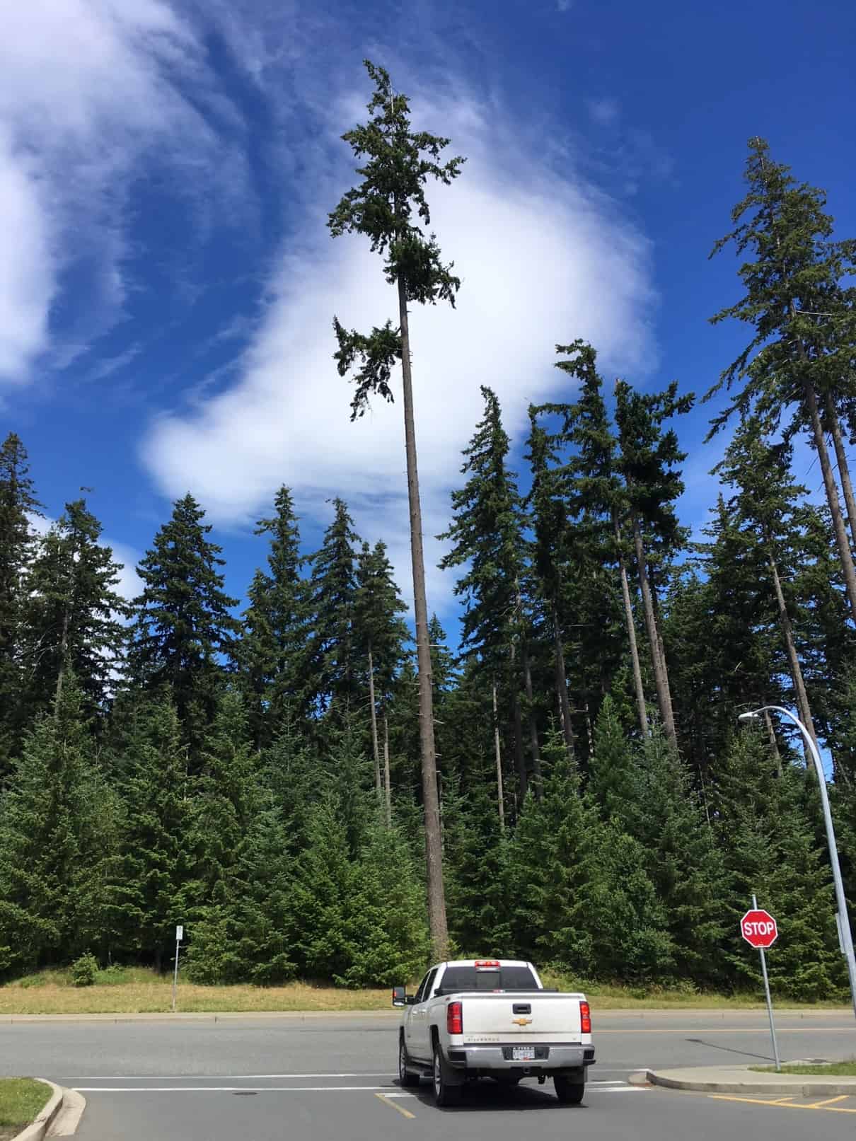
This stand of incredibly tall, perfectly straight pines (of some kind - Laura, do you want to offer an opinion?) completely surround the small shopping center on the southern outskirts of Campbell River where Kap located the dentist.
Our other challenge was where to get moorage at Campbell River. There’s a large, First Nations-owned and operated marina, Discovery Marina, very close to the downtown and shopping area of Campbell River. Back in our Nordic Tug days (2007-2008), this was one of our favorite marinas on our north/south treks through here, but since we got Flying Colours we haven’t been able to get moorage. The staff working the moorage office just doesn’t try very hard to accommodate cruisers, and even though there might be ample space available on the long side-tie docks, they’ll tell you on the phone or radio that the marina is totally full. We gave up trying several years ago, and if we need moorage on our way through here we now stop at April Point Marina, directly across Discovery Channel on Quada Island and then use their free shuttle boat to cross over. The trouble was, the shuttle docks 4-5 miles north of town at a sport fishing lodge, necessitating a taxi to get into town.
To our surprise, when we called Discovery Marina this time – and cleverly mentioned that we had a dental emergency – we got moorage for one night . . . but that was it. Anything further would be on a day-by-day basis, and we wouldn’t know until each morning if they’d let us stay. Nope, they still haven’t gotten any better. Getting onto the dock at Discovery Marina was just like old times.
Next morning we called to arrange a taxi to take us to the dentist office for the noon appointment. Our Google Map directions indicated it would be a 2-hour walk, and given the hills in between, almost as far by bicycle, so we knew a taxi was the only option. Good choice, but it was a C$25 (US$20) fare to get there.
After filling out what seemed like reams of paperwork, Kap got in to see the dentist, and the appointment lasted all of 10 minutes. She confirmed that the filling could be glued back in, but the overall procedure would take upwards of 40 minutes, and she didn’t have time before the next patient was due in. Kap agreed to a 4PM appointment later that afternoon. Being on the outskirts of town in a tiny shopping center that had no more than a half dozen shops, both of us waiting around for four hours twiddling our thumbs didn’t make sense (and ZuZu and Jamie were back on the boat). The only thing to do was buck up and pay for another C$50 round trip taxi ride. On the way back we had the taxi drop us off at our favorite Save-On grocery store that’s about a mile from the marina and we stocked up on the bit of provisions that we might need.
Kap returned for the 4PM appointment, and wouldn’t you know it, the gluing-in procedure took 10 minutes – and hells bells, there’s no reason this couldn’t have been done on the first visit. Oh well, the repair was done, and that’s what really mattered.
That night we had a wonderful dinner at the Harbour Grill that overlooks the marina – a great bottle of Burrowing Owl Syrah (a B.C. wine that’s extra good, but hard to find), plus salmon for Kap and Steak au Poivre for me. This is probably the best restaurant in Campbell River, and it directly overlooks the dock where Flying Colours was moored.
“ZuZu’s in the water!” About 9PM Kap and I were getting the moorage lines set up for easy untying for our very early morning departure. Kap was standing on the dock near the bow of the boat and I was just stepping onto the bow from the pilot house to take a line from her when I heard her yell out. I ran to the bowsprit to see where ZuZu was, and by the time I got there she had already paddled her way around the bow and was swimming between the boat and the dock headed for the stern – only to be stopped by the mid-ship fender that was tight between the boat and the dock. Kap managed to pull her onto the dock and then lifted her over the side of the boat and into the cockpit.
The water was really cold, and only being a 9 lb cat, she looked like a drowned rat with her fur all matted with salt water. We got her to the fresh water station at the transom door and hosed her off – if she tried to lick the salt water out of her fur she’d be sick as hell in no time. Kap reached inside the salon and grabbed a towel and we dried her off as much as we could. We then moved her to the warmest place inside the boat and got her calmed down from the fright of her fourth splashdown from the boat in her 10 years of cruising with us. (This is why Kap sometimes calls her Teabag when we’re on the boat.)
We have no idea why she went overboard – Jamie wasn’t anywhere near her, and the only thing we can figure is that she lost her balance on the slippery teak cap rail near the bow. Poor girl. When you’re only 8” tall, and going on 15 years old, a free fall of 10’ into 53° water must be terrifying. (I know from cold water scuba diving in Puget Sound that water this cold hitting just the small strip of exposed skin around your face mask – the rest of you is covered by a dry suit – almost knocks you out.)
Thursday, June 28, Discovery Marina – Lagoon Cove Marina.
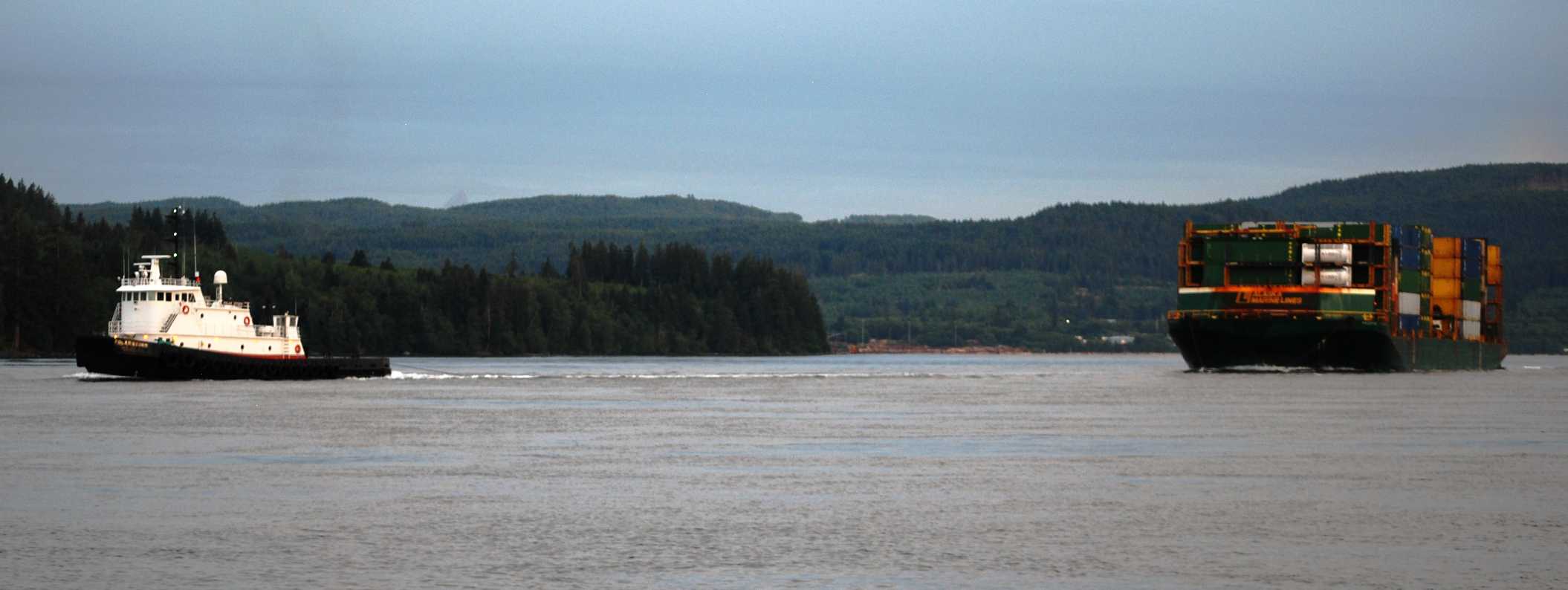
If you have to meet a tug and tow of this size along the route, the best place is certainly when the waterway is a mile wide - and not in the middle of Seymour Narrows. We've had that situation before and it wasn't comfortable. This time we met this Seattle-bound container barge a couple miles north of Campbell River, before Discovery Channel makes the S-turn into the Narrows.
Next morning I was up at 4AM – but Kap was already up at 3:30AM – for a daybreak departure from Discovery Marina. Heading north from Campbell River means passing through Seymour Narrows – it can be a very eventful passage even at slack – and slack was scheduled for 5:45AM. It’s just under an hour cruise from Campbell River to Seymour Narrows, so we needed to be away from the dock at 4:45AM. A quick breakfast for Jamie, then a short walk ashore to do her “bidness”, and we were away at 4:50AM.
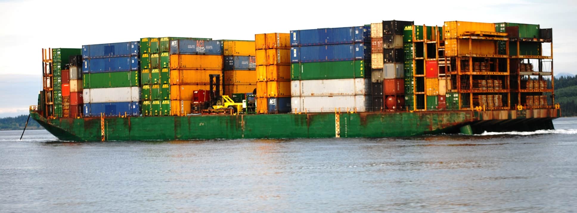
I used a bit bigger lens to get this close-up shot of the behemoth barge being towed past uss. We weren't able to catch the tug operator's company name , but the barge, with its green containers, is obviously carrying mostly Alaska Marine Line (AML) containers, which is a subsidiary of Lynden Transport out of Lynden (near Bellingham). This is the same shipping company that Western Towboat tows for, with their Pacific Titan tug that we've twice been to SE Alaska on.
Traffic at Seymour Narrows can be problematic, as it funnels tug and tows, commercial fishing boats, factory fish boats, and cruising boats, all into a narrow passage. And because of the whirlpools left over from the current running through at ebb or flood tides, everyone wants to be as close to the middle of the passage as possible.
This time, a U.S.-flagged tug towing a very large container barge came through to the south as we were approaching and wasn’t a factor for us. Several fishing boats and one cruiser were ahead of us, and that was all we contended with on this passage, making it quite uneventful. We have a saying on our boat – “if the passage is boring, we did it right”. Kap had to steer through several minor “whoop-de-doos” (whirlpools), but they were surprisingly benign – maybe even a first in more than a dozen passages we’ve made through Seymour Narrows.
The morning weather was cold, windy, and overcast, but with an ebb current running with us we had a “push” all morning long – traveling 11-12 knots over ground, and 8-9 knots through the water – so we were picking up a “free” 3-4 knots of speed. That made the 63 mile route to Lagoon Cove go pretty quickly (just under 7 hours total).
A close-up of Seymour Narrows. Coming up Discovery Channel there's a jog to the left and then right to position yourself to enter the Narrows. The trouble with that is, it means you're going into it sort of blind - with no way to really know who's coming the other direction. The big guys - like tug and tows - typically give a "Securite" call on Channel 16 to let opposing traffic know they're entering. One year in our early cruising days we had two commercial boats bass us right in the middle of the biggest whirlpool part - two abreast of us - and there was a tug and tow coming the other direction right at us. Kap was at the wheel that time, and I'm sure her knuckles were a bit white.
George Vancouver, Discovery Passage, Seymour Narrows, and Chatham Point. A little history lesson on this tiny part of the world might be interesting. In the summers of 1792-1794, British Royal Navy Captain George Vancouver sailed up the east side of Vancouver Island on what came to be known as the Voyage of Discovery – aptly named because he discovered, mapped, and depth sounded a helluva lot of coastal territory in our part of the world. It was an exploration that lasted three summers, reaching from the Seattle area in Puget Sound, all along Vancouver Island, the central and north coast of British Columbia, north to the SE Alaska border, and beyond that to Alaska’s Prince William Sound.
Vancouver’s lead ship was the HMS Discovery, at 99’ length, and with a crew of 100 – a very large ship in its day (by comparison, Flying Colours is 62’, and we feel cramped with a crew of 2 plus a dog and cat). On July 15th, 1792, Vancouver slowly cruised the same route we took this morning, naming the section between Campbell River and Chatham Point as Discovery Passage, after his command ship. As you can see on the nearby chart section, Chatham Point is the sharp bend in the waterway that turns westward into Johnstone Strait. Vancouver had passed through Seymour Narrows at 3PM (almost certainly at slack tide, but he didn’t mention it in his log), and was forced to anchor for the night at Brown Bay just north of the narrows, as the current was now running too fast against him to make any headway.
In his log, Vancouver mentioned that Seymour Narrows was “one of the vilest stretches of water in the world” – and yes, this guy had sailed the world, and he said this with good reason. Even at slack tide, in Vancouver’s day there was a standing wave across the Narrows that was dangerous to cross whether at slack tide or when the current was running full.
What’s with this “standing wave”? Simply put, it’s a stationary wave that doesn’t “flow on” like a normal wave, and it’s a true physics phenomenon. Without getting technical, the current through Seymour Narrows is so turbulent “to realize a Reynolds number of 109 (yes, that’s 10 to the 9th power, or 1 billion), and it’s estimated this is possibly the largest Reynolds number attained in any natural water channel on Earth. Turbulence normally starts to occur around a Reynolds number of 2,000, so a billion is a really large number. (Reynolds number is an important concept in fluid mechanics that describes whether a fluid flow is laminar or turbulent.)
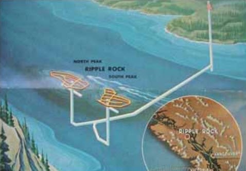
What an amazing dig! I've not seen anything written on how then tunneled - obviously it had to be big enough for a crew of workers to be doing the tunneling - and engineering the first 500' (or so) vertically down, then the last being a twin tunnel 500' vertically to get up to the area where they placed an unbelievable amount of explosives. This was a monumental effort!
Interestingly, Seymour Narrows isn’t all that narrow – it’s almost a half mile wide – but nevertheless, it’s a narrowing of very wide channel sections to both the north and south of it. Also, the channel is quite deep – approaching 500’, with steep-sided walls that drop steeply on each side of the channel. In the center of this deep channel is a two-pronged, incisor-shaped rock that rises almost the full 500’, to just 9’ below the water’s surface at low tide, with a North Peak and a South Peak. This infamous rock is known as Ripple Rock, and somehow Vancouver and his small flotilla managed to miss the rock on their passage. The Discovery would have had a keel draft of over 9’, but with a tidal change of as much as 14’, if they passed through at anything but a low tide slack, they would have passed over it without notice.
Over the next 150 years, though, upwards of 120 vessels weren’t so lucky, ending up at the bottom of Seymour Narrows as a result of Ripple Rock, and at least 100 people lost their lives. It was indeed a vile channel that became the most dangerous part of the entire Inside Passage.
With the Inside Passage being the primary transit route for commercial traffic, this dangerous situation with Ripple Rock was clearly untenable, and as early as 1932 discussion began to remove the rock. Many thought it was an impossible task, but in the early 1950s the Canadian government began serious research to blow it up. The details are too involved to write up here, but there are articles that describe it. Suffice it to say that they bored vertically (down) from the Quada Island side, then bored horizontally to the center of Ripple Rock, the bored two separate shafts vertically (up) inside each of the two peaks. They then packed it with 1,375 tons (yes, tons!) of explosives, and when they detonated it the blast was rated as one of the largest non-nuclear manmade explosions on earth. (Try Wikipedia, https://en.wikipedia.org/wiki/Ripple_Rock) for a description, and definitely take a look at a video of the actual explosion in 1958 (it was carried nationwide across Canada on live TV – and several YouTube videos from that coverage can be seen at https://www.youtube.com/watch?v=mYzaTZ232ts.
The result was to bring the two troublesome peaks down to a safe 45’-50’ below the surface at low tide, and well out of the way of any passing vessels. Nevertheless, the whirlpools set up by the tidal current running through Seymour Narrows and the remains of this incredible rock – even at slack tide – is still strong enough to whip Flying Colours from side to side like it’s a tiny stick in the water. We treat each passage with huge respect – and never know what to expect.
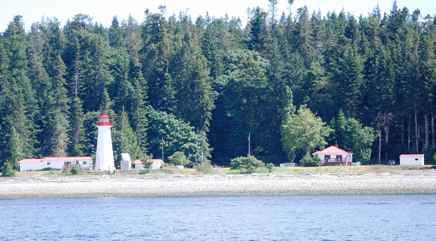
Chatham Point Lighthouse is always significant to pss, as turning left around it marks the entrance onto Johnstone Strait - the 50 mile segment of the Inside Passage that leads to the north end of Vancouver Island. Canadian coastal lighthouse stations are always scenic and a good photo op, although this one ranks fairly low in that category. They're always multi-structure, white with red roofs. They're also weather reporting stations, so we get very familiar with them via the VHF weather reports that are so important for us.
Chatham Point. Discovery Channel continues another 15 miles north beyond Seymour Narrows, until it reaches Chatham Point. As you can see with the accompanying chart, it’s at the confluence of three fairly major waterways, Discovery Passage from the south (that we cruised north on), Nodales Channel at 45° to the right along the NW side of Sonora Island (which we’ve never transited because there are more interesting ways to get to where it goes), and Johnstone Strait at 90° to the left – and at 68 miles it forms a major section of the Inside Passage. Our plan was to follow Johnstone Strait for its first 20 miles (or so), and then turn eastward at Broken Islands to make our way on Savannah Channel, then through Chatham Narrows, and up Chatham Channel to Lagoon Cove.
It’s surprising how many things around here are Chatham-this or Chatham-that. They are all named after HMS Chatham, a British Royal Navy survey brig that accompanied Vancouver’s 3-year expedition (the other reason it accompanied Vancouver’s command ship, HMS Discovery, was to provide armed support after the Munity on the Bounty incident). Her commander was Lieutenant William Robert Broughton – and the Broughton Archipelago where we cruise most summers is named after him. (Broughton returned to England before HMS Chatham sailed home, and another member of the expedition, Lieutenant Peter Puget, was given command of the Chatham for that ending to the voyage. Significantly, earlier in the voyage Puget was assigned to a rowing vessel that surveyed the area around what would become Puget Sound. (For anyone familiar with Puget Sound, what do you think about rowing around the entire Sound to survey it?) And, it’s just amazing how many other place names in the Pacific Northwest that are named after ships, men, and family of Vancouver’s Voyage of Discovery.
Passage, Channel, Strait . . . What’s the Diff?
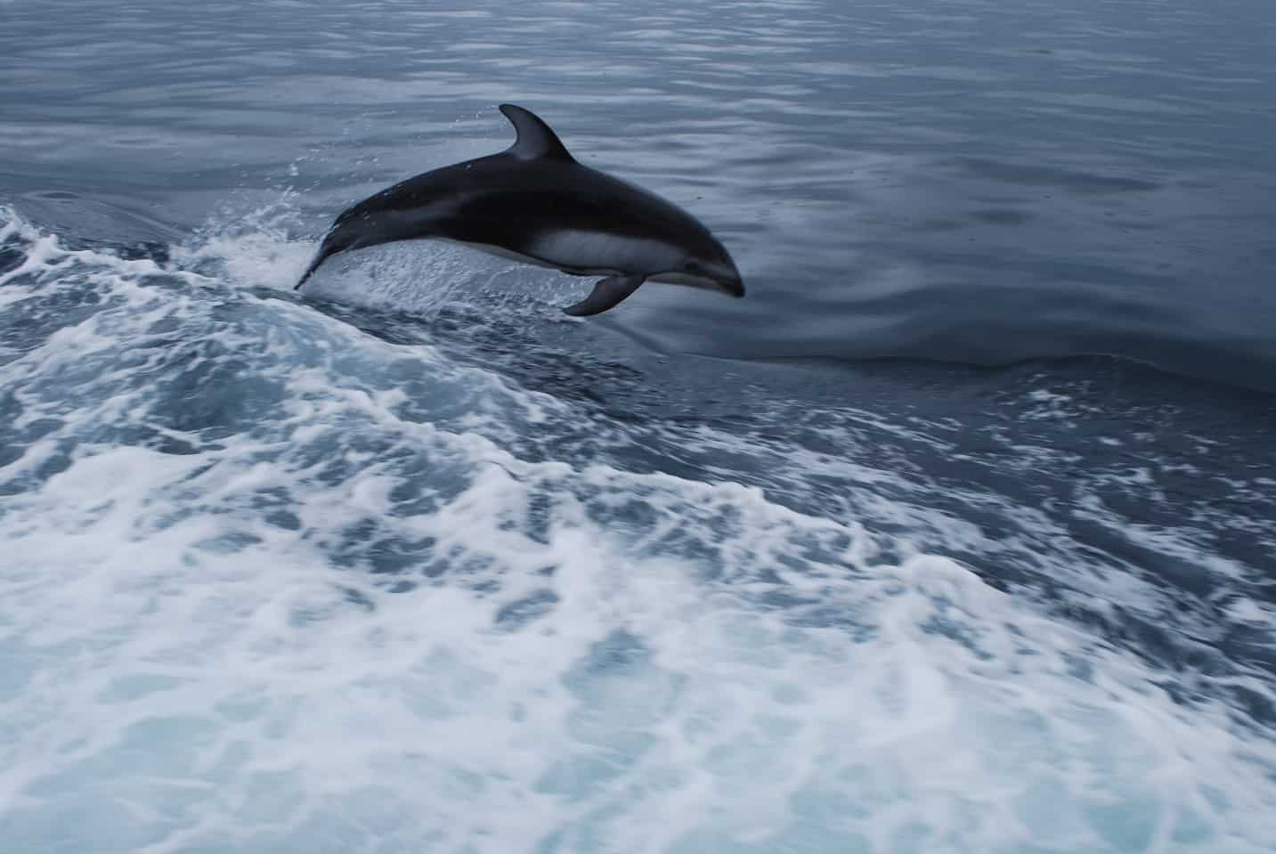
A group of frisky Dall porpoises came alongside just after we rounded Chatham Point. Normally, environmental regulations require that you stop (dead in the water) at the first sign of whales and other aquatic mammals around you, but dolphins intentionally seek out boats to have a romp along with them. There are always several in a pod that swim and hunt together (maybe a family group), and whenever you see their fins nearby you can bet they're coming over to you to surf on the boat's wake - either the bow or stern wake. This time it was the stern wake, and I immediately run there with my camera to catch a photo of them, exactly matching our speed, usually just a foot or soo below the water's surface, and once in a while jumping (like this one), maybe to catch a breath of air. Running in a pack, they take turns at the lead, most likely because they're drafting on each other to conserve energy. It often lasts for 5-10 minutes, and it seems like as long as they see you watching them, they're staying alongside. Maybe this helps them get to a hunting ground, or maybe they're doing it just for fun. Whatever . . . it's one of the best parts of any day when they form up on us.
Note that at Chatham Point it was the confluence of all three – a passage, a channel, and a strait. As far as cruisers like us are concerned, there’s little difference between them. To a cartographer, an oceanographer, or anyone who worries about exact terminology, there are undoubtedly small differences between each – where they lead to/from; length and width, and how navigable each is. But for our purposes, they are just a stretch of water that we can transit, and by doing so will get us where we want to go, hopefully with scenery for us to enjoy. FYI, there are Wikipedia pages when you do a search on “passage vs channel vs strait” that describe each and mention some of the differences. For us, they are mostly synonymous.
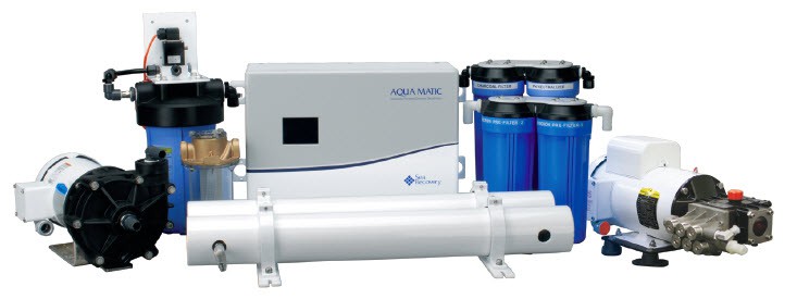
Here are the components that make up our reverse osmosis water maker aboard Flying Colours. It looks like a pretty compact system, but overall it takes up a good portion of the starboard side of the cockpit lazarette.
Fresh water aboard Flying Colours. It’s obvious to say so, but fresh water is essential – and it’s even more essential that the water is clean, tastes good, and is potable (which means safe to drink). We can refill our 300 gallon fresh water tanks on the dock at most marinas that we stop at. Filling with water is usually Kap’s job – using a special drinking water quality hose that she’s very fastidious about, plus she runs the dock water through a portable filter that’s hooked up in-line, just ahead of the 3’ stub hose that goes into our tanks. When Flying Colours was being commissioned in 2009 at Lake Union Yacht Center, we also had a “whole house UV and carbon filter” system installed that’s on “the other side” of the tank, filtering all fresh water as it’s pumped anywhere on the boat. And then just to be even safer, we also have water filters at every tap where we draw drinking or cooking water (an Instahot/cold tap at the galley sink, and at the water/ice dispenser on our galley fridge.
When cruising in waters that have reasonably clean salt water, we can also run our reverse osmosis water maker – a modular unit that’s installed in the boat’s lazarette (below the deck in the aft cockpit). Reverse osmosis filtration uses a semipermeable membrane that sea water (salt water) is forced through under pressure, removing the salt, bacteria, and most other icky stuff in the water – down to incredibly minute particles.
The unit aboard Flying Colours is a Sea Recovery Aqua Matic (Model 1400), where the model number means it’s designed (theoretically) to produce 1,400 gallons of fresh water in a 24 hour period. That amount, though, would be in absolutely ideal conditions (such as warm water, which we don’t have in the PNW). The unit is very automatic and usually easy to use, with a control panel on the pilot house dashboard. When it’s first activated, it starts a flushing process to clear the filtration membrane(s) and system lines, and then a continuously updated display tells us how much water it’s made. Salt water is brought in via an intake “thru-hull” at the stern of the boat, and the output goes directly into our fresh water tanks as incredibly pure drinking water.
As we came up Johnstone Strait a few days ago we ran the water maker for a bit over an hour and it indicated we made 98 gallons of fresh water, which is about a third of our fresh water tank.
Is it worth the $27,000 it cost to install the whole water maker and filtration system in 2009? Without a doubt, yes. Once we get to remote areas like the Broughton’s each summer, we’re either on anchor for several days at a time, and without it we’d be limited to how long we could stay. Also, we’re tied up at small floating “marinas” that sometimes have fresh water taps at dockside where the water source is from streams that flow down from high mountain lakes or snow melt runoff. If it’s tea-colored it’s called “cedar water” because of tannins in the water that create a colored water. The water at every marina is tested regularly by B.C. health officials and signs along the dock indicate whether it’s potable or not. Anyplace there’s cedar water we don’t take a chance, and instead, rely on our water maker. One time a few years ago we washed down our boat with dockside water at Sullivan Bay Marina in the Broughton’s, and within 15 minutes of spotting Raz, our adult Basenji, licking her feet after walking through some cedar water on the deck she came down with the nasty runs. Without delay we headed for Port McNeill where a vet diagnosed her with giardia.
This photo shows the Chatham Narrowsl range markers that are used to "sight" your correct position in the narrow channel. In this case we're going away from the range markers (there is a set on each end of the channel), so if the near marker is in the position you see now, you have to steer to the right to get the markers aligned. When they are exactly aligned you are in the center of the channel. It's really nice to have one person with binoculars sighting on the range markers while one drives the boat. The dredged (presumably) portion of this channel is so narrow that it doesn't take much to be off enough to kiss the bottom.
But back to cruising. We turned off Johnstone Strait at the Broken Island group, heading east towards Savanah Channel leading to Chatham Channel. It’s always an interesting challenge to go through the Chatham Narrows just before it turns into Chatham Channel, particularly when there’s always a concern that we’ll meet someone who doesn’t “share the road well”. (We once met a tug towing a wide log boom in the center of the Narows, and it was definitely a white knuckle meeting. We were already well into the Narrows when he entered, and you’d expect him to hold off until we cleared, but then, stopping a log boom is tricky business, so he probably had no choice but to continue on.) This time I was at the wheel taking Flying Colours through the channel and Kap got the duty of watching range markers through binoculars to keep us centered in the very narrow channel. The channel itself is at least 100’ wide, but only a half dozen feet deep outside of the centerline (presumably dredged) channel, so it’s imperative that you steer carefully by the range markers. We’ve never noticed that the GPS on our navigation screen is inaccurate through here, but there’s no way to know if it’s gone wonky.
The Blow Hole is the very skinny strip of dark blue (dark blue because it's very shallow - like 10' at low tide), and our GPS navigation screen indicates that we're just entering it from the east side. At right is Chatham Channel, and below the bottom of the screen is Chatham Narrows that we've just gone thrgough. Once we exit the Blow Hole, Lagoon Cove Marina will be on our left, just a few hundred yards around the corner on East Cracroft Island.
The last bit of tricky business getting into Lagoon Cove is a mile-long stretch that’s called the Blow Hole. Looking at the charts, no one in his/her right mind would ever take that route, but the former owner of Lagoon Cove, Bill Barber, always said it’s OK, low tide or high tide, so everyone uses it for getting in and out of Lagoon Cove.
Nothing much new at Lagoon Cove, but the atmosphere just isn’t the same without Bill Barber there, with his gruff persona on the dock, and his droll humor telling hilarious bear stories at each afternoon’s Happy Hour. (On our first trip to the Broughton’s in 2007, we encountered “bull rails” for the first time, for tying up at the dock. I’m a total klutz at tying knots, and was wrapping one of our lines around the bull rail to tie some kind of kludge knot. Bill saw what I was doing and said, “Don’t ever tie to a bull rail like that – do it like this”, and he proceeded to show me the “right way”. He was absolutely right, and I’ve done it that way ever since.)
The new owner and his crew are very nice, and they have lots of new marina logo clothing in their floating “emporium”, but otherwise, it’s just a good stopover on the way north or south. The new marina way back at the entrance to Savanah Channel from Johnstone Strait, Port Harvey Marina, is probably seriously eating into their business, giving anyone going straight up/down Johnstone Strait a shorter option to stop for the night. For us, we were hoping to do some nearby prawning, so that’s the main reason we went out of our way.
Saturday, June 30, Lagoon Cove Marina – North Island Marina (Port McNeill). As it turned out, the weather turned sour within a few hours of our arrival, raining hard for the next two days. With the temperatures still pretty low, the last thing we wanted to do was be out setting prawn pots in our dinghy in this weather. On the third day we tired of this and headed west, at first on Clio Channel, then transitioned to the very narrow and scenic 20 mile long Baronet Passage that separates West Cracroft Island (that Lagoon Cove Marina is on) from Harbledown Island on the north. At the western end of both islands, Baronet empties into Blackney Pass, with Johnstone Strait on the left and Blackfish Sound on the right. From there it’s a bit more than an hour into Port McNeill, where we’d called ahead for a moorage reservation as soon as we had cell coverage.
Everything we’ve heard along the way indicated that the commercial prawners – in their season that just ended two weeks previous – had all but cleaned out the prawn beds. We typically stop off at Booker Lagoon for a week of prawning when we’re in the Port McNeill area, but this year we decided to give it a miss. Instead, Kap focused on finding the last few things she needed for her budding salmon fishing hobby. While I inventoried and laid in provisions we’d need to head further north, Kap spent hours at the local hardware and chandlery stores in Port McNeill (these have taken the place of Army/Navy Surplus stores that she haunted in her younger days.
Sunday morning was spent doing laundry – not only our clothes but the bedding and towels too. We have a washer/dryer on the boat, but they’re small stack apartment-sized models, and being European (Miele) they have run cycles that are upwards of two hours long. Commandeering a bunch of washers and dryers in a laundromat is much easier and more economical of time, and the Port McNeill marina owner also owns the laundromat that’s just a half block from the top of the marina dock. Couldn’t be more convenient! As usual, while I watched the laundry, Kap and Jamie did a 5-mile run – the first since we’d left Sidney.
The day was one of our favorite holidays when we’re across the border – Canada Day (the other is B.C. Day). In the very small town of Port McNeill, though, while there weren’t any fireworks or mayor’s speeches, there was a parade – all of 30 people marching – starting at the street intersection just outside the laundromat. Heading it up was an oompa band of four musicians, followed by a row of RCMP in uniform, and ending with a row of war veterans. Following the marchers was the town’s fire truck and behind it the aid car. It was definitely small, but I still choked up as I watched them celebrate their country’s day.
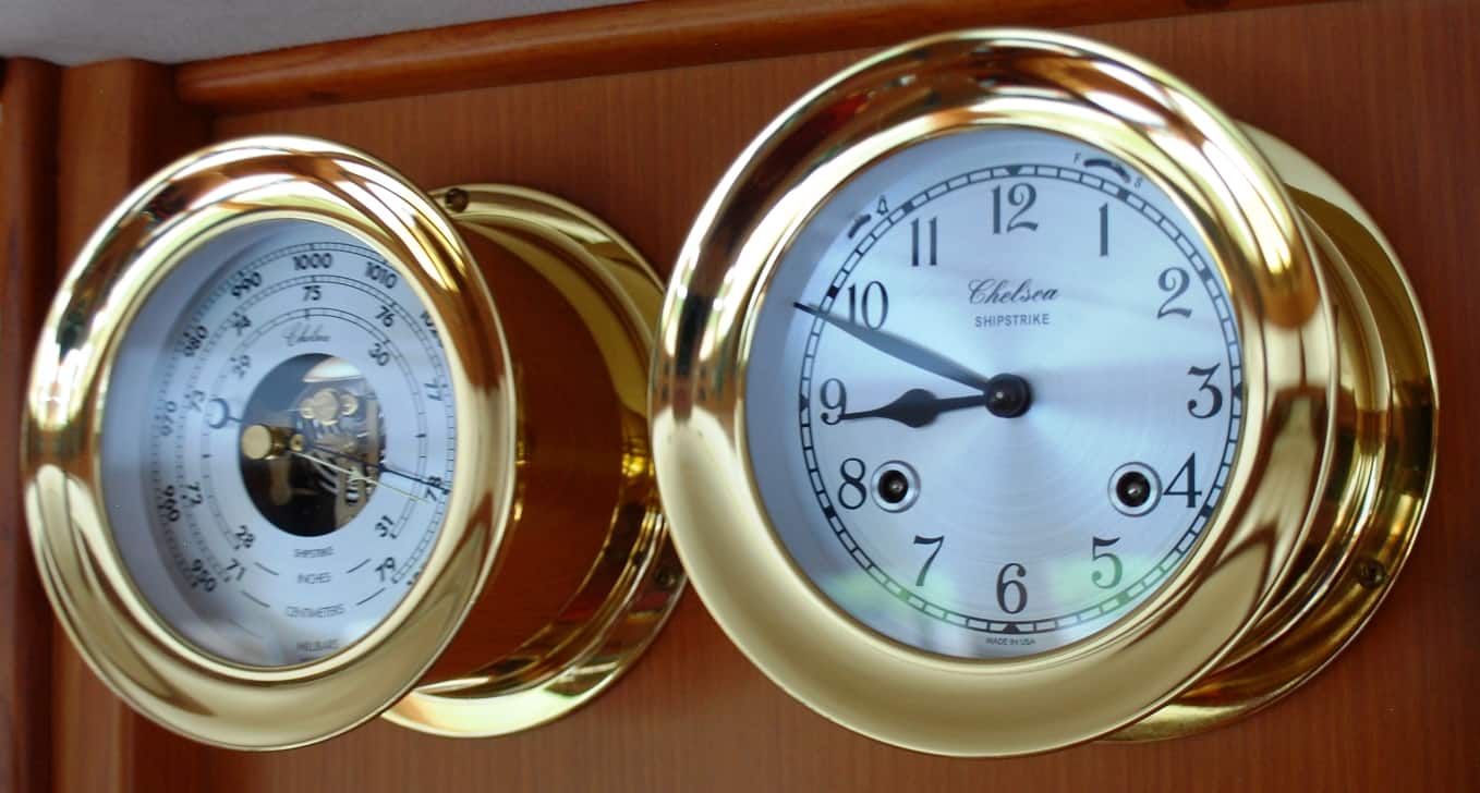 Ship’s Bells. When we outfitted Cosmo Place in 2007 (our 42’ Nordic Tug), Kap was adamant that she wanted a wall-mounted classic ship’s chronometer and a clock that rang ship’s bells on the hour and half hour. I too thought it was a good idea, and we purchased a Chelsea Shipstrike pair of fine instruments. The clock is an old-fashioned mechanical movement, requiring the clock and chime to be wound separately by hand every eight days. When we sold Cosmo Place and ordered Flying Colours we took them with us and mounted them in the pilot house.
It’s surprising how much we both enjoy the ship’s chimes, and we can hear them anywhere inside the boat, giving us the time without having to look at it. Well, not exactly – sometimes in the middle of the night I’ll hear it chime 5 bells, and won’t know if it’s 10:30 PM, or 2:30AM – and I have to pick up my iPhone by the bed to determine if I’ve just fallen asleep or if it’s the middle of the night.
Everyone’s heard the expression ‘eight bells’, but may not have a clue what the bell count corresponds to. Well, for mariners the day is broken into four-hour quadrants – midnight, 4AM, noon, 4PM, and 8PM. At each of those times the clock strikes eight bells, then each half hour and hour after that, starting at 1 bell, then 2 bells, and so on until it again reaches 8 bells (which signifies 4 hours have elapsed). So, if you’re working away in the morning as I am now and hear the clock chime four bells, you know it’s 10:00AM.
The origin of ship’s bells? As early as the 15th century a bell or gong was rung aboard ships to keep track of each half hour in a 4-hour seaman’s duty watch (the first recorded mention of its use was aboard the British Navy ship Grace Dieu in 1485). Of course, this is long before mechanical clocks and watches were invented, so an assigned ship’s boy had the duty of watching the hour glass and turning it when the sand had run out – and at that point he struck the bell or gong as a signal.
Wrap-up. For the first time in a long time we recognized that we wouldn’t be venturing into The Broughton’s. Instead, we’d head north from Port McNeill, around Cape Caution – and then who knows how much further north. We might stop at Prince Rupert, the last town of any size on the northern coast of British Columbia – just 50 miles shy of the SE Alaska border. Or maybe we’d strike across those 50 miles – called Dixon Entrance (for reasons I’ll explain if and when we get there) and make Ketchikan our last port of call. Maybe we’d go even further – as far as Wrangell or Petersburg. Maybe we’d cut it much shorter, stopping to explore the zillions of islands, bays, coves, and whatever, in the Shearwater/Bella Bella area. At this point, we weren’t sure what we’d do, and only time will tell.
Stay tuned.
Ron and Kap