
OK, two questions . . . #1, what’s a boat unit, and #2, what’s a house bank?
 Answer to question #1: A “boat unit” is a euphemism for the $1,000 shown at left, allowing boaters to refer to the amount of money being spent on various boat “things” that we can’t live without, yet don’t want to actually admit how much they cost. So if we’ve spent somewhere around two of these notes on some whatchamacallit, we just say, “well, that just cost us two boat units”.
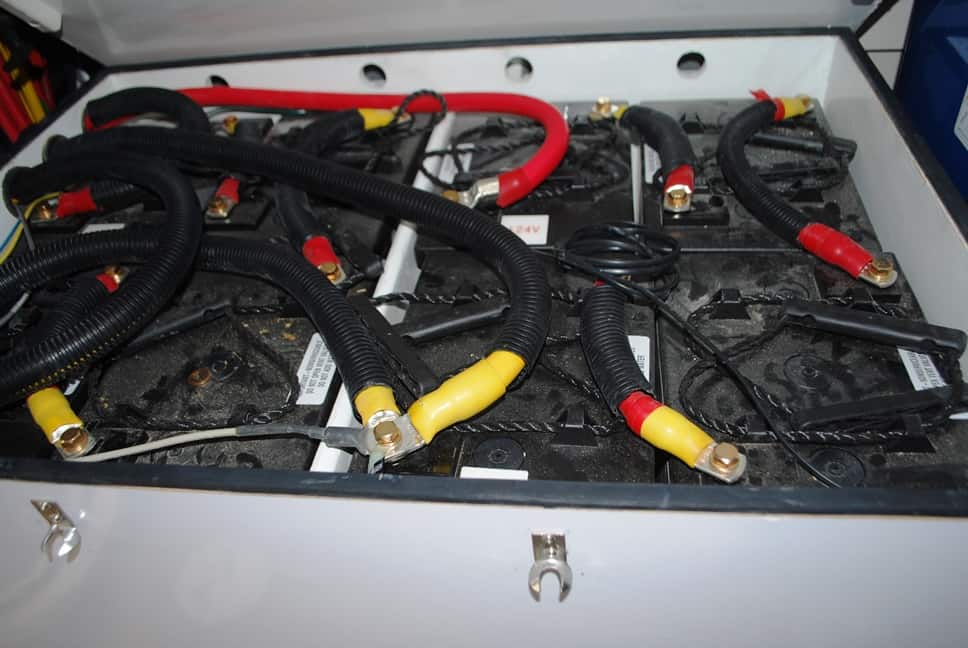 Answer to question #2: A house bank is something that you can easily “park” two or more boat units in. But rather than being a brick and mortar building at the street corner where you deposit your money, it’s actually a series of big herking golf cart batteries, ganged together with a snake’s nest of wiring, and providing electrical power to everything on the boat (i.e., the boat’s “house”) when you want to sit quietly at anchor and don’t want to run the generator (A different set of batteries, called the engine start batteries, handle the starting chores of the main engines, isolating that critical task from the fridge or DVD watching from running down the house batteries.)
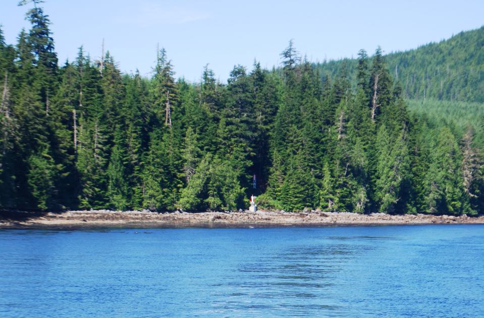
Now, having explained that, how in the world is it relevant to anything going on with Flying Colours? Simple, after five years of giving us really great service at anchor – for things such as prawning – our eight house bank batteries (shown above) gave up the ghost during our recent stay in Booker Lagoon. What’s ahead now for us is a 300 mile cruise southward to Delta Marine in Sidney, while we wait out a lead time of 10-14 days to have replacement batteries imported from Southern California.
(Remember, you can click on any photo to enlarge. Also don’t forget that the formatting of this blog post is better – everything lines up better – when you can read it online at www.ronf-flyingcolours.com – click on this link to go there. Also, if you’re logged into the post with your own userid, you can request an automatic update whenever a new blog post is put up – just click on the Subscribe link and enter your e-mail address. You cannot do this, though, if you’re logged in using the “friends” username.)
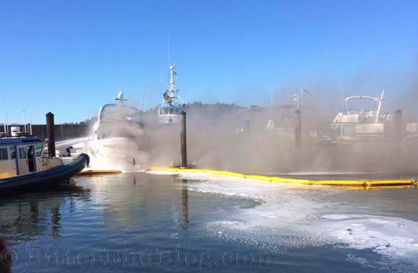 Holy Moly – News Flash, July 7. Anacortes Boat Fire . . . Total Loss. (photo source: http://bitterendblog.com/?p=21330. On A-dock at Anacortes Marina (the same dock as we keep Flying Colours), a 40’ Bayliner-type boat caught fire just 20 minutes before it was scheduled to depart on a charter cruise. The boat burned to the water line and sank at the dock. All of the nearby boats were moved out of danger, and there was no other damage. Although we watched the Seattle and Skagit Valley newspapers for the next several days, we saw no further news of it.
Heading South. After four days of waiting out strong winds throughout the north of Vancouver Island, on Friday, July 11 it was finally time to leave Port McNeill. The plan was to slowly head south, arriving in Sidney right around the time our new house bank batteries would arrive for installation. We’d have a full week, plus a weekend, so it could be a very leisurely cruise.
Given the timing, our further plan was to leave Flying Colours at the Delta Marine yard and make our way home for our long-planned two week mid-summer stay to get some non-cruising things done. Once the work was complete, we’d then return to Flying Colours for the last month of our summer cruising. With this change in plans, our thoughts after we return are to go around to the west side of Vancouver Island and spend the remainder of the summer in the Barkley Sound area.
We’d now cruised with Andrea and Steve on Couverden for a month, and with Andrea back in Port Angeles to visit her mother, Steve was holding down the fort on Couverden in Port McNeill. After one last Happy Hour with Steve the night before, we said our goodbyes (for now), and next morning departed the dock at 9AM.
Our only concern was with electrical power. In the normal course of things it’s easy almost to forget the importance of the house bank batteries. For the next week, the diesel generator would be our only source of power whenever we were away from shore power, and so we decided that anchoring out was not an option.
 Leaving Port McNeill, we motored south, first on Queen Charlotte Strait, which then transitions to Johnstone Strait. At the SW tip of Harbledown Island, Kap had plotted a short-cut route eastward through Baronet Passage, heading for the night’s moorage at Lagoon Cove.
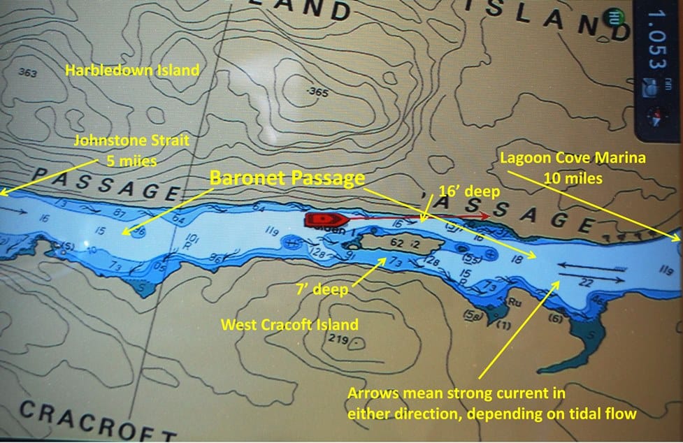 Baronet Passage is about 20 miles long, separating Harbledown Island on the north, from West Cracoft Island on the south. It’s barely ½ mile wide in most places, and very scenic. The most interesting part of it was at a tiny spot of land in the middle of the channel, named Walden Island, with a passage that’s 7’ deep on the south side and 16’ deep on the north. Kap wisely opted for the north channel (as you can see on the chart, it’s pretty narrow – about our boat length in width). The passage had been timed at slack, so the current was nil.
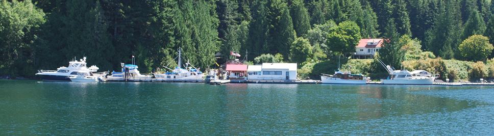 As we rounded the corner of Minstrel Island to Lagoon Cove, we spotted the familiar-looking marina that we’ve stopped at about two dozen times on our north and south routes to the Broughton’s.
As soon as we were in range, we called on VHF channel 66A to request moorage, and the welcoming voice of Pat, one of the marina managers, came back with directions, “Welcome back, Flying Colours, you’ll be on a starboard side Med tie, stern in, opposite the fueling side of the fuel dock”. (Med tie, in this context, refers to the way boats are typically tied up anywhere in the Mediterranean, where you’re tied only at the stern to the dock, and there’s usually a gangplank used to get on and off the boat.) In the photo above, the fuel dock extends outward from the red roof building (the marina office), and our moorage spot would put our stern directly in front of that building – which is great for us, as their 50A power source is available right off our stern. The only negative would be a stack of other boats rafted to our port side if it got busy, which is a bit of a pain in the patoot if we need to leave early in the morning to catch an o’dark:30 slack somewhere (it didn’t get busy, and we had no one rafted to us).
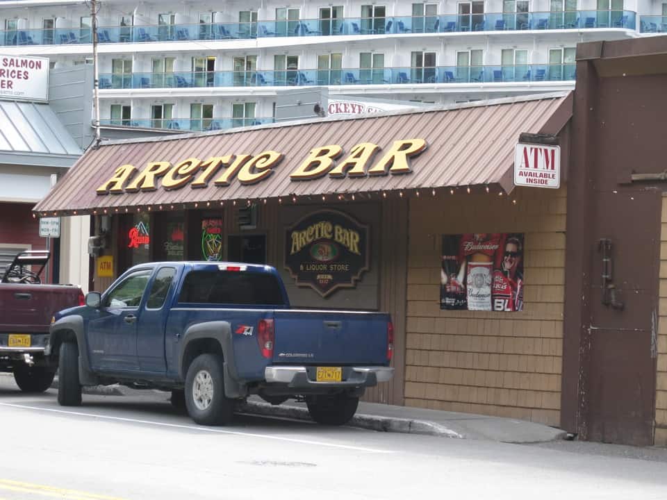
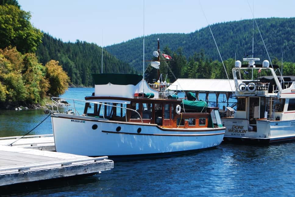 As we got closer, we spotted a familiar-looking classic antique wood cruiser to the right of our moorage position. I put the binoculars on it to see if it was the M/V Puget Lady (a wooden 1941 Ed Monk Sr design), owned by a friend from Port Angeles – and sure enough, it was the Puget Lady. The Skipper of the Puget Lady is Tom Magwire, who we met in 2008 on our way to SE Alaska. On that trip, we didn’t know until we arrived in Ketchikan that Tom is the co-owner of the Arctic Bar, a famous watering hole overlooking the downtown harbor. Tom’s ownership partner in the bar, salty-mouthed (but kind-hearted) Paula, runs the bar on a full-time basis, while Tom and his wife live in Port Angeles. He heads north on the Puget Lady every other year (or so) to help out with maintenance on the bar, but otherwise is a silent partner.
——————————————————————————————————————————————
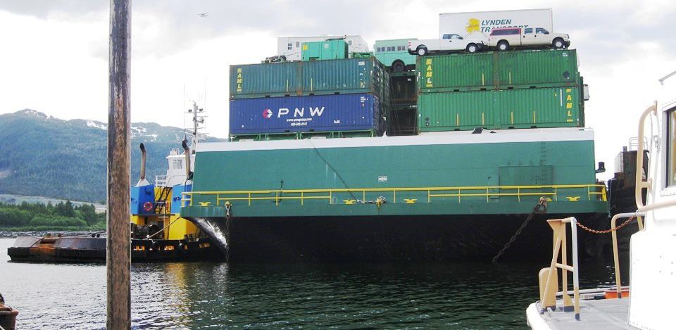 Back To July, 2008 For A Couple of Good Stories. (This is a big digression from this summer’s adventures, but it’s not been told before in this blog, so I might as well tell it here.) We’d no sooner arrived in Ketchikan and moored at a commercial fishing boat marina on the north side of town when we looked up and saw the Pacific Titan directly in front of us at the next commercial pier. It was side-tied to its barge, ready to unload a bunch of containers. We hailed the Skipper of the Pacific Titan, our friend Captain Doug Meyer, on Channel 16 and he asked us to come right over to the container pier (and after a big bear hug from him, he posed with Kap for a photo). Returning to our own boat, Cosmo Place, a Nordic Tug 42, Doug dropped by and
  we gave him a tour of our “toy tug”, which he thought was just perfect for cruising.
(For those of you who don’t know (or don’t remember), I was aboard the Pacific Titan in 2003 for a “tug and tow” cruise from Seattle to SE Alaska, and it was the first time I’d met Captain Doug. The trip was so incredible that we arranged for both Kap and I to make the voyage a second time in 2006, again with Captain Doug at the helm. We still talk to him via VHF radio calls (or text messages) at least once or twice a summer when he’s passing near to us on his every other week trip from Seattle to Ketchikan, Petersburg, Juneau, Haines, and Skagway, pulling a 350’ barge loaded with 700+ containers with his 105’ long tug.
During my 2003 trip, while the tug guys were unloading containers at Ketchikan, I walked into town and had a beer at the Arctic Bar, and of course bought an oilskin waterproof cap showing the famous Arctic Bar logo of two very happy bears – I won’t show it here, but you can see it at www.arcticbar.com.) In the accompanying photo of the Arctic Bar, the huge hotel-looking building shown behind (with rows and rows of glass doors) is a cruise ship at the dock in front of the bar.
 That evening, Kap and I arranged to meet up with two other cruisers (we buddy-boated with them almost all of the way from the south) for a hamburger and beer at the Arctic Bar – Bucky and Christy Wood (Bucky is a retired surgeon from Birmingham, AL) on their American Tug 41 named Undoc’d – good name for a retired doctor, huh? – and Marty and Linda Ellison on their Nordhavn 55, named Tenacious. To our surprise, barmaid Paula was hosting a benefit “dessert auction” that night in the bar, and quite a night we had! Besides all of us drinking a lot more beer than we’d planned, Bucky was the life of the auction, buying seven pies for something over $1,000 (how he found room for them on Undoc’d is beyond us!). The auction was to raise money to build an Arts and Humanities Center for Ketchikan, and with everyone’s generosity that night, the final money was easily raised. (Paula was named “the heart of Ketchikan” by the Chamber of Commerce for the frequent charitable events she sponsors.)
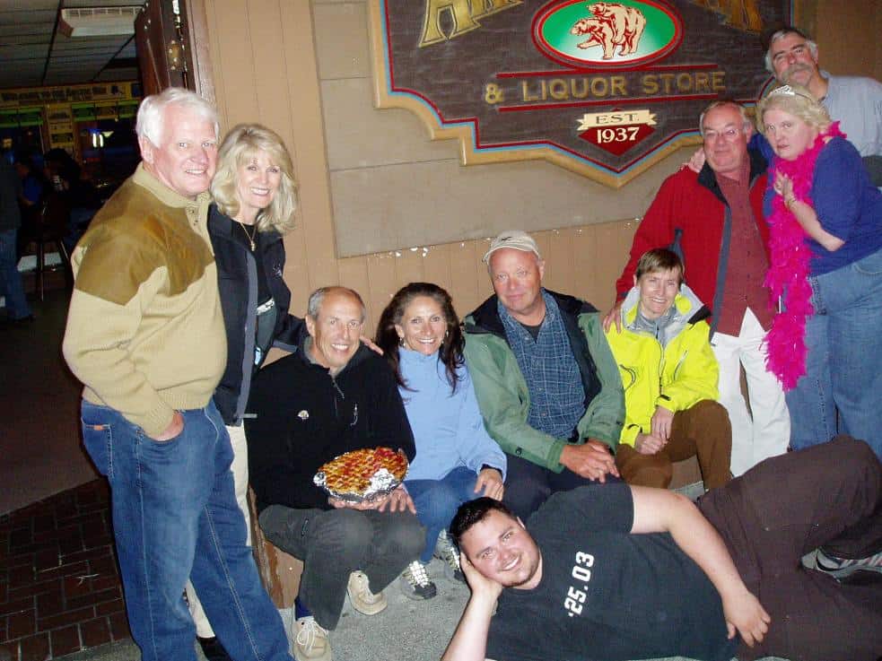 A highlight of the evening’s affair was after the auction ended – the six of us joined with Tom and Paula to become founding members of the Arctic Bar Yacht Club (which, unfortunately, never got off the ground after that night. In the accompanying photo, Kap is in her yellow arctic coat, I’m behind her with Paula’s arm around my neck. Tom Magwire’s head is peeking over Paula’s head. To Kap’s right is Kevin Craig (one of Tom’s best friends), then Christy and Bucky Wood (and Bucky has one of his prized pies in his lap), and at the left is Linda and Marty Ellison. Lying on the floor in front is Tom’s son.
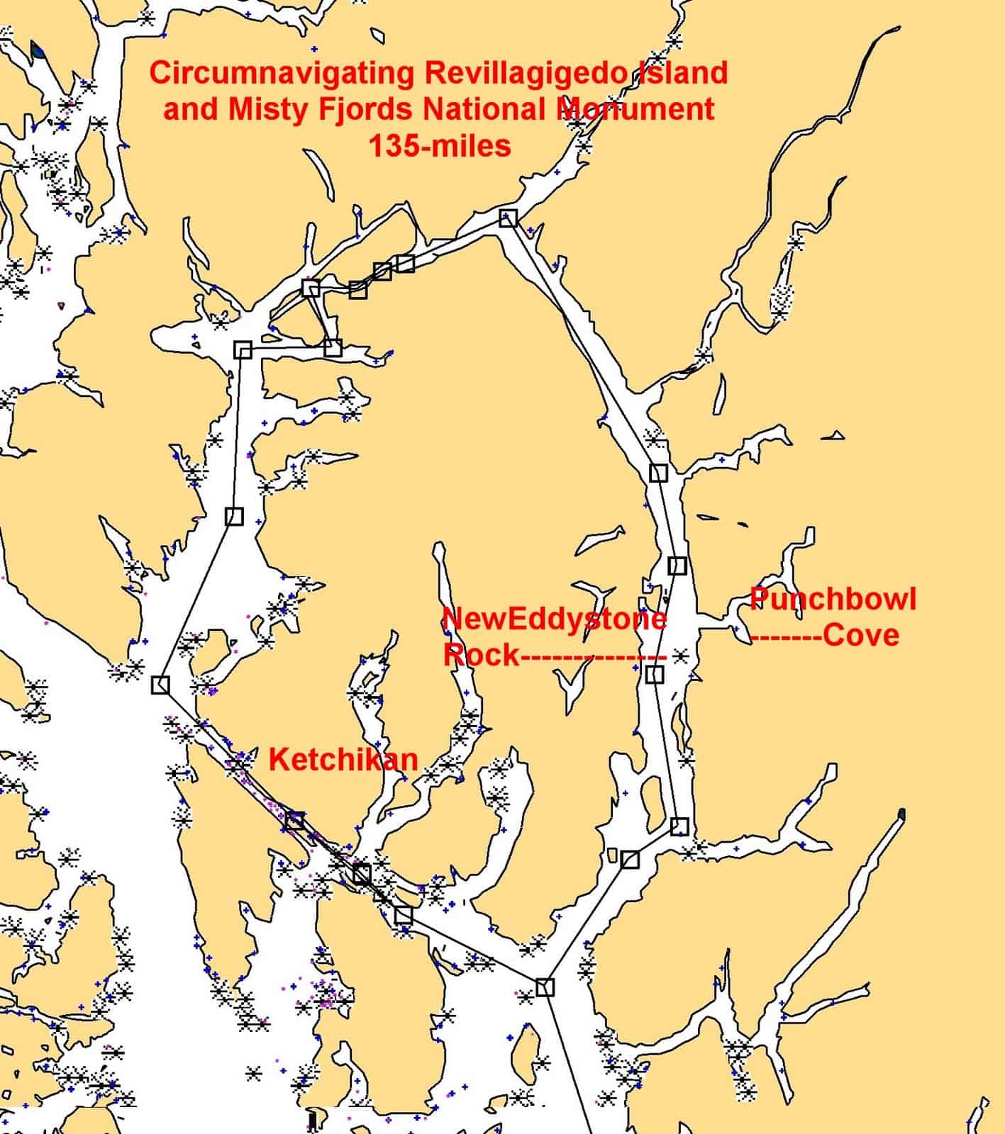 After spending almost a week in Ketchikan, Kap and I circumnavigated the trapezoidal-shaped Revillagigedo Island – Ketchikan is on the southwest side of the island – and our primarily reason to visit Misty Fjord (east of New Eddystone Rock, where the map shows Punchbowl Cove). For some reason, Misty Fjord is a beautiful area that’s typically bypassed by most cruisers. After rounding the south end of “Revy” (as the locals call it), we spent a wonderful 2-3 days in Misty Fjord, then another day cruising up the eastern side of Revy along Behm Canal – 3/4ths of the island is surrounded by Behm Canal. (It isn’t intuitive how to pronounce the island’s official name – it’s “revy’-ya-jig’-eh-doh”. It was named by Captain George Vancouver during his exploration in 1792, in honor of Juan Vicente de Güemes, 2nd Count of Revillagigedo and viceroy of Mexico (which, by the way, was called New Spain at the time). It’s not often we get Spanish-named cities and islands this far north, and this one just doesn’t trip off the tongue. Anyway, Revy is 50 miles long from north to south, and about 35 miles wide east to west, making it the 12th largest island in the United States. Until this trip, I had no idea – actually, never thought about it, really – that Ketchikan was on an island . . . I figured it was simply on the North American mainland.
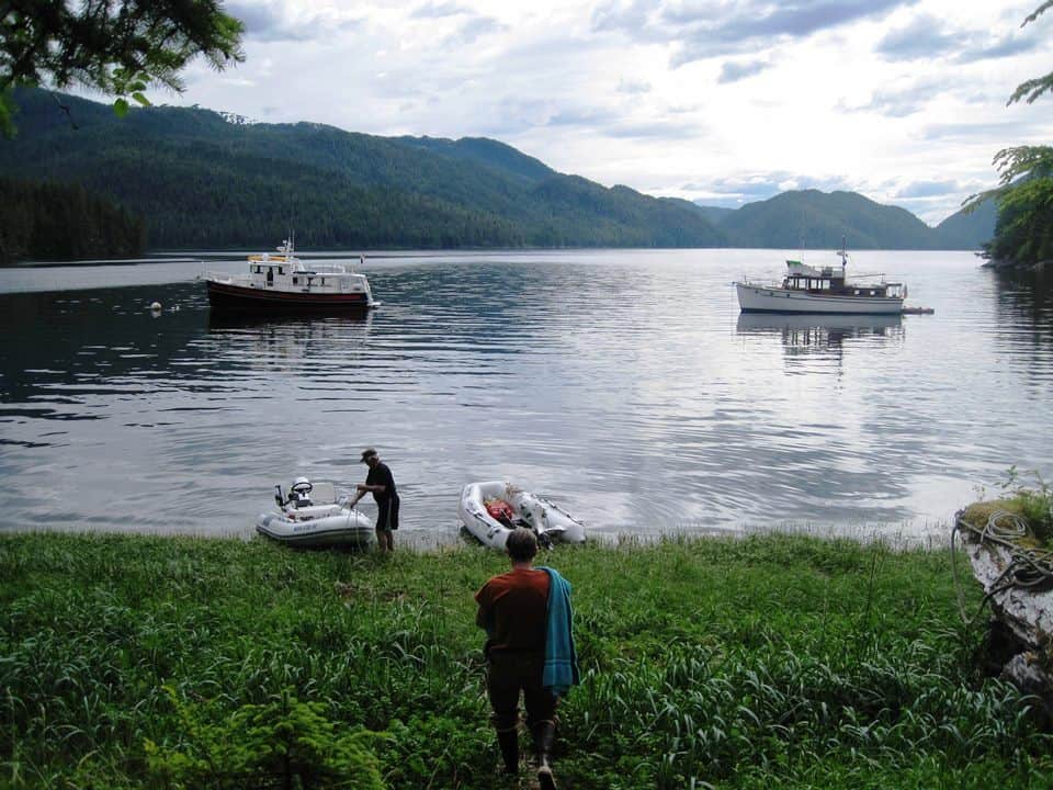
Before leaving Ketchikan, Tom Magwire mentioned that we should drop into a tiny hook bay called Claude Point at the very top end of the island. He said he and a friend were heading there to a cabin they’d built some years earlier as an overnight refuge for kayakers who needed a place to shelter. They’d be there for a few days to do some necessary maintenance on the shelter, plus get some quiet kayaking in. We figured it might be a good place for us to anchor, so Kap and I were eager to check it out.
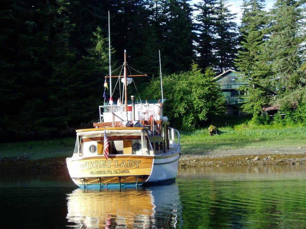
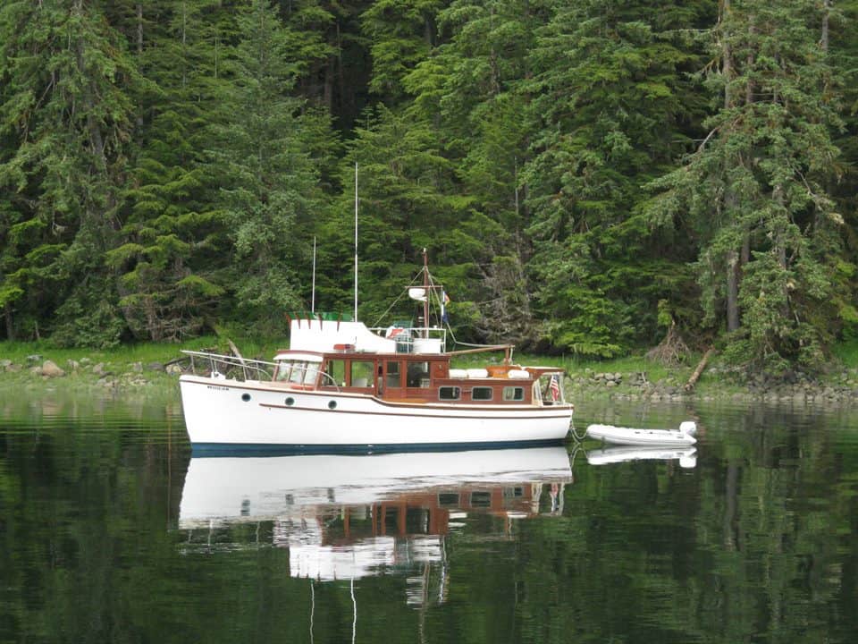 As we turned around Claude Point, we saw Puget Lady at anchor in the sheltered waters of this wonderful little bay. On the shore was a building tucked into the trees that must be the kayak shelter Tom mentioned, but there was no sign of anyone around, not on the Puget Lady, nor ashore. We dropped our anchor about 200’ from Tom’s boat and waited to see if anyone showed up. In the photo below that shows the shelter with the beautiful varnished stern of Puget Lady, note the “home port” of Puget Lady – Claude Point, Alaska.
Sure enough, about an hour later two kayakers came into view on the point at the entrance to the bay, and we could see it was Tom and his friend, Kevin Craig. We dinghy’ d ashore and the four of us had a great glass of wine (plus ZuZu, who also had a great time exploring the open ceiling rafters of this primitive shelter). The place was pretty disheveled, but out in this wilderness area we were not complaining.
 The background on the shelter is rather interesting. Tom and Kevin (plus a couple of other volunteers) built it several years earlier (Tom was a building contractor in Ketchikan at the time, and Kevin was a dentist – and both were avid kayakers). The property was on government land, and there was a broken down old single story trapper’s hut where the current shelter is located. They used this hut as a shelter on some of their kayaking expeditions, and figured other passing kayakers could make good use of it during wild weather that comes through the area. Somehow a lease was secured for the acre the shelter sat on, but before they could do any fix-up on it the surrounding area was annexed by the National Forest Service and they were told to vacate the property. With some quick researching of the regulations, they determined that the lease on the existing shelter and land gave them rights to remain, so long as they kept the lease in force – but they were prohibited from building any new structures, or tearing down any existing structures (the lease costs around $1,000/year, and they just pay it out of their own pockets, and leave a sign up that says anyone can use the shelter). With some clever thinking, using their small runaround boats, Tom and Kevin hauled every piece of material from Ketchikan that was necessary, and proceeded in their spare time to construct a proper two-story extension above the original shelter (you can’t see it in the photo, as the greenery has grown up to almost cover it). There was no way that the original shelter could support this, so they left it untouched and built the new addition on pilings on the outside of the original shelter – and that way, they satisfied the new building prohibitions. So far, they’ve managed to fend off the National Forest Service, and Tom confirmed when we saw him two weeks ago that the place is still in use as a kayak shelter.
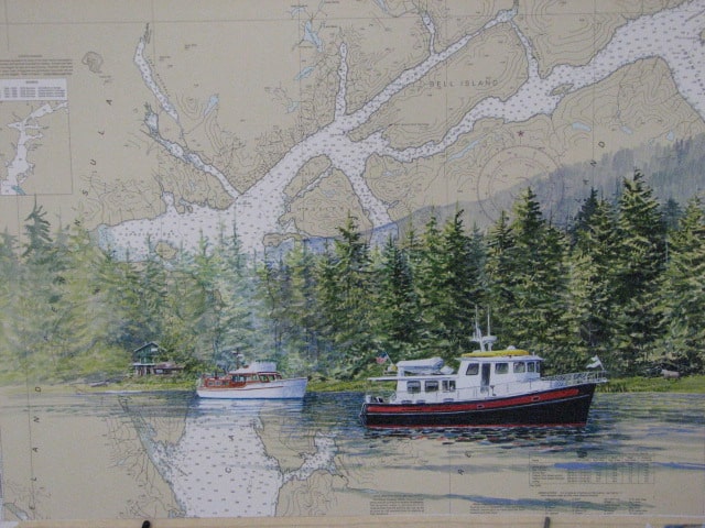 A few days later, we chanced upon a watercolor artist in Wrangell (about 50 miles north) named Brenda Schwartz-Yeager – and quite a character she is. A fourth-generation Alaskan, and retired from commercial fishing, Brenda is owner/operator of a charter boat that takes clients to the areas she paints. Her specialty is watercolor on actual marine charts (maps to landlubbers). Sending her a collage of about a dozen photos of Cosmo Place and Puget Lady, plus the shore scenes of Claude Point, I asked Brenda to paint a scene on a marine chart of Revi Island, showing how it looked with our two boats anchored offshore from the kayak shelter. The background chart that you can see in the painting shows the top end of Revillagigedo Island directly above Cosmo Place, and that little “hook” on the top side of Revy is Claude Point. The watercolor Brenda created is absolutely fantastic, capturing from the collage of photos, an incredibly realistic scene of Cosmo Place anchored with Puget Lady in the little bay inside of Claude Ppoint.
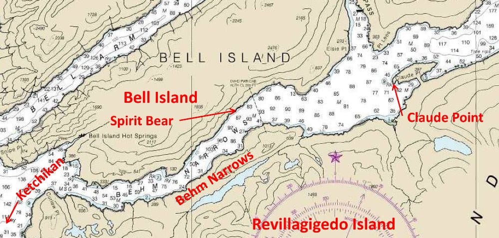 But back to Claude Point . . . and the rest of the story. In the NOAA marine chart at left, I’ve sectioned out that area, showing exactly where Claude Point is. As you can see in this detail, the location where the kayak shelter is located is on a very narrow isthmus that links what would otherwise be an island to the main part of Revillagigedo Island. We anchored with Puget Lady in the sheltered waters in the bay on the left side of the isthmus.
Early next morning, Kap and I pulled up our anchor and continued our circumnavigation of Revillagigedo. Our route continued west along the top of Revillagigedo Island, with Bell Island on our starboard and Revy on our port side. The waterway narrowed as we entered the S-curve at the beginning of Behm Narrows. Kap was at the helm, and had positioned us almost exactly in the center of the channel – which is about 1/4 – 1/2 mile wide. I was standing next to her in the pilot house, casually scanning the shore on our starboard.
Suddenly, I saw a rock move! Wait a minute, idiot! Rocks don’t move! I looked more closely, and saw that some animal, white-ish in color and on four legs was slowly ambling along the water’s edge. At our distance, it was impossible to see what it was, but putting the binoculars on it I could easily tell it was a spirit bear! I grabbed for my camera – a point-and-shoot Canon PowerShot digital camera, totally inadequate for the task at hand, but it was all I had at the time. As Kap edged us closer to the side of the narrows, I snapped a dozen photos, but with the pitiful zoom lens on the camera, my “moving white rock” was barely perceptible (can you see it in the untouched photo of the beach – this is the first one I took after spotting him – he’s down by the water’s edge, just to the right of center). I’ve included here two “untouched” photos from my pitiful little point-and-shoot camera, and with each one I used Photoshop to electronically zoom in on the digital image without getting too blurry, and you can definitely tell it’s a spirit bear.
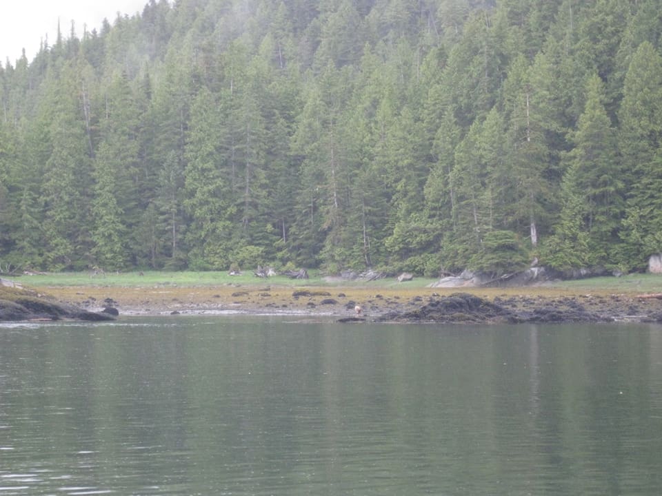
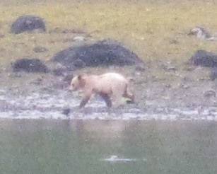
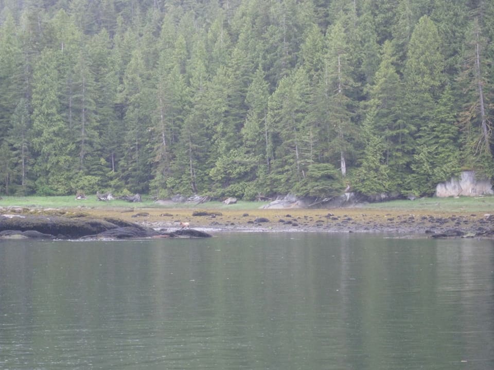
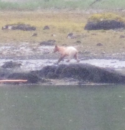 With Cosmo Place’ main engine in idle, and moving at our slowest possible speed, we watched the bear amble along the beach, maybe looking for a fresh oyster snack for breakfast, or maybe he thought a salmon would just jump up on the beach for him to grab. He gave no sign that he saw or heard us, but, as he moved towards the rock outcropping on the left he appeared to be finished with whatever he was doing at the beach. Slowly, slowly, he wandered behind the rocks – and I thought it was the last I’d see of him . . . but then he appeared again, still just wandering ever so slowly. Finally, something spooked him – maybe he caught sight of us, maybe he heard our engine – and he scampered up the rocky beach and into the trees.
Unbelievable! We’d been on the lookout for a spirit bear (known officially as a Kermode bear) since entering the Northern B.C. coast area two weeks earlier – between the tiny First Nations village of Klemptu and Prince Rupert – as that is reportedly the only place where spirit bears supposedly live. There was certainly nothing in anything I’d read about them being this far north. Here’s a typical quote about their habitat: “The kermodei subspecies ranges from Princess Royal Island to Prince Rupert, British Columbia on the coast, and inland toward Hazelton” (taken from a Wikipedia article, at http://en.wikipedia.org/wiki/Kermode_bear). Princess Royal Island is just north of Klemptu (where we stopped for one night on the way north), and Prince Rupert is the last coastal town in Northern Canada before the big jump-off open water stretch called Dixon Entrance along the Inside Passage that leads to Ketchikan.

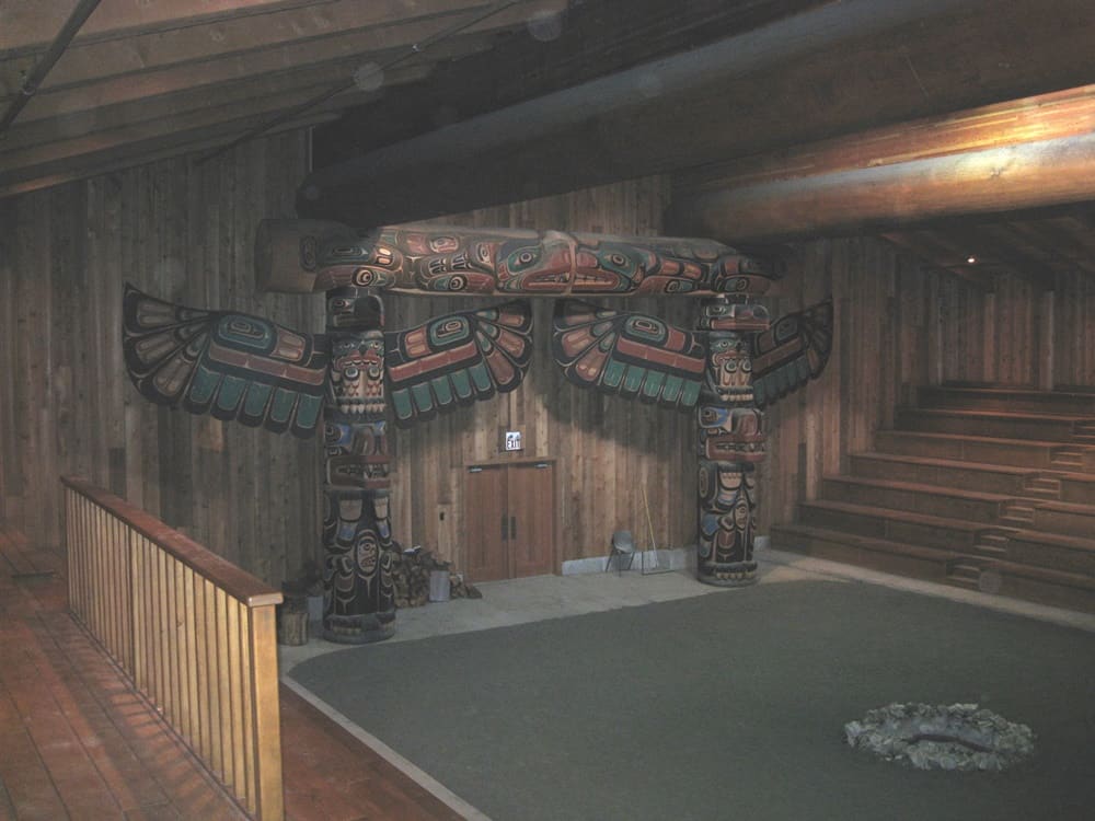 The First Nations people of Canada call the Kermode bear a spirit bear, as they believe them to have special powers. Here’s an interesting story about this from our overnight stop at Klemptu. It’s a tiny First Nations settlement, and at the time it contained a fish processing plant that was essentially the only employer in town. We wanted to visit a newly-built longhouse, and when we enquired at the café attached to the fish plant we were told, “Oh, Francis gives the tours . . . I’ll call him for you.”
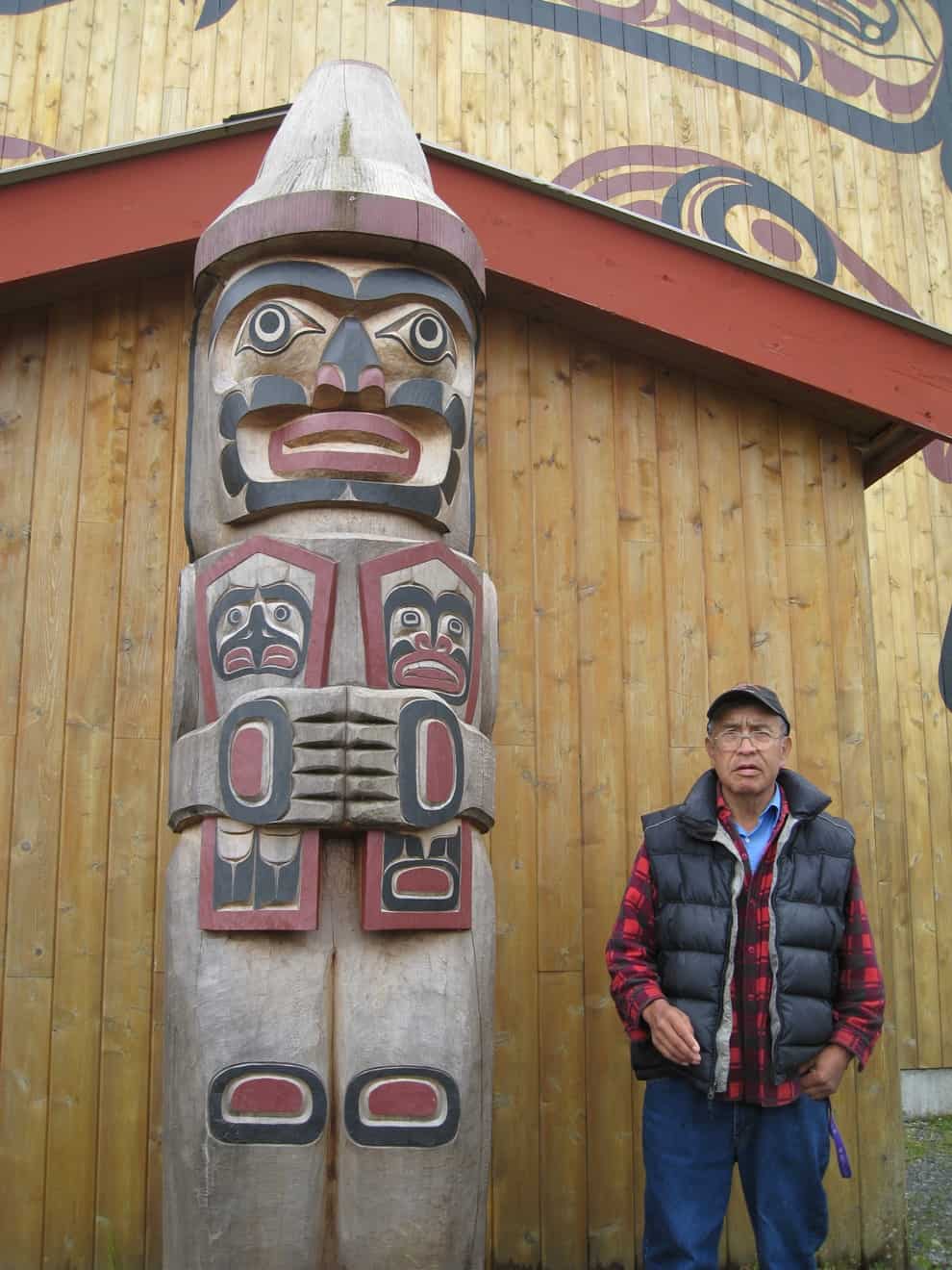
Francis, a First Nations elder showed up to give us a wonderful tour of the longhouse – and while he was very quiet, he was still quite a character (he’s pictured next to the totem outside the longhouse).
Originally, a longhouse in each First Nations settlement served as living quarters for several families. This one, though was newly built as a ceremonial house, with seating around the perimeter and an open area in the middle where tribal dances can be held. Behind the large wall in the photo was a hollowed-out cedar log, and it served as a musical drum (Kap played it, and the sound was amazing).
 But back to Francis. At one point in the tour, and in response to our query about the best place to see a spirit bear, Francis became very thoughtful, then told us to be on the watch all along the shoreline of Princess Royal Island to the north of Klemptu. He said they were very plentiful, and we would almost certainly see one (which surprised us, as we’d been led to believe you could transit this area dozens of times and never see one). What he said next left us more than a bit bemused. “Whenever I have a serious problem to resolve, I go to the beach and sit on a rock to think about the problem. When I’m deep in thought, a spirit bear will come beside me and sit down . . . and we think together. Very soon, the solution to the problem is clear to me, and I return to the village.” Hmmm, sounds like everyone needs a spirit bear hanging around for life’s difficulties.
And now for the scientific and number facts about the spirit bear. The Kermode is a subspecies of the American Black Bear (which is commonly called a grizzly bear), and is not an albino, nor is it related to polar bears or “blond” brown bears. Rather, their cream-colored fur is the result of a recessive gene. A darker patch of brown fur is typically on the neck or around the telltale grizzly bear hump of the back. For whatever reason, about 10% of the grizzly offspring in this area of the Pacific Northwest result in the crème-colored fur. Most interesting, research has shown that salmon catching efficiency of the spirit bear is some 30% higher than regular-colored grizzlies – most likely because it’s harder for the fish to see them in the light glare above the water’s surface.
According to people who track this sort of thing, there are only 400 Kermode bears in the coastal Canadian area, and approximately 120 of those are on Princess Royal Island. We certainly didn’t see any there. But amazingly, we spotted our little guy (or gal) almost 100 miles north of the usual habitat.
Two weeks later, one of the first things I did upon arrival in Juneau (the first large city north of Ketchikan), I searched out every large store that sold electronics and bought the absolute top-of-the-line digital camera I could find in town – a Nikon D60 SLR, with three interchangeable lens – one that I use almost all of the time is an 18-55mm wide angle zoom, the second a small, lightweight 55-200mm zoom, and the third a huge 70-300mm zoom. The camera itself is certainly heavier and larger than a point-and-shoot, but with my spirit bear experience, I’ve learned not to go anywhere without it now.
——————————————————————————————————————————————
 Continuing South. OK, enough digression – let’s get back to Summer, 2014 cruising. After a quick night at Lagoon Cove, Kap plotted the next day’s course to Blind Channel Resort. As always, the Blow Hole is the first bit of navigation challenge leaving Lagoon Cove, barely 300 yards after you pull away from the dock. You turn 90° to starboard, and you’re at the entrance to the Blow Hole, a narrow and shallow channel separating Minstrel Island and East Cracoft Island. We were at high tide, the seas were calm, the sky was bright blue, and you’d never guess that the photo at left could match the electronic chart and depth sounder shown below it.
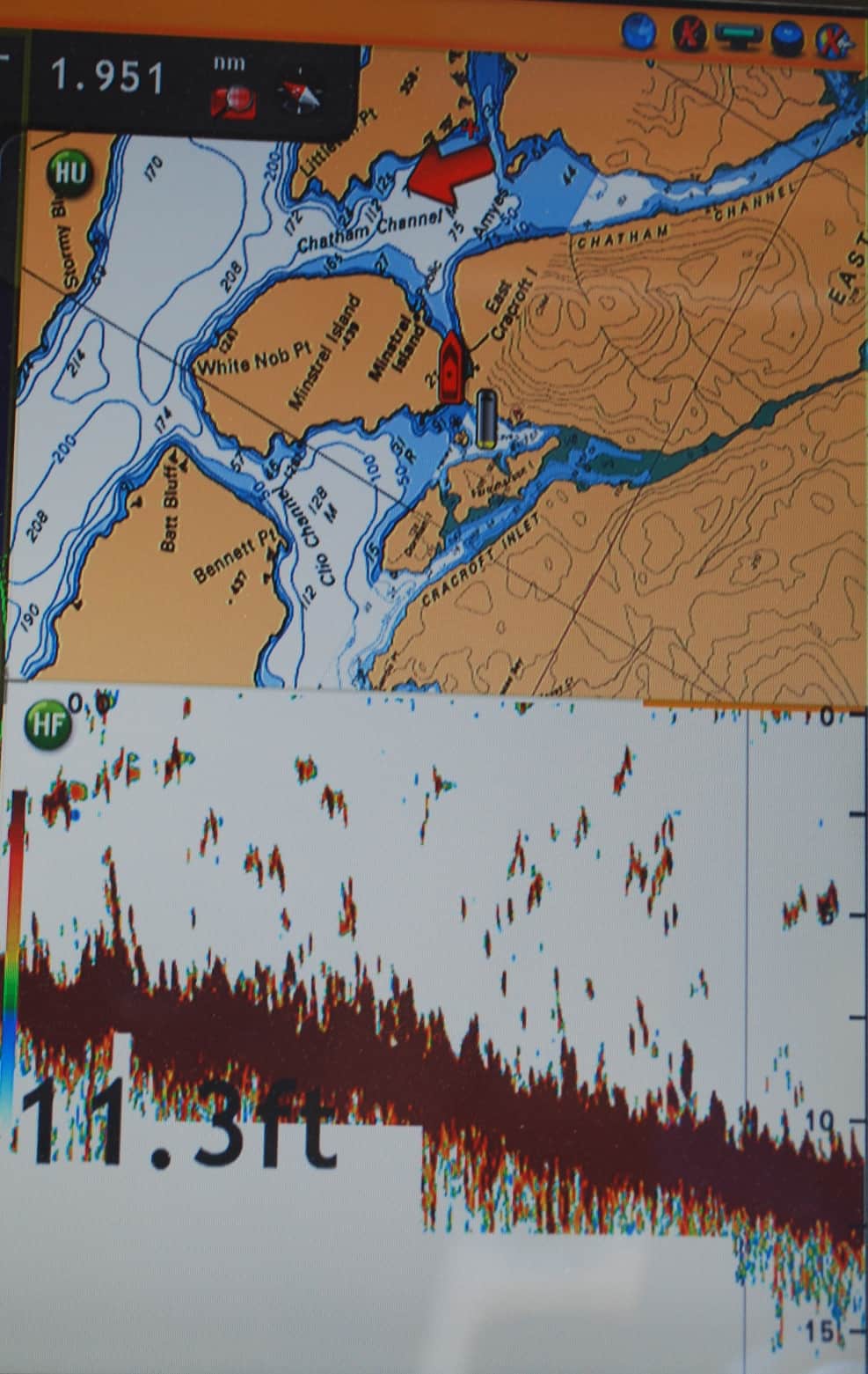 This shot was taken of a split screen image at our helm dashboard. The top screen is a Furuno chart plotter image that shows Flying Colours as the red boat-shaped image (the Blow Hole is so narrow that the boat image appears to be wider than the channel we’re going through). Below is a graphic image of what the depth sounder is “seeing” beneath the hull – the seismic-looking dark “stuff” is scatter caused by a mass of seaweed that fills the channel. The digits show the water depth, calibrated from the bottom of our hull to the water’s bottom (Flying Colours’ draft – the amount the hull sits below the waterline – is 5’, so that means the water here is just a bit over 16’ deep).
 The passage through the Blow Hole is only ¾ miles long, and at the end of it we again turned 90° to starboard into Chatham Channel. The run southward on Chatham Channel is 3-4 miles long, and the waterway then turns 90° to port and into a narrow, shallow section of the channel that shoals on both sides, requiring careful steering to ensure deep enough water. Range markers are set up at both ends of the channel to assist in guiding boats through it. The drill is, Kap and I both move to the fly bridge helm station to steer. While one of us steers, the other stands close-by and sights with binoculars on either the forward or rearward range finder (whichever is more visible). It’s hard to see in the photo, but the range finder is made up of two markers, one down near the waterline, and the other just above it – if the two are perfectly lined up, you are where you should be in the channel, and if the upper marker is to the left or right of the lower marker, it indicates whether you need to correct course to port or starboard to get back onto the centerline of the channel.
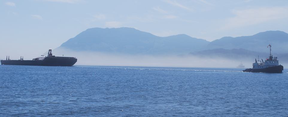 Soon we had Johnstone Strait in view, and it wasn’t comforting to see a low band of fog sitting at the waterline. We were even less comfortable when the shadowy image of a tug and barge became visible for a few moments through some island gaps just before we turned onto Johnstone Strait. Surprisingly, the fog was quickly lifting as we turned left onto Johnstone Strait, but even though we could see the AIS symbol for the tug and tow on our navigation plotter, we still couldn’t see anything of it in the fog ahead. The situation was getting pretty tense, as we could now see two AIS symbols, both dead ahead of us and closing on us quite rapidly. Kap and I disagreed on which way to turn – I wanted to turn to starboard to pass them, but she wanted to turn to port. But as she’s the Captain, one of our “rules of the road” is that her opinion overrides during a safety situation – and I have to admit, she was right. We turned to port to pass the tug starboard-to-starboard, and within a few seconds the tug and barge emerged from the fog (and I snapped the photo). As you can see, just behind the stern of the tug there’s another faint image still in the fog (you’ll probably have to click on it to enlarge for it to be visible) – it wasn’t until we were past that we could see it was another tug, and this one was towing a wide log boom. If we’d taken my opinion to pass port-to-port, it’s hard to say what our clearance would have been when we met the logs.
 Once past the excitement of the tug and tows, the ride down Johnstone Strait was uneventful. Just like it had been a month earlier when we came north, the sky was blue and almost cloudless, little wind, and the only thing to disturb the water was slight ripples.
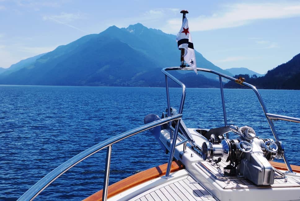
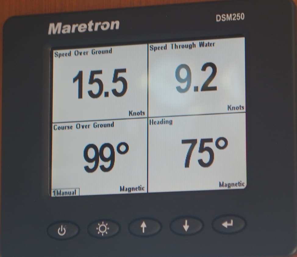 The best part, though, was going through Race Passage. With the narrowing of the waterway past Helmken Island, the ripples changed to whirlpools, and Flying Colours was turned from side to side – as much as 45° from our course centerline – by the incredibly powerful forces of the whirlpools. The photo at left illustrates what happens to the current when the channel narrows at a passage like this. At top right on the Maretron gauge, our “Speed Through Water” is shown at 9.2 knots, while our “Speed Over Ground” is 15.5 knots (remember, a knot is equal to 1.17 MPH, so this is about 10.75 MPH and 18.1 MPH, respectively). What that means is, we’re traveling “with” the current and it’s helping our true speed – in other words, the difference between 15.5 and 9.2 is the speed of the water we’re moving through, or 6.3 kts, moving in our direction with us. The beauty of that is, we’re only paying for diesel to push us at a speed of 9.2 kts, yet we’re actually moving over the ground at 15.5 kts. It’s a free 6.3 kts, which is around 7 miles per hour advantage that we get from the current.
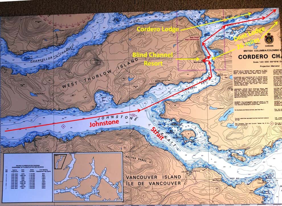
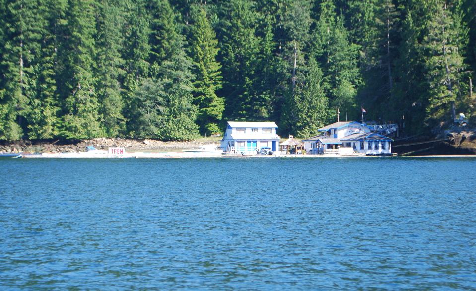 The overnight at Blind Channel was uneventful – and the only thing to write home about was the evening’s dinner of schnitzel and a good bottle of wine. In years past, our tradition has been to spend two nights at Blind Channel, the second night to dinghy over to Cordero Lodge for a second schnitzel dinner at their wonderful German restaurant – but alas, on the way north this year we learned the lodge has been sold, reportedly to a retired logging couple who are drunks – and they’ve just about destroyed the lodge. We gave it a pass on the way north, and now again on the way south. The accompanying photo shows the lodge and restaurant – but sadly, the docks to the left are completely empty. Our guess is, the place will be closed by next season, and there goes another of our great little places to stop on our journey north and south.
Dent Island Lodge. We had plenty of time to make the 300 mile cruise from Port McNeill to Sidney for the yard work, so we were taking it easy. After Blind Channel, we decided to stop for a night at Dent Island Lodge, the former vacation retreat for Seattle’s Nordstrom family, who decided a few years ago they just weren’t getting enough family use of it to justify it and turned it into an upscale fishing lodge. The best part of staying overnight is the fixed price dinner in the lodge dining room – very expensive, but it’s always been worth it.
 Since our morning cruise from Blind Channel was barely two hours, we arrived at lunch time, and after tying Flying Colours up at the dock, we headed for the deck just off the dining room for a quiet and relaxing lunch. Our table overlooked the rushing rapids that flow between Little Dent Island, and main Dent Island that the resort sits on. It also gave us a view to the dock area, where there were more “big” boats than we’ve ever seen there before – and it was a disquieting site to see all of the truly huge boats that stop off there. Dent is one of the few resorts/marinas this far north that has true 100A power, and a good percentage of the boats shown in the photo require 100A to power all of the large systems aboard the boats (we require 50A power). Frankly, it made me want to get out of there and never return.
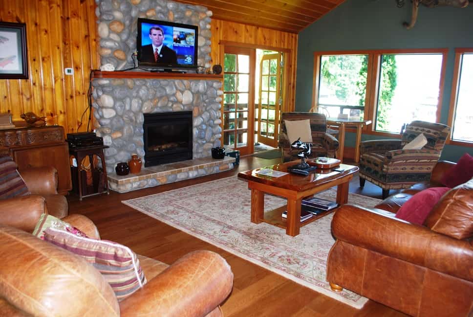 The lodge itself is quite a place – with a comfortable bar to hang out after a hard day of salmon fishing. Next door is a TV/library room, with comfortable leather couches and chairs to lounge in. Before dinner, they always set up an appetizer spread, this time with seared ahi tuna and lots of crudités. It opens into the dining room
This time, though, we learned on arrival that the fixed price dinner was instead going to be a buffet – with a choice of just BBQ ribs or prime rib. Neither of us are fans of buffet eating – our experience is, it’s typically the quantity, not the quality, that attracts people to buffet-style dining – and this one certainly wasn’t all that great . . . definitely not worth the price we paid.
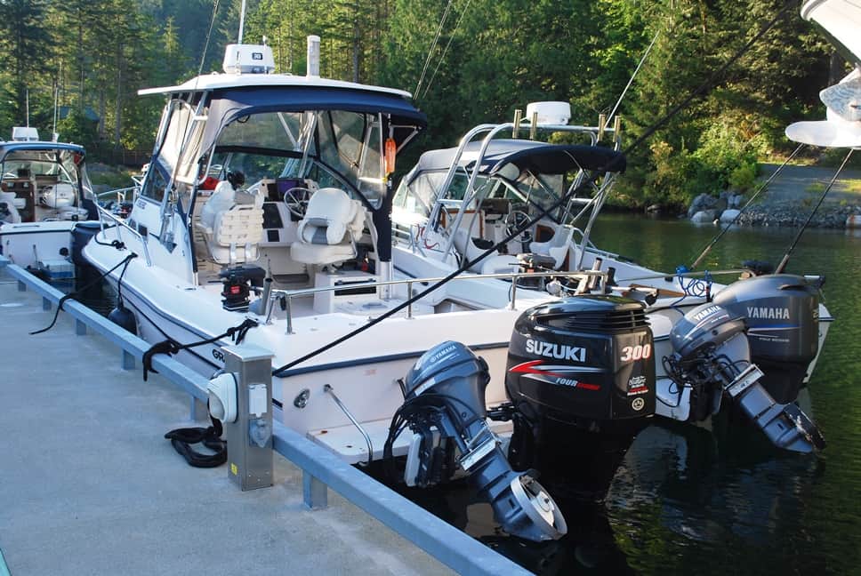 The reason for the buffet was, the lodge was holding a salmon fishing derby on Saturday, so there was a larger than usual crowd of fishermen. Other than seeing the usual Dent Lodge-owned “6-pack” charter boats for fishing (photo at left), we didn’t see much evidence of the derby, but when I took Gator for his afternoon walk I was surprised at all the activity at the head of the dock. All of the fishermen were in with their catch, they were being weighed to determine the derby’s winner, and there were 3-4 guides and fishermen at the fish cleaning station gutting, cleaning, and bagging dozens of salmon.
At dinner we inquired about the derby. Cost to enter was $800 per boat (no limit on the number of fishermen in a boat), and the winner took home $6,000 (winner was determined by the two largest fish from each boat). We were told the winners were a father/son pair who had hooked a 32 lb and 27 lb salmon almost at the same minute, and when they got back to the dock they learned they had the largest pair of salmon.
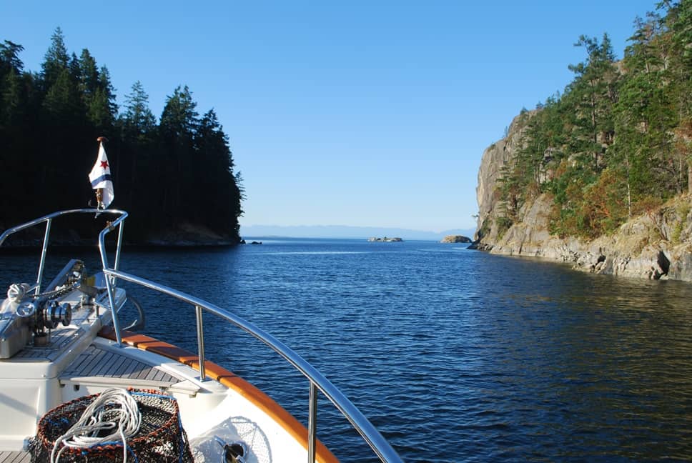 Gorge Harbour. Next day, we started with passage through Gillard and Yaculta Rapids timed for slack, then an easy 4-hour cruise down Calm Channel and around the corner to Gorge Harbour. Again, moorage at a dock that supplied shore power to us was a big factor, as without the house bank batteries, we’d have to run the generator all night long if we tried anchoring. The second reason for choosing Gorge Harbour was . . . well, OK, it was dinner. There’s a wonderful restaurant just up the shore from the marina – called the Floathouse Restaurant, as it’s actually an old float house from decades ago that was hauled up on shore, cleaned up, and turned into a great restaurant. With lots of time to get to Sidney, we decided this quiet and secluded harbor was a good place to spend two nights. The photo at left shows Flying Colours in the narrow passage – the gorge – that leads into and out of the harbor – in this shot we are exiting the harbor.
——————————————————————————————————————————————
It’s “Déjà Vu All Over Again” says Gator. OK, since I’m in digression mode on this blog post, here’s another from a few years earlier – and one that begins at Gorge Harbour.
It was 2007, aboard our first-ever boat, Cosmo Place, a 42’ Nordic Tug. We had ZuZu, Gator, and Raz with us, and we’d been out for most of the summer exploring the Broughton’s and were slowly heading south as the summer ended.
I’m sure Gator remembers this part well – anchored in Gorge Harbour, about 400’ off the marina dock in 35’ of water. A couple hours after we arrived, our friends, Jim and Paula aboard their 45’ sailboat, Apt. 5, arrived and rafted up to us for the night. The next morning I made a latte for Paula and Jim, and as they sipped it, Gator and I were standing in the cockpit of Cosmo Place talking across to them. Gator was leaning against my leg, quiet as he always is, when all of a sudden he let out a blood-curdling scream of pain. He just stood there, screaming and screaming, as only a Basenji can do. He was obviously in the worst pain of his life, but there was no indication where it came from. First thing we thought of was possibly a wasp sting, but nothing was swelling up. It could be a tooth, it could be an internal injury . . . it could be anything! Nothing we tried to do seemed to help; no change of position seemed to help; the pain just wouldn’t go away.
Very quickly, Kap and I decided we needed to get him to a vet, and the nearest one was in Campbell River, about 15-20 miles away on Vancouver Island. Leaving Paula and Jim in a very surprised state (given that they’d just cruised over 100 miles north to meet up with us), we pulled up our anchor, cast off their rafting lines, and we quickly motored out of Gorge Harbour. Once in open water, we opened the Nordic up to full speed (16 knots), and made for Discovery Harbour Marina in Campbell River. As we sped across, I called the marina, told them of our situation and got a moorage spot for the night. I also asked for contact information on the nearest vet. I then called the vet, learned they were closing for the day within the next hour, and after explaining Gator’s symptoms they said they’d stay open until we arrived.
Since the vet was about a mile from the marina, going by foot with Gator was out of the question, so I called the Bee Line Taxi and asked them to meet us at the head of the dock. Gingerly carrying Gator – he was still in excruciating pain, letting out a howl every now and again and in between just whimpering – we managed to get him into the taxi. The woman driver was a dog lover and she understood the problem, and waived her normal prohibition of pets in the taxi.
At the vet office, Gator was taken into an exam room and we were told they’d do an X-ray if they could. With the pain he was in, it was impossible to keep him quiet and still, and from the only X-ray they could get, nothing showed up. They said they’d like to sedate him, keep him overnight, and at some point they’d try again to get an X-ray.
In the morning we returned and had a long chat with the vet. Sedated with morphine, he was able to keep Gator still enough to get an X-ray of his spine, and the only possible thing he could see was the faintest hairline crack in a cervical (neck) vertebrae. Since soft tissue obviously doesn’t show in an X-ray, there was no way to tell if there was any problem with a cervical disc, but he suspected a herniated disc. Other than give us a prescription for a pain medication, there was nothing he could do about it, and we discussed at length the idea of getting Gator back to the Seattle area for whatever treatment we could find.
Using the same taxi service, we got Gator back to Cosmo Place, and then went back to town to fill the pain prescription. Kap and I talked it over and we decided to head south as fast as possible to Nanaimo, where we could pick up a Kenmore Air flight to Seattle (knowing what we know now, we should have gone straight back to Gorge Harbour, as Kenmore Air flies into there every day, and we could have had him home that afternoon). In our plan, once at Nanaimo Kap would stay on Cosmo Place with Raz and ZuZu, while I flew home with Gator.
Our late departure from Campbell River necessitated an overnight stop in Comox (more about it in a bit), then down to Nanaimo the following day. Along the way, I made flight reservations for me and Gator on a Kenmore Air floatplane from Nanaimo to Seattle. It certainly wasn’t a comfortable flight for Gator, but we had him on enough pain medication that he was pretty well zonked out. As soon as I arrived in Seattle, we met up with Lisa Hart – Gator’s co-owner with us – and we took him straight to a specialty vet hospital in Lynnwood. There, they have MRI and CT Scan equipment, specialty doctors and surgeons – even an orthopedic surgeon, which is who saw Gator. He was given an MRI (and a spinal tap to ensure it wasn’t actually meningitis), and when it was determined to definitely be a herniated disk, surgery was not recommended but the surgeon recommended 6-weeks of bed rest.
Can you imagine that . . . bed rest for a Basenji! The dilemma was, what to do with Gator, plus how to resolve the situation that Kap was still in Nanaimo on Cosmo Place. I placed him in a suite at a “pet resort” near Sea-Tac that we frequently use, where they could keep him totally quiet in his comfy little room (complete with a low, near-to-the-ground trundle bed, Disney movies playing on a wall-mounted TV), and I flew back to Nanaimo where our summer cruising continued.
——————————————————————————————————————————————
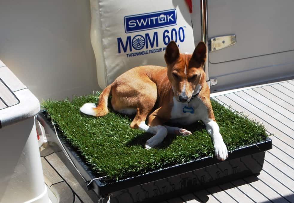 Back again to today’s story – and one more little “situation” with Gator. In the accompanying photo, he’s seemingly saying, “Uhhhhh . . . what is it that I’m supposed to do with this “pup head”? (Honest . . . this is the name they sell these things under.) Due to the difficulty of taking dogs ashore when we’re at anchor, we’ve tried just about everything to get them used to the idea of “doing their business” aboard the boat – all to no avail. Every boater who has a dog on board has ideas for how to make it work, but what we’ve learned from years of talking about this and trying things – if they don’t learn it young, they never do – and Gator didn’t see his first boat until he was about seven years old. So, his idea of a grass patch is . . . yup, something to sleep on. Maybe when we finally get young Jamie with us on the boat (Gator’s daughter, who is just 1½ years old), we’re hoping she can learn at her tender age . . . and then teach Gator how it’s done at the same time.
Gorge Harbour to Comox. Nearing the end of our journey to Sidney, we next had a 31-mile cruise down the Strait of Georgia to Comox. Our only visit to Comox was in 2007 when we were on the emergency trip to get Gator to an orthopedic vet in Seattle, so our time there was a bit of a blur. Again, Kap picked a good day to leave (she worries the weather data a lot, making sure we don’t lollygag around someplace and then find ourselves up against the wall on a high wind or high seas day). We departed Gorge Harbour under blue skies, light winds on our stern, and a slight current going with us – what could be better?
The tricky bit was crossing the Comox Bar – it’s a higher-than-normal pucker factor in getting into Comox. This is only our second time to cross it, and the first time was seven years ago, so only the most significant details stuck in our memory. Luckily, we had at least five cruising guide sources for advice.
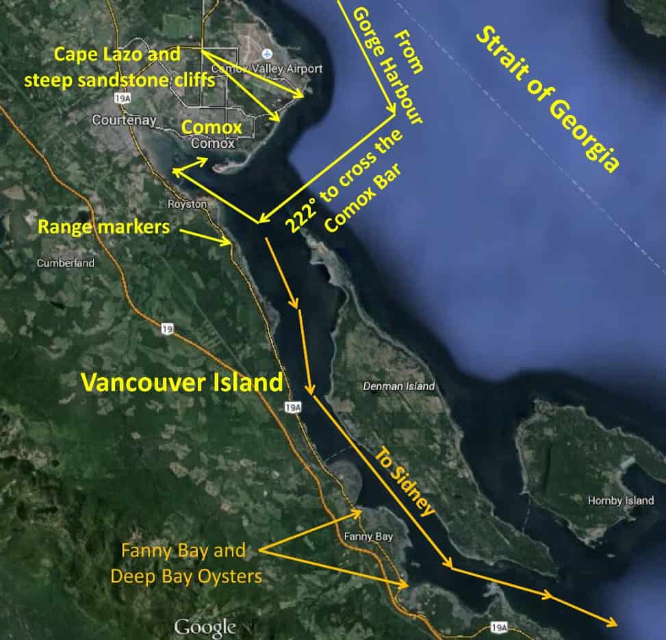 Unlike other harbor entrances with a sand bar at the mouth, the unusual part of this one is, you have to cross it south of Comox, entering exactly on a course heading of 222° (which is just about 90° to the shoreline). The town and Comox Harbour is completely hidden behind a white sandstone bluff. The point you enter is only identified by a pair of range markers at least two miles away on the shore – so therefore, at that distance the actual range markers are invisible, but each has a very bright yellow light that is clearly visible at night or in light fog, but almost impossible to see in bright daylight (which was our situation). Worse, the upper range marker is obscured by trees until you are almost perfectly lined up, so you have to be very watchful not to cruise south past the entrance. Luckily, from outside the bar you can see two red channel marker buoys off the shore that mark the turn back to the north, past a spit, and into the otherwise hidden Comox Harbour. We also had the advantage of following another Seattle Yacht Club boat across the bar – but that can be problematic too, as there’s no guarantee the other boat driver really knows what he/she is doing (it’s verystupid to run aground because you’re following someone else, duh!).
With Kap at the helm, I kept a close eye on the range markers and buoys with binoculars and we safely crossed the bar. A good side-tie slip was awaiting us at the Comox Valley Harbour Authority Marina – a working marina with quite a few commercial fishing boats around us, one of them selling fresh-caught fish and shellfish from the back of his boat. We were tied up in almost exactly the same position on the dock as the night we were bringing Gator south for his neck vertebrae problem, but there was no indication of his “Déjà Vu all over again” perspective.
There were three reasons for choosing Comox on this stop: (1) it was conveniently located to give us a long one-day cruise to Ganges on departure; (2) it’s reportedly a nice town of 12,000 population, sort of a Sidney-by-the-sea type of town, and we wanted to sample it; and (3) a friend who cruises this area a lot told us there is an excellent Italian restaurant just a couple of blocks from the marina, and we currently don’t have any Italian restaurants in our list of favorites in these cruising grounds.
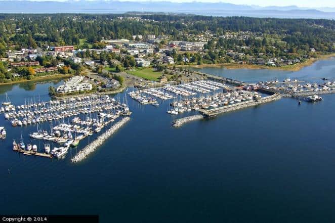 In the accompanying aerial photo (that I took from Google Images and couldn’t find the name of the copyright owner to credit), there are three marinas in Comox, and we moored at the municipal marina, at the far right of the photo. From there, it’s a short two block walk to the Comox city center, and just one block to Toscano’s Trattoria.
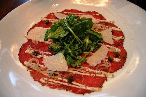 Unfortuantely, there wasn’t as much to see and do in Comox as we’d have liked, so we settled on a single overnight stay. The restaurant, though, was open for dinner, and true to the recommendation, it was great. I had one of my most favorite Italian starters – the first thing I always look for on an Italian restaurant menu, Beef Carpaccio – wafer-thin rounds of raw beef tenderloin, with aioli drizzled over it, lots of capers scattered around, shaved Parmesan cheese, and a mound of arugula to top it off. There’s was great, and just the way I like it! For a main, Kap had medallions of beef tenderloin with sautéed wild mushrooms in a red wine demi-glace, and I had Fettuccine Alfredo. All of it lived up to the recommendation, and just might be a reason to return to Comox.
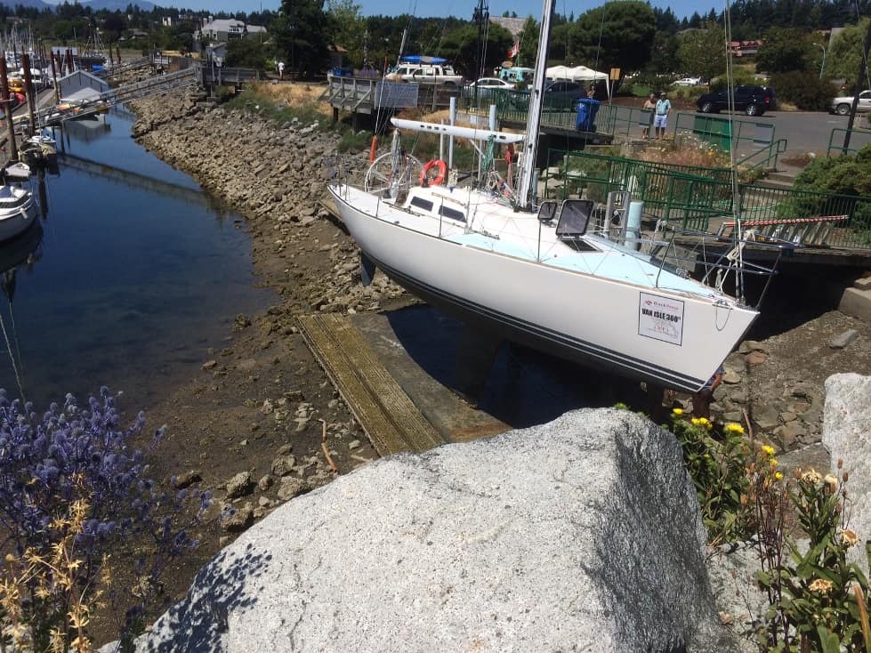 One item of interest that we don’t often see south of SE Alaska is a tidal grid – and to our surprise there was one at the head of our marina dock. Actually, there could be a tidal grid right next to any dock and you might not even notice it unless there’s a boat using it – and in this case there was, the 30’ sailboat shown in the accompanying photo.
The way it works is, at high tide a boat owner steers the boat onto the grid – in this case just a concrete pad below the water surface, with a framework on the shore side that you then securely tie the boat to. As the tide drops, the boat lowers with the tide until the keel is resting on the grid below. Once the area to be worked on is exposed, you have until the next high tide to get your work done – at which point, if you have the work finished you can unhook and drive away, or if you need more time, wait until the next low tide to do more work. It’s a very cost efficient way to get bottom work done without having to pay for a haul-out, which can easily run into a few hundred bucks.
Here in Comox, the range from high to low tide is typically 12-14’ (in SE Alaska, it’s as much as 25’), and what part of the boat you’re working on will determine how much time you have. If you’re working near the waterline, you have the most time; at the bottom of the keel is the least time. Most importantly, if you’re doing something that opens a hole below the waterline, you have to make sure it’s sealed back up before the rising water line gets to it.
 Here’s my last digression for this blog post, also from the SE Alaska cruise in 2008 – and goes with the photo at left. Late in the afternoon one day, Kap and I pulled into a secluded little bay called Meyer’s Chuck, a bit north of Ketchikan. Shortly after we tied up at the free government dock, a small runabout came into the bay at a fast clip. It was near high tide – and ebbing towards low tide at the time. Seeming to know exactly where he was going, he pulled alongside the tidal grid at the shore just inside the float where we were moored. He quickly secured to the vertical pilings of the grid, and while he waited a few minutes for the lowering tide to expose the underside of his boat, he ran up to the nearby house on the shore, presumably to borrow an electric sander and some extension cords. Once set up, he immediately went to work, grinding out and sealing a hole punched in the hull by a log he’d hit in open waters outside the bay. Luck was with him – it was high tide and he was able to get onto the tidal grid for the repair. We later learned he’s a local resident of Meyers Chuck, and from his casual handling of the situation, has probably used the tidal grid many times.
Comox to Ganges (on Salt Spring Island). It was an early morning departure the next morning – at 6AM – as the 11AM slack at Dodd Narrows was our determining factor on the cruise south, and Kap figured it would take us 5 hours to get there (with her usual fudge factor built in). Our route was southward on the west side of the Strait of Georgia, then through Dodd Narrows just south of Nanaimo, along Trincomali Channel, and down Salt Spring Island until a sharp 180° turn took us into Ganges Bay. The run is 80 miles, so it was planned to be upwards of an 8-hour day on the water. We’d have the wind and current with us all morning, so that would really help out on the ground speed.
Again, Kap worked her magic with the weather and came up with a really good day for cruising, at least in the morning. Strong winds and 4’ seas were forecast for early afternoon as we approached the Nanaimo area, so we didn’t waste any time throughout the morning. As we approached Nanaimo, we were surprised that the stong winds and 4′ seas weren’t materializing – but just after passing Winchelsea Island (that monitors the Whiskey Golf naval weapons area), both hit with a vengeance. We rocked and rolled all the way to Dodd Narrows, and were definitely glad to get in the shadow of it after passing through.
But I’m getting ahead. On departure from Comox, we didn’t have to cross the Comox Bar so that helped too. If you elect to cruise directly south from Comox, hugging the coastline, you can stay inside the bar (see the annotated Google Map above to see our route), traveling in the channel between Vancouver Island and Denman Island, then past the bottom of Hornby Island, and continuing on the Strait of Georgia. It also cuts off a couple of miles, so that helps, and while it doesn’t look it on the map, it’s plenty wide and nothing to restrict our speed.
 Fanny Bay and Deep Bay oysters. If you’re an oyster lover (so this one’s for you, Elliot Parks), a plate of plump oysters from British Columbia might make your mouth water (I’m definitely not an oyster lover, so I have no idea if this suggestion is valid). I bring this up because we cruised by Fanny Bay and Deep Bay on our way south from Comox to Ganges. Fanny Bay oysters are one of the most common type found on most oyster samplers at Seattle seafood restaurants, and they ship to restaurants across North America and globally. On one restaurant menu I looked up (The Fish Market in Southern California), they write about Fanny Bay oysters, “A Pacific oyster variety from British Columbia, firm texture, mildly briny, plump, sweet finish”, and about Deep Bay oysters, “A variety of European oyster, firm texture, complex flavor, mineral finish, from British Columbia”. The Oyster Guide says about Fanny Bay oysters, “they’re considered the archetypal B.C. oyster – smooth, but with a pronounced cucumber finish”.
The oysters from the Fanny Bay area are a variety called Pacific Oysters. Also called a Japanese oyster or Miyago oyster, they are native to the Pacific coast of Asia, and have now been introduced to North America, Australia, Europe, and New Zealand. They were first introduced to the Fanny Bay area in 1912 or 1913, with further seedings around 1925. Due to a lack of Pacific oysters from Japan during World War II, additional seedings were done in the area in 1942. The first major aquaculture (farmed production) of Pacific oyster was done by a gentleman named Joseph McLellan, who seeded the beach areas around Fanny Bay, Mud Bay, Ship Point, Buckley Bay and Denman Island. There are now over a hundred people employed on oyster production at Mac’s Oysters Ltd, and McLellan’s descendants still own and operate the oyster and clam farm. It’s a fourth-generation family shellfish farm, and is the only shellfish processor in Fanny Bay, and they process around a third of all of B.C. oysters from this area.
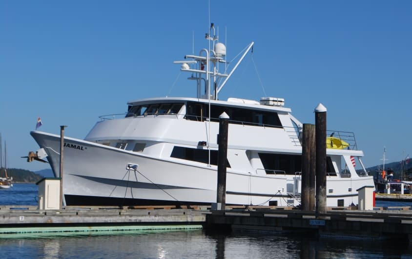 Jamal at Ganges Marina. A boat with an interesting history was across the dock from us when we arrived at Ganges Marina – the 72’ Hatteras named Jamal (funny name for a boat, and we don’t know the origin of it). It’s a charter cruise boat from Bellingham, taking something on the order of 8-10 passengers around the San Juan and Gulf Islands.
In 2011, the Jamal was approaching Bedwell Harbour to clear Canadian Customs, on South Pender Island in the Gulf Islands and just inside Canadian waters. We heard various reports, but the one we think is true is that a major mechanical problem occurred just then (or had occurred earlier and no one noticed) – and apparently no one was at the helm as it approached the Customs dock (the Captain was supposedly away from the helm station and in the engine room trying to resolve the problem – maybe the steering linkage failed, maybe gearbox problems . . . who knows?). Traveling perpendicular to the dock, at way more than docking speed, and to the horror of several people standing on the dock, the Jamal sliced through one of the Customs’ floating docks and clipped the bow of a 38’ sailboat named Misty, also tied there to clear Customs. The owners of the sailboat live in Florida, but keep their boat at Cap Sante Marina in Anacortes (the next marina from where we keep Flying Colours). They were just departing on a long-planned cruise to SE Alaska – and this incident certainly cut it short. (Before we got our Nexus cards (that allow Customs clearance by phone) Kap and I had cleared once at Bedwell. The normal drill is to moor at the floating Custom’s dock and walk up to the head of the dock where there are several direct telephone lines mounted on an outside wall. When you pick up a handset a Customs official answers to clear you. If they want to board your boat for any reason, you return to the boat and wait for them to come to you, or if no one from Customs is available, they might direct you to head immediately to Sidney and wait at the Customs dock there.)
After the bedlam at Bedwell from the Jamal incident, all of officialdom arrived – Customs officers, RCMP officers, and some Coast Guard officers. Not long after, an insurance adjuster arrived by float plane from Vancouver – and after surveying the damage (and not knowing anything about boats), he suggested they “get three estimates” of the damage – which is nigh well impossible.
By now, the Jamal had departed, so basically telling the insurance adjuster to stuff it, the sailboat owners immediately telephoned the Jamal’s owner. He clearly understood the situation, and like a really good owner should, told them to take the sailboat directly to Philbrook’s Boatyard in Sidney – and he’d handle everything with the insurance company. Sidney is only a few miles west of Bedwell Harbour, and by the time they arrived a yard crew was already scheduled to start repairs – which took 2½ weeks. What a way to start a long-awaited summer holiday cruising vacation!
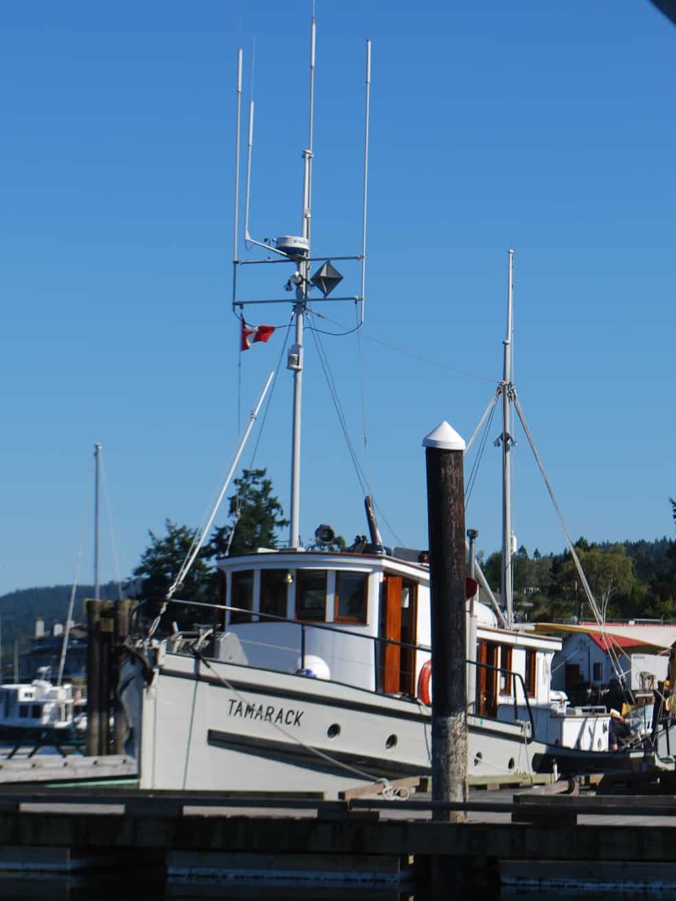 Soap box – What Should A Boat Look Like? Scroll back up to the previous photo and fix the looks of that boat in your mind. Then look at the Tamarack pictured here, and ask yourself . . . “which one looks more like a boat should?” If you said the Tamarack, then your eye for boat design matches mine.
The only reason I ask this is, the Tamarack was also moored right next to us at Ganges Marina, and the lines of this classic old tug/cruiser brought a smile to my face every time I looked at it. While it looks more like a work boat than the glitzy fiberglass boats you see so much of these days, it has the comfortable style of what a good, seaworthy boat should look like. It’s probably over 60 years old, with leaks that crop up all too often, old mechanical systems that break down too often, and with far too much maintenance required for the casual boater. Nevertheless, it’s obviously the pride and joy of the guy we saw fussing over her.
Final Leg . . . Ganges To Sidney. It’s a short 15 mile cruise southward from Ganges to Sidney, so the only question on departure time on Thursday morning (July 17th) was weather. We’d spend our last long weekend before the maintenance work in Couverden’s slip at Port Sidney Marina, so there was no problem showing up early (typically in a marina slip it’s like hotel check-out – if you arrive before last night’s guest departs, your slip isn’t available). At the end of the weekend we’d move over to the Delta Marine yard for the maintenance work to begin.
 The only hazards to our navigation were B.C. Ferries zipping around us as we neared Sidney. (These guys cruise at over 22 kts (almost 26 MPH), which is over twice our speed, so when they’re bearing down on us, the closing speed is a bit breathtaking – particularly given their size!) The ferry dock for all B.C. ferries coming into Victoria is actually in Sidney (20 miles to the north), at the north end of town and next door to Tsehum Harbour where the work was to be done on Flying Colours. There are behemoth ferries (like the two crossing behind us in the accompanying photo) arriving and departing every hour from Vancouver’s Tsawwassen ferry terminal, plus several smaller hourly ferries that service Canada’s Gulf Islands.
The big excitement of the weekend was my trip across to Anacortes on Friday to pick up our van (the big white whale that we used for many years towing our glider) and bring it back to Sidney. With Flying Colours moored at Delta Marine, there’s no way to get back and forth to town for supplies or anything we’d need for the last few days on the boat. Plus, when we cross back to the U.S. on a Washington State Ferry to spend the time at home while the work goes on, Gator would otherwise have to ride in his crate, locked in a drafty, cold, scary wagon cart on the car/truck deck of the ferry, and having done that once with him when he traveled across the English Channel on a ferry, we don’t do that anymore. Instead, he’ll get the comfort of riding in the van.
Anyway, the excitement of the van/ferry trip was that I’d travel across from Sidney to Anacortes as a foot passenger on the 12 noon sailing, arriving at Anacortes at 2:10PM. The only return ferry was an almost immediate turnaround from my arrival, departing at 2:50PM – giving me a scant 40 minutes to take a taxi from the ferry terminal into town, get to the Anacortes Marina where our van was parked (hopefully it would start after two months sitting), and get back to the ferry. If it didn’t work out, I’d be spending Saturday night in a hotel/motel in Anacortes. To help with my timing, I’d booked an Anacortes Taxi to pick me up at the ferry dock.
Things didn’t start off well. We were about 10 minutes late leaving Sidney. Almost immediately after leaving the ferry dock, the ferry slowed to a crawl and the Captain announced on the PA system that we’d encountered a pod of Orcas (Killer Whales), and by law he’s obligated to slow to avoid hitting any of them (plus it gives the passengers a whale watching experience for the cost of a ferry ticket) – and that cost us another ten minutes. On the Anacortes side, even though everyone on board clears U.S. Customs and Immigration at the Sidney ferry terminal before boarding, there’s still another Custom’s check of passports (with a couple of fishing expedition questions) on the Anacortes side. By the time I walked out of the Anacortes ferry terminal it was already 2:17, which was bad enough, but as we drove up the hill in the taxi to the main road to Anacortes, the ticket window line of cars waiting for ferries was backed up at least a mile – dang! – I’d completely forgotten about Friday afternoon ferry lines for people heading out on weekend trips! I texted a message to Kap that things didn’t look good, and I’d probably be spending the night in Anacortes.
When I got to the van it started in an instant, I got the window sun shades pulled down, and I headed back at maximum legal speed to the ferry terminal – knowing it was hopeless. When I arrived, the backup line was about half as long as it was 20 minutes earlier, and I could actually see the ticket booth ahead. The line was moving much faster than I expected, but it was 2:51 when I pulled up to the ticket window.
“Any chance at all of getting on the 2:50 to Sidney”, I queried the ticket taker?
He shook his head, “I think they just pulled up the ramp . . . but I’ll give them a call.” He did, got news that the ramp hadn’t been pulled up, and he quickly told them he had one more. He took my money and said, “Get in Lane 1 and head straight down to the ferry . . . they’ll wait for you.”
I couldn’t believe it! I texted Kap that I was the last car to load on the ferry, and it was pulling away from the dock.
Sunday morning, we moved Flying Colours to Delta Marine, and to our surprise, the new house bank batteries had arrived and at 7:30AM Monday the shipyard workers began taking out our old batteries and loading in the new. It’s backbreaking work, as each of the eight batteries weighs 90 lbs, and they have to be manhandled onto the boat, then down a hatch into the engine room. Two young guys did the work, and it certainly wasn’t something I’d want to do. Tuesday, Kap, Gator, and I were ready for the noon ferry to Anacortes and we headed for a two week stay at home.
On or about the weekend of August 1st, we’ll return to Flying Colours, and the plan is to take her around the south end of Vancouver Island, and up the west coast to Barkley Sound. If all goes well, we’ll be there for a month, exploring this huge sound, maybe doing some prawning, and with a new rod and reel that Steve (from Couverden) picked up for Kap, she might try her hand at fishing for salmon.
Stay tuned.
Ron