
Tuesday, June 7th. Under gray skies and a cool-ish temperature of 57ºF, we departed Port Sidney Marina at 9:22AM bound for Nanaimo. Kap figured the tides and current to get us through Dodd Narrows at 2:28PM for slack water, so we needed to depart no later than 9:40 to get us there at our preferred cruising speed of 9 knots.
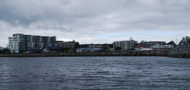
We departed Sidney with heavy gray skies threatening rain. Sidney is well known as a retirement community, with a very high geriatric population that rides around on motorized wheelchairs – so many, in fact, that they have “senior” parking rather than handicapped parking stalls, and more motorized wheelchair paths than bike paths. It was also the center of rum running to drop-off points on dark moonless nights to San Juan beaches during America’s Prohibition days.
If you’re reading this from the e-mail subscriber copy, I should point out that it isn’t all that easy to read. Photo captions show up as regular text, so reading it is somewhat disjointed, and the formatting isn’t as good. The e-mail is good for notification when a new post has been published, and if you have Internet access, you might want to logon to www.ronf-flyingcolours.com to read the actual blog post.
Also, click on any photo to enlarge it.
As planned, we’d spent a long 3-day weekend in Sidney, filling the fridge with enough provisions to last us until we head home for our first weeklong return trip on June 20th. Our best find was a German sausage deli that supplies meats to the Suisse Bistro in Sidney that we like so much – a place called Starkes Deli, located near the Victoria International Airport.
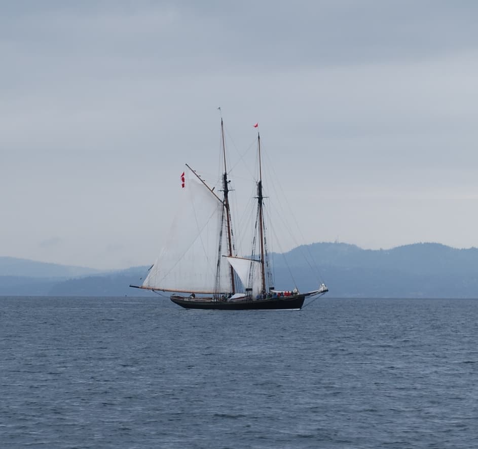
This gaff-rigged two-masted sailboat passed alongside us going south as we cruised northward from Sidney around Coal Island.
Steve and Shirley Clark returned Sunday night, and over cocktails we picked their brains on prawning techniques – in addition to giving us two meal’s worth of spotted prawns to tide us over until we can (hopefully) start pulling up our own.
Our route to Nanaimo takes us due north out of Sidney, then we turned west on Satellite Channel to head up the west side of Saltspring Island through Sansum Narrows.
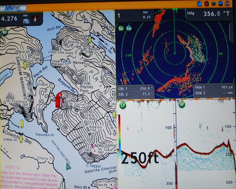
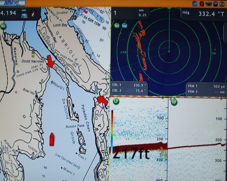
This 3-way split-screen shot of our Furuno Navnet 3D navigation screen shows us entering Sansum Narrows (we’re the red pointy-boat near the center), winding our way through the Narrow’s S-curve. On our starboard side is Saltspring Island, and on our port is Vancouver Island. The close contour lines on Saltspring Island attest to the steep mountains that dominate most of the island. Around to the west from Separation Point on our stern is Genoa Bay (unnamed on the chart at this zoom level), where there’s a nice quaint resort and plenty of protected anchorage. Ahead and to our port side is Maple Bay, with another small marina that we’ve stayed at a couple of times in the past. Ganges – where I picked up our wine over the weekend – is on the east side of the island and at the head of the long inlet to the NE of our nose.
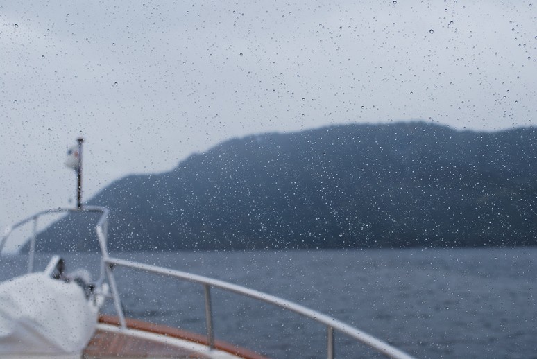
It’s surely raining outside as we pass through Sansum Narrows. The wind is also gusting to 20 knots and starting to whip up wind-waves. On our starboard and ahead is Mt Vesuvius, not looking at all like its namesake in Italy, but presumably reminding someone of it when it was named.
As we followed the channel up the west side of Saltspring Island, the winds rose more than forecast, with an apparent wind reading of up to 28 knots on our nose. With our speed over ground at 8 knots, the true wind was 20 knots. Rain was moderate but steady. Kap was concerned about possible winds after we left the Narrows and announced she wanted to stop at the Seattle Yacht Club outstation on Ovens Island if the winds persisted. Ahead, though, we could soon see lightening skies on our course.
As we continued into Stuart Channel, passing Chemainus on our port side and Telegraph Cove on our starboard, the sky turned blue, with light cloud cover, very calm seas, and it became a wonderful day for cruising. Kap had been at the wheel for about two hours, and after fixing us a couple of sandwiches to snack on, I took over the helm.
By 1PM we could spot Dodd Narrows in the distance, and with slack water at 2:28PM it was obvious we were ahead of schedule and would arrive while the current was still flooding south through the very narrow channel separating Mudge Island from Vancouver Island. I was at the helm and Kap was taking a much-needed snooze, and reduced our speed to a scant 5 knots – it’s more interesting to do that than arrive ahead of time and have to wait around.
Gabriola Island is quite a large island that lies off the east coast of Vancouver Island and in the Strait of Georgia. It would present a fairly narrow choke point by itself, but Mudge Island jammed into the south side of it makes it a serious narrows – called Dodd Narrows. While the Narrows is deep, the current sweeps through its dogleg bend at 9 knots – the speed we normally cruise at, and faster than most sailboats cruise under power. On our chart plotting screen, Flying Colours is the pointy red boat thing at the bottom of the screen. A red arrow is smack in the middle of Dodd Narrows, alerting us that the current is still running against us (and if you zoom in, it tells you the predicted current speed at the time). Boats waiting to transit Dodd Narrows from south to north gather around Round Island, normally queuing in the order of arrival, but there’s always some jackass go-fast boater whose life is “all about me”, and jumps the gun, roaring through at top speed and setting up a wake that all the rest of us then have to contend with. Behavior like that often brings a sarcastic comment on the radio about the boater’s parentage, but chances are, he (it's always a guy) doesn't have the radio on – and if they did, wouldn’t care.
Through binoculars, we could see at least five sailboats milling about, one with full sails up, tacking back and forth across Stuart Channel – at least he was having some fun while waiting for slack. Another sailboat came through Dodd Narrows to the south, and with the 2 knot current figured he could maintain sufficient rudder control.
In past years, we’ve gone through Dodd Narrows without problem as much as ½ hour before slack. We passed Round Island – about ½ mile before the entrance to Dodd Narrows at 2:00PM, and it was obvious the 5-6 boats ahead of us were going through. The conga line procession, and after passing a sailboat ahead of us who was traveling 1-2 knots slower than we were, we too entered the line. Kap asked if I was “up” to piloting us through the Narrows, and having done it two or three times before, I had no problem with that. Normally, I defer to her to be at the helm, as it keeps me free to snap away with photos.
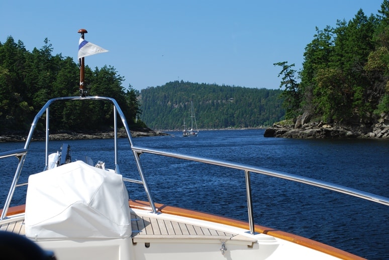
I snapped this photo as we entered Dodd Narrows, and just before Kap made our Securité call. Ahead, you can see two sailboats that we followed through. There were 3-4 boats behind us. From the looks of the sky and water, you’d think this was a glorious day. It was – at that moment – but almost immediately after we crossed through Dodd Narrows and into Northumberland Channel, the wind picked up and the sky turned angrier.
Normal protocol is to announce your entry to the Narrows with a Securité call, but we’ve noticed that sailboats almost never do – most likely because they don’t have their VHF radio handy at the helm station. A 32’ power boat in the middle of the line made the call, mentioning that he was in the middle of a line of sailboats.
The sailboat that had been tacking back and forth in front of the narrows still had his sails up, and it became obvious he was going through under sail – a seemingly foolhardy stunt to my mind, as the wind is likely to be very variable as you wind through the S-curve of the Narrows, and the last thing you need is to lose rudder control in the very narrow and swift-running current. Luckily, it looked like was going to hold back until actual slack, and we pressed ahead of them.
As we entered the Narrows, Kap picked up the VHF microphone and gave the Securité call: “Securité, Securité, 62’ motor vessel entering Dodd Narrows to the north, in line with several sailboats . . . any concerned traffic come back on Channel 16.”
The current was running at just under 2 knots, and with the slower sailboats ahead of us, our speed through the water was about 5.5 knots, so we had good rudder control and could cover the ground at a good enough clip to make it through. The electronic charts make it very easy to see exactly where the deepest part of the channel is, so passing through the Narrows is pretty easy – provided you don’t do anything stupid.
Once through the Narrows, Northumberland Channel opens into an expanse of water that’s ¾ miles wide. The wind from the NW kicked up, and within a few minutes we were in 5-6’ seas. On this trip, Gator has replaced ZuZu as our “rough-O” meter, and almost instantly he was pacing around in the pilot house looking concerned (since he’s low to the ground and can’t see out the windows, he probably gets a touch of seasickness).
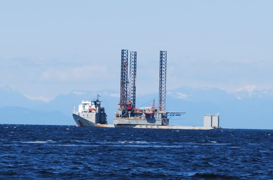
There are a lot of ugly boats on the water, but this vessel takes the prize – not even its designer could love this one. As we passed it at anchor on the SE shoreline of Protection Island outside Nanaimo, we wondered exactly what it could be, concluding that it was most likely a drilling rig of some kind. Shortly after arrival at our moorage in Nanaimo, I downloaded e-mails and there was a cruise log from our friend Linda Lewis on Royal Sounder with the same photo in it. Sure enough, her caption was wondering the same thing, and her husband, Dave Parker thought “it is a Jack-up Oil Drilling Rig. The three similar towers end up being the legs of the platform. The triangular tower is the drilling rig. Why is this here? Dave thinks it is in transit to or from Cook Inlet, Alaska.”
Our usual moorage in Nanaimo has been the Nanaimo Port Authority Marina as it’s near a Thrifty grocery store and a BC Liquor store. In fact we’d made a 2-night reservation to stay there, but after talking to Steve and Shirley in Sidney, we decided to try the guest dock at the Nanaimo Yacht Club – they have a reciprocal with the Seattle Yacht Club, giving us two free moorage nights instead of the $100/night we’d pay at the marina. It’s not quite as close and convenient to city services, but with our provisioning already completed in Sidney, this shouldn’t be a problem. We figured an advantage of early June cruising is the smaller number of boats on the water, and therefore, moorage options are better.
As we cruised into Nanaimo Harbour past the downtown buildings, we could tell with our binoculars that the entire 400’ outer dock that’s reserved for guest moorage was full. When I’d called the night before, a club employee who answered the phone mentioned there was an empty member slip on the inside, and if the guest dock was full when we arrived, to call and remind whoever answered of this. I called the club on my cell phone, and a woman who answered told me we could use slip #18 on D-dock.
The wind was blowing a steady 15 knots, and as we started to round the end of the guest dock to make our way into D-dock, we could see that it was a very tight turn – in fact, we’d have to make three very tight turns to get in, and Kap didn’t feel comfortable at all about doing making those turns with the wind. We opted to bag the yacht club, and I picked up my cell phone and called the Nanaimo Port Authority marina to see if we could still get in there. It was getting late in the day, so this was one of our few remaining options.
A young woman answered the phone and I asked if there was room for us on S-dock – the dock for boats over 50’ that don’t fit in the inner harbor. Sounding very tentative, she asked what our overall length was, and I lied that it was 55’ – after all, we’re a Fleming 55, and 9 out of 10 other Fleming 55 owners save a few bucks by claiming their boat is 55’ – when in fact, it’s just a shade under 62’ when you include the swim step and bowsprit (both take up dock space, so I normally “do the right thing” and say we’re 62” and pay for that amount). She put me on hold for a moment, then came back with a definitive statement that there was no room available on S-dock. Somehow I didn’t believe her, but what could I do?
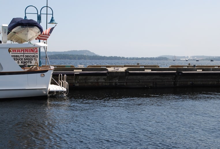
This photo shows where we originally tied up on the “large vessel dock”, normally reserved for boats over 85’ and with a high freeboard. The boat in the photo has a freeboard at the cockpit that’s almost a foot higher than on Flying Colours, and they are OK with the height of the dock.
That left no other options but the “large vessel dock” next to S-dock – and with our low freeboard (the height from the water line to the top of the cap rail), putting out fenders to protect us from the dock would be difficult. I asked about it anyway, and she came back with a query about whether we had at least 4’ of freeboard. Again, I lied and said we did, thinking that we’d figure something out. I’ve seen other Fleming 55’s on that dock during earlier stays, but hadn’t paid attention to what they do. I told her we’d head for the large vessel dock.
When we approached it, the wind was still blowing steady at 15 knots – directly abeam of us and blowing us onto the dock. I was set up for a starboard tie with lines and fenders, but didn’t know how high to raise the fenders until we got closer to the dock. Using the aft helm station, Kap backed us down the fairway, and as soon as our bow cleared the boat in front of us, she started to walk us sideways to the dock. The wind pushed us faster than we expected, and we “kissed” the dock a bit harder than we’d like to, but the rubber rub rail near the top of the dock sufficiently held us off.
Unfortunately, the rub rail also hit right at the height of our hull port windows, and after getting safely tied up we noticed that it had significantly bent the chrome shroud around one port window, breaking the seal around the window. With the seal in that condition, there’s no way we can leave until at least there’s a temporary fix. We immediately got voice mail messages and an e-mail with a photo attachment off to Jeff Sanson at our Fleming warranty yard back in Seattle, as well as to Mike Radding (our technical specialist at Chuck Hovey Yachts in California).
Then we noticed that S-dock directly across from us had two empty sections on it – both with plenty of space for us to get Flying Colours tied up there. I immediately called the Warfinger’s Office (that’s what the Canadians call the Harbormaster) and spoke to a guy on duty there, to ask if we could move over to S-dock. “Sure, if there’s room, go ahead,” he told me. Damn! When I called 15 minutes earlier and talked with the obvious summer trainee college student, she didn’t know what she was talking about – and that cost us some expensive damage to Flying Colours. I felt like having a few choice words with her.
Instead, we waited until the wind died down a bit, then untied Flying Colours and moved her across to S-dock.
Overall, it had been a 7-hour cruise for the day, and we were beat! After taking Gator for a well-deserved walk to water the bushes, we left him on board and headed for Penny’s Palapa – a surprisingly good Mexican place on a floating dock next to the marina office. We really needed a margarita!
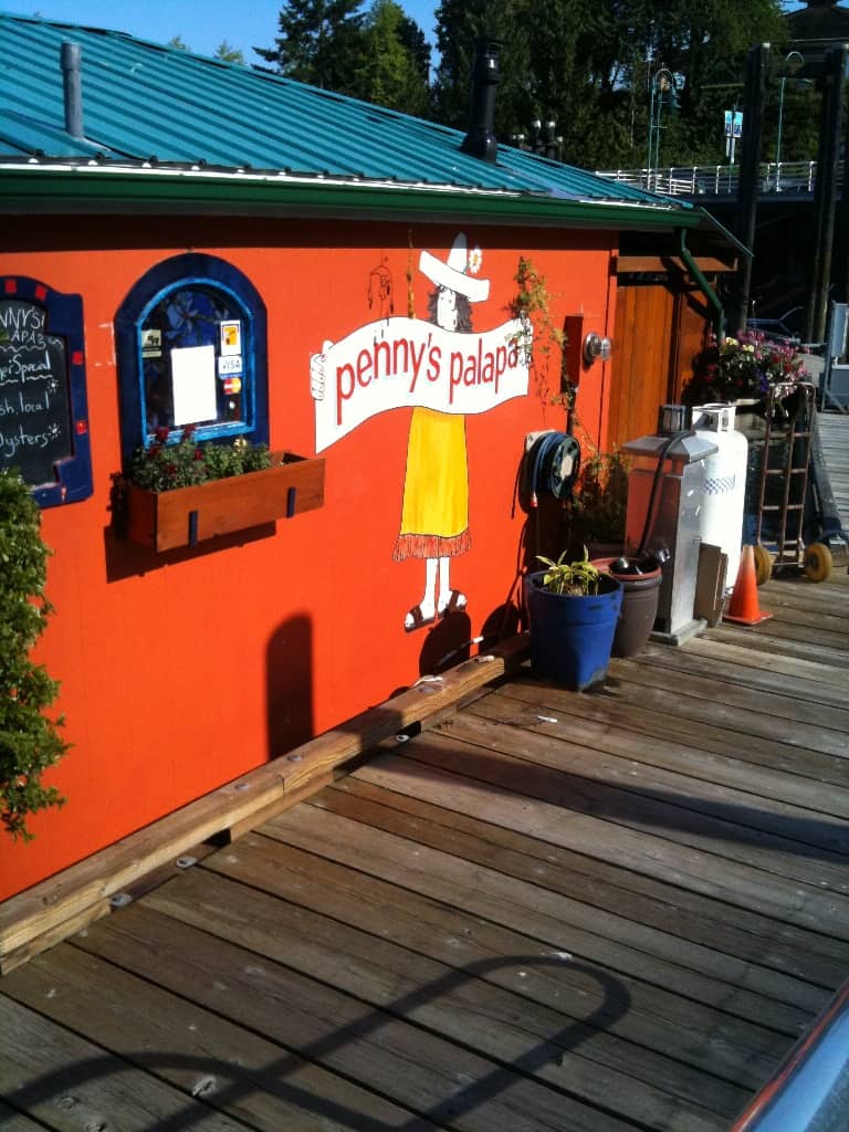
Penny’s Palapa – a floating Mexican cantina tied up to a dock next to the marina office. They serve fresh lime margaritas, and although the menu is small, the food is always pretty good.
Next morning we learned that the fix to the damaged port window frame isn’t all that bad. We’ve now calked the ¼” wide crack to seal it up, and have made plans to return Flying Colours to Sidney for our return home on the 20th and it will be properly repaired at a Fleming warranty yard while we’re gone.